Supposed threats to coastal military installations ignore science
By Bob Endlich
“Data from CO2 measuring stations and from the Sewell’s Point and all other tide gages may clearly refute these assertions, but NPR and its colleagues will not change their minds.”
“The Sewell’s Point tide gage shows that the rate of sea level rise has not changed since the gage was installed in 1927, and is unchanged from our use of fossil fuels. It’s time to base our policies on sound science, instead of manmade global warming fiction and scare stories.”
National Public Radio’s March 31 “Morning Edition” program carried a “news” story claiming that rising seas threaten a number of U.S. coastal military bases. The commentary was so laden with factual errors that listeners might have thought it was an early April fool’s joke. Unfortunately, it was not.
NPR remains so wedded to its belief that humans and carbon dioxide emissions are causing a fossil fuels–driven global warming catastrophe that its reporting has been compromised, and it is unable to think critically or report honestly without resorting to activist claims and fake news events.
Real journalism would have at least included passing references to alternative views and sources. But they were absent in this story, which in truth is a splendid example of ignorance or deception—reader’s choice.
Host David Greene introduced the sea level segment, noting that President Trump is taking steps to reverse Obama-era policies that called [manmade CO2-driven] climate change a national security threat. Reporter Jay Price then expanded on the national security theme, claiming the Sewell’s Point tide gage (or gauge) at the Norfolk, Virginia Naval Station shows that seas are rising there at the highest rates on the East Coast.
His errors began right from the outset. Sea level rise measured at Sewell’s Point is 4.59 millimeters (0.18 inches) per year. That’s less than recorded by neighboring Virginia tide gages: the Chesapeake Bay Bridge Tunnel gage measured an average sea level rise of 5.93 mm annually; up the Delmarva Peninsula, on Virginia’s Eastern Shore, Wachapreague gage records show average seal level rise of 5.37 mm/year.
Tide Gages Only Part of the Story
In principle, a tide gage is like the float in a toilet tank. As water flows in, the gage shows a rise; as water flows out, it records a fall. However, tide gages are unable to determine whether changing water levels over time are due to changing sea levels, or whether the land on which it sits is rising or falling. That needs to be determined by another measure. Using GPS data from many years is a good method to determine the long term vertical motion of the ground near the tide gage.
Tide gage data are readily available at NOAA’s “Tides and Currents” web site. But Dave Burton’s Sea Level Info website has added carbon dioxide concentrations to the tide gage height, correlating the two topics. His site shows clearly and directly that CO2 concentrations have had no effect on rates of sea level rise. The Sewell’s Point sea level and CO2 plot is shown in Figure 1 below.

Figure 1. Sea Level Rise at Sewell’s Point
http://www.sealevel.info/MSL_graph1.php?id=8638610
The rate of sea level has fluctuated several times over multi-decadal periods, but there is no human-caused CO2-fueled global warming signal in the data. Indeed, the rate of rise has not changed since 1927. In other words, there is no acceleration in sea level rise.
However, the Greene and Price’s reporting make it clear that, as they and NPR see it, sea level rise is definitely human-caused, the result of our using fossil fuels. In essence, this has morphed into a looming dual disaster: a national security threat and a dangerous manmade climate change threat. Their viewpoint is clearly political, unsupported by objective scientific data.
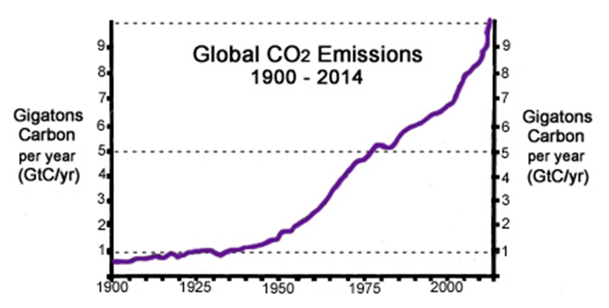
Figure 2 presents the best available estimate of global carbon dioxide emissions from 1900 to 2014. As it demonstrates, when the Sewell’s Point tide gage was installed in 1927, the global rate of CO2 emissions was about 1 GT/year. The most recent available estimate of CO2 emissions (2014) was about 10 GT/year. Comparing this CO2 data with the Sewell’s Point tide gage record in Figure 1 makes it clear that the rate of sea level rise at Sewell’s Point is unchanged over this nine-decade period.

Figure 2. Carbon dioxide emissions over time.
http://notrickszone.com/wp-content/uploads/2016/11/CO2-Emissions-1900-2014-GtC-per-year-ps-.jpg
In summary, there is no human-caused CO2-fueled global warming signature in the tide gage record at Sewell’s Point – or anywhere else in the tide gage records, including the Battery in New York City and in San Francisco, where tide gage records go back to the time of the U.S. Civil War.
NPR’s Unreliable “Experts”
But this does not prevent NPR from quoting Retired Rear Admiral David Titley, then of the climate-obsessed Obama Administration and now of Penn State University, who declared that the sea level rise at Norfolk is definitely a result of human-caused climate change. (As many before me have pointed out, the U.S. military is and has always been under the direction and control of a civilian president.)
Nor do scientific facts prevent NPR from using this recent story from the always alarmist Union of Concerned Scientists and this flawed methodology from another “global warming is manmade” group, claiming that human-caused global warming has raised sea level “about eight inches since 1880, and the rate of rise is accelerating.” Data from CO2 measuring stations and from the Sewell’s Point and all other tide gages may clearly refute these assertions, but NPR and its colleagues will not change their minds.
Sea Level Rise and Land Subsidence
It is easy to see why this report and this reporting are in error. The majority by far of the apparent sea level rise in the Norfolk-Hampton-Newport News area is caused by two important non-climate-related forces: subsidence associated with an ancient subterranean impact crater, and the compaction of former wetlands filled in for development.
The center of the huge Chesapeake Bay Impact Crater is near the southern tip of the Delmarva Peninsula, and its proximity to Sewell’s Point is graphically shown here. The crater’s structure below the Hampton Roads region is causing most of the present-day subsidence of the terrain in this area.
Examining a satellite-based map of the Norfolk area reveals nearly straight shorelines, right angled corners, piers and other indications that show the terrain has been modified by dredging and filling of former wetlands to suit the needs of developers. When marshes are dredged and filled, the once muddy, wet fill continues to compact for decades, resulting in slow terrain subsidence, just as this article from The Economist reports: “In America, groundwater extraction without commensurate recharge [of water in the subsurface formations] is responsible for 80% of subsidence.”
In short, no matter how much NPR’s reporter and sources claim sea level rise is human-caused and CO2-fueled, the tide gage data show no correlation between rates of sea-level rise and human production of carbon dioxide. Clearly, the gradual inundation of these coastal areas and the apparent rise of sea level shown on tide gages at Sewell’s Point, the Chesapeake Bay Bridge Tunnel and Wachapreague are actually due primarily to the effects of the Chesapeake Bay Impact Crater and filled-in wetlands that are still losing water content and compacting.
A secondary cause, as noted by Paul Driessen and Roger Bezdek’s recent article, “Sea Level Rise—or Land Subsidence,” is land subsidence due to the pumping of vast amounts of groundwater for urban and agricultural purposes.
And yet, the 31 March NPR story does not even mention terrain subsidence. To NPR it is all about “climate change” and the notion that – if only human use of fossil fuels could be reduced or ended – the gradual rise of oceans off Hampton Roads could be stopped, and national security interests would be protected. Nothing could be further from the truth.
If WUNC reporter Jay Price or the program editors at NPR were the least bit curious, they would have investigated the sea level tide gages operated by NOAA for the entire country. They are displayed on NOAA’s “Tides and Currents” web page, which also features the map in Figure 3.

Figure 3. Map of United States and Canada showing sea level trends. Arrows represent the direction and magnitude of change.
https://tidesandcurrents.noaa.gov/sltrends/sltrends.html
Up or down arrows on the map shows whether seas are rising or falling in a particular area, with the rate of sea level rise or fall indicated by the color of the arrow. Many areas of temperate and tropical seas feature green “up” arrows, depicting gentle rates of sea level rise. However, in Scandinavia and many areas of Canada and Alaska, the seas are falling. How could that be?
Isostatic rise and continental drift
In first year earth science courses, students learn that during the coldest years of the last ice age – the Wisconsin Ice Age, as it is known in North America, some 23,000 years ago – thick glaciers, up to one or even two miles deep, covered much of North America and Europe. They covered Canada and extended as far south as below the Great Lakes states, Manhattan and Long Island in New York, smothering the lands under incalculable billions of tons of ice that compressed those parts of the continents.
In areas where the glaciers have melted away, “isostatic rebound” continues to take place: with the immense weight of glacial ice from the last ice age removed, the land surface is actually rising, rebounding from the compaction caused by all that ice, as shown in Figure 4.

Figure 4. Image from aircraft: Successive shorelines show isostatic rebound.
In fact, intrepid investigators poking around Alaska on NOAA’s Tides and Currents map might even find that at Skagway, Alaska the Tide Gage shows sea levels falling rapidly (by geologic standards, anyway) at 17.63 mm (0.7 inches) per year!
Returning to the Continental USA map in Figure 3, green and yellow arrows along the East Coast indicate slight and moderate rates of sea level rise, with the Middle Atlantic States having somewhat higher rates of sea level rise. Along the Gulf Coast are red arrows; tide gages three show high rates of “sea level rise” in Louisiana.
But again, is it rising sea levels, or something else? Such as coastal erosion or less silt being deposited in the Mississippi Delta, thanks to soil conservation measures taken in America’s heartland, to prevent soil erosion. More about that in a moment.
Again, returning to our first-year earth science course, we’d learn that over the past 50 years a new specialty has emerged: Plate Tectonics (aka, continental drift). During that time, scientists demolished the previous “consensus view” – that continents were fixed in place on Earth and did not (could not possibly) move. We now know that the continents rest on “plates” that move and collide with other plates and their continents, and that tectonic forces cause regional areas of uplift and subsidence.
Using the tide gage map display as a guide, readers may well discern another possible explanation. There is a good chance that the variable rates of sea level rise and fall might be caused by the nature of the land at the shore itself. The new science of plate tectonics suggests that these variable rates of “sea level rise” – or land subsidence – may be due to different tectonic influences on different shores.
To recap, tide gages tell us the history of water movements recorded by the height of the gage float. However, the gages have no knowledge, and no way of knowing, whether the piers on which they sit are rising, as in the case of Skagway – or falling, as in the case of coastal Louisiana.
Preventing Soil Erosion Has Unexpected Consequences
It is doubtful that the NPR reporters took the time to learn about the December 1897 edition of National Geographic magazine. In it, E.L. Corthell reported that, ever since the Mississippi River was channelized, the yearly flooding of the Mississippi Delta had ceased. Without the fresh annual addition of silt to the surface, the entire delta continued to subside, with the result that Gulf of Mexico waters were encroaching up the delta, and farmers and other homesteaders were abandoning their lands.
And there was this: the subsidence of the entire Mississippi Delta area accounts for the tide gages showing large rates of sea level rise in coastal Louisiana.
One wonders if any reporters have studied Egyptian history – and if any of them learned and remembered the story of the annual Nile flood that once brought fresh nutrients to ancient fields, in the centuries and millennia before the Aswan Dam was built.
Things are never quite as simple or straightforward as they might seem, or we might like.
From Long Island and the Jersey Shore to South Texas, the entire coastal plain of the U.S. East and Gulf Coasts consists of unconsolidated sediments. When municipalities and industrial sites pump ground water for use by citizens, governments, and industry, the water is removed from the interstitial spaces in the sediments. The formations for the most part are not solid rock, but consist of sands, clays, silts, gravels and mixtures of these materials. When groundwater is pumped out, an important part of the soil mass is removed – and the land subsides.
The use of long-term GPS data can discern the difference between land subsidence and sea level rise. We just need to examine all the data, before jumping to conclusions.
The Chesapeake Bay Meteor
Close to Norfolk Navy Station and the Sewell’s Point tide gage, some 35.5 million years ago, a large bolide, or meteor, struck – evaporating sediments in the area and creating a huge crater in the crystalline basement rock below them. It was a cataclysm for plants and wildlife for miles around!
The crater center is close to the present southern extent of the Delmarva Peninsula, Figure 5. This Chesapeake Bay Impact Crater has affected geologic and geographic development of the lower Chesapeake Bay in the millions of years ever since.

Figure 5. Map of Chesapeake Bay Impact Crater, showing rim boundaries of the crater. The Sewell’s Point tide gage is where the outer rim black line crosses from Norfolk into the James River.
https://upload.wikimedia.org/wikipedia/commons/c/ca/Chesapeake_Crater_boundaries_map.png
During that time, sediments once again collected in the Virginia Coastal Plain, where the Potomac, Rappahannock, York, and James Rivers converge into lower Chesapeake Bay. At the end of the Wisconsin Ice Age 20,000 years ago, sea levels were some 400 feet lower than they are today – and the Susquehanna River flowed 80 miles east, to Norfolk Canyon in the continental shelf, as it emptied into the Atlantic.
The Susquehanna and its tributaries became drowned river valleys, and in August 1682 the British established Norfolk as a port town. Today, the Norfolk, Virginia, area is home to perhaps the largest naval facilities in the world. But the Chesapeake Crater continues to induce subsidence of the land, because of the fractured nature of the earth below these towns and cities at Chesapeake Bay’s mouth.
Figure 6 presents a profile view of the crater, along an east west line through Kiptopeke on the Delmarva Peninsula. One can begin to appreciate the extent, immensity and effects of the fracturing that the meteor impact had for tens or hundreds of miles outward from the impact point.

Figure 6. Diagram showing profile view of the complex structure of the Chesapeake Crater. The Sewell’s Point tide gage is some 6 miles south-southeast of NASA-Langley; the crater complex is 50 miles across.
https://upload.wikimedia.org/wikipedia/commons/f/fe/Chesapeake_Crater_profile_view.png
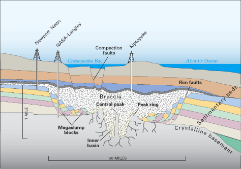
Contrary to the scare stories, including the recent one from NPR, sea levels have been rising at Hampton Roads, Virginia for a long time – certainly since the Wisconsin Ice Age ended, and probably since the Little Ice Age finally thawed out, beginning in the 1800s.
The Sewell’s Point tide gage shows that the rate of sea level rise has not changed since the gage was installed in 1927, and is unchanged from our use of fossil fuels. It’s time to base our policies on sound science, instead of manmade global warming fiction and scare stories.
Robert W. Endlich, resident of Las Cruces, New Mexico, served as a Weather Officer in the U. S. Air Force for 21 Years. From 1984 until 1993 he provided toxic corridor and laser propagation support to the High Energy Laser Systems Test Facility at White Sands Missile Range. He has worked as software instructor and software test engineer at New Mexico State University and published in the technical literature.
He was elected to Chi Epsilon Pi, the national Meteorology Honor Society, while a basic meteorology student at Texas A&M University. He has a bachelor’s degree in geology from Rutgers University and a master’s in meteorology from the Pennsylvania State University.
h/t to Rob Bradley at Master Resource
The title of this article leaves room for one to believe that NPR somehow mistakenly “bungled” the story.
Fat chance.
NPR post-2008 has been unabashedly preaching to the far-left choir of their primary donors. They alternate between Trump-bashing, eco-scare, and emotional “diversity” stories, ad nauseum. It is pure, unadulterated, 200-proof propaganda that makes Drudge and Breitbart look like Walter Cronkite.
I like The Car Guys. Too bad Click and Clack aren’t around anymore. Still, they play re-runs. BTW: Cronkite was a commie. I think you’re gonna have to go further back in time to find a reputable reporter. Murrow perhaps?
Click and Clack were funny when they were fresh, but their shtick wore out long ago. It’s rather morbid that NPR intend, apparently, to replay their shows in perpetuity. All things must pass. Please.
Edward R. Murrow may not have been a Commie, but he most certainly was not a conservative.
Want statistical proof of NPR’s bias? Easy. Look up every US congressman who has been convicted of a crime over the past 10 years or so. Then go through the audio archives of NPR’s hourly news headlines. Most recently: “Former Florida congresswoman Corrine Brown was found guilty today of stealing money from a charity …” No mention of her party affiliation at all in the story.
When it’s a Republican they always say something like “Republican congressman Joe Blow was convicted of bribery today …”. Every time. Believe it.
Green(e) is the name? Probably not a coincidence.
It is what one expects from NPR. It seems very similar to critiques on this blog about the BBC or the Australian ABC. There is something about “public” broadcasting.
“There is something about “public” broadcasting.”
You haven’t noticed a very similar “something” about the corporate mass media, Tom?
Strange . .
NPR and PBS is marginally worse. It is rather like discussing fat or thin sumo wrestlers, though.
The difference is that I get the pleasure of paying for NPR and PBS, whether I watch them or not.
JohnKnight,
It should be expected that anyone who has an axe to grind will try to make their crusade appear in a favorable light. Making money for a corporation and all of its public stockholders is certainly a motivating force to be selective in what is presented. However, that never seems to rise to the level of rationalization exercised by SJW zealots who are convinced that they are answering Gaia’s calling.
That is why scientists should be detached observers and not marching in parades with clowns.
What’s this “corporate mass media” that has you in such tither?
Tom,
“NPR and PBS is marginally worse.”
I’m interested in the “something” . . which appears to me to be organized/orchestrated propaganda. (and I doubt that Russia is behind it ; )
“What’s this “corporate mass media” that has you in such tither?”
G.E., Newscorp, Disney, Viacom, Time Warner, and CBS, for the most part.
Another cringe-worthy example is PBS NewsHour’s 2013 report that 90% of Greenland’s ice mass had thawed in July 2012.
The reason broadcast journalism gets so little respect is that they deserve so little respect. PBS NewsHour is supposed to be America’s leading television news team. But when they needed to hire a “Reporter/Producer on Science and Climate Change,” do you think they looked for a scientist, or maybe a dual-major science & journalism grad?
Of course not. Competence was not one of the job requirements.
Instead, they hired a young, pretty, feminist film criticism major, fresh out of college. Her senior honors thesis at UNL was entitled, “Unzipping Gender.” She’s a perfect conduit for every nonsensical climate scare that comes down the pike.
Her byline is on that story reporting that 90% of Greenland’s ice mass had thawed. But she’s obviously not the only innumerate member of the PBS NewsHour Team. They are all that bad. Nobody there noticed a problem with that story.
No wonder they all believe in CAGW.
Ivy league i’ll bet.
Are we still paying taxes to support those NPR yard birds?
yes
The public broadcaster CBC in Canada has been using the recent spring flooding in Quebec (haven’t seen floods like this since the 1950’s) to beat the CACC drum, “expecting to see more extreme climate events in the future with global warming”. No need to even check with the prognostications of the IPCC which have not linked climate change with bad weather.
All are controlled and driven by far-left ideology. There is simply no assignable evidence to show human activity is responsible for any change in sea level. We cannot separate out natural variation since there is so much we do not know about any changes over long periods of time. Blaming CO2, a trace gas essential to life on the planet, is idiotic. It is a fraud, aimed at global social control by a large group of far-left zealots.
CAGW is a convenient, sciency-sounding (and therefore unassailable), catchall explanation that just happens to be nicely in line with their political and ideological beliefs. What good fortune for the 80% of all “reporters” and “journalists” who just happen to be Progressives! Isn’t that amazing!
If the sea level is rising in the Chesapake, won’t that help the Navy. Their ships floar on water not on land. They may need to raise docks every once in a while. But at less than 6mm (1/4 in.) per year they will get their moneys worth out of docks before they need to be rebuilt.
Good observation. And the rise in relative sea level means that much less dredging. Foregone dredging is a cost that should be included in the benefits column.
A simplistic observation, but not really a very good one. Base operations happen mostly on land. The issue is flooding during storms and high tides. Perhaps Walter had his tongue firmly planted in cheek?
“A good journalist doesn’t find the story. A good journalist makes the story!”
L Lane, 1978
That reminds me of Yellow Journalism which tried to sell more newspapers. One of its characteristics was:
A trumped up story on climate catastrophes will sell more papers than the boring truth.
Yes, climate journalism is a fresh yellowing of reporting, now enhanced with fake news.
https://rclutz.wordpress.com/2017/01/12/yellow-climate-journalism/
It seems to me that many journalists see themselves as architects of ‘change ‘,it gives them a buzz .it doesn’t seem to matter whether the change is for good or ill as long as they can say ‘i was there ,we did it ‘.
What did Superman tell Miss Lane about her making up stories?
Opportunism, not conviction. The almighty dollar wins again.
When hasn’t NPR bungled a story. These days all they are are Democratic Party talking point readers.
Is it bungling, if the story has the impact the handlers want it to have?
Owen: +10 and counting
The “greenhouse” effect of CO2 increase is logarithmic. Therefore correlation between alleged linear tidal gauge and CO2 concentration seems plausible. However, what is the underlying cause for sea level rise. Is it thermal expansion? Then, provide argo data. Is it land ice melting? Then, please, exhibit the data as well!
“Changes in global sea-level are caused by – but not limited to – four main mechanisms:
1. Changes in local and regional air pressure and wind, and tidal changes introduced by the Moon.
2. Changes in ocean basin volume by tectonic (geological) forces.
3. Changes in ocean water density caused by variations in currents, water temperature and salinity.
4. Changes in the volume of water caused by changes in the mass balance of terrestrial glaciers.
Mechanism 3 (temperature-driven expansion) only affects the uppermost part of the oceans on human time scales. Usually, temperature-driven changes in density are more important than salinity-driven changes. Seawater is characterised by a relatively small coefficient of expansion …
… temperature-driven ocean water expansion will therefore not in itself lead to lateral displacement of water, but only lift the ocean surface locally. Near the coast, where people are living, the depth of water approaches zero, so no temperature-driven expansion will take place here (Mörner 2015).
Mechanism 3 [thermal expansion] is for that reason not important for coastal regions” (climate4you).
From climate4you—Oceans:
“Changes in global sea-level are caused by – but not limited to – four main mechanisms:
1. Changes in local and regional air pressure and wind, and tidal changes introduced by the Moon. 2. Changes in ocean basin volume by tectonic (geological) forces. 3. Changes in ocean water density caused by variations in currents, water temperature and salinity. 4. Changes in the volume of water caused by changes in the mass balance of terrestrial glaciers.
Mechanism 3 (temperature-driven expansion) only affects the uppermost part of the oceans on human time scales. Usually, temperature-driven changes in density are more important than salinity-driven changes. Seawater is characterised by a relatively small coefficient of expansion …
… temperature-driven ocean water expansion will therefore not in itself lead to lateral displacement of water, but only lift the ocean surface locally. Near the coast, where people are living, the depth of water approaches zero, so no temperature-driven expansion will take place here (Mörner 2015).
Mechanism 3 [thermal expansion] is for that reason not important for coastal regions”.
“… Is it thermal expansion? …”.
==================================
“… temperature-driven ocean water expansion … [mechanism 3 does] … not in itself lead to lateral displacement of water, but only lift the ocean surface locally. Near the coast, where people are living, the depth of water approaches zero, so no temperature-driven expansion will take place here (Mörner 2015).
Mechanism 3 [thermal expansion] is for that reason not important for coastal regions” (climate4you).
tegirinenashi says: “The “greenhouse” effect of CO2 increase is logarithmic.”
Are you prepared to defend that assertion?
How very odd?
There are a few trollops who plaque here frequently.
A couple of those trollops rarely fail to attack anyone pointing out that CO2 effect on lapse rates is logarithmic.
And they challenge the concept in the very same aggressive belligerent manner you have chosen.
Homer, trollop.
Just how many ID’s, does a trollop need to visit and legitimately comment on science websites?
Apparently, none of the IDs they already have and abuse.
ATheoK – “How very odd? … And they challenge the concept in the very same aggressive belligerent manner you have chosen.”
Excuse me, aggressive and belligerent? To ask someone to defend their assertion? And I’m not sure what your blather about many ID’s is in reference to.
May I ask what the range of CO2 concentrations does this logarithmic lapse rate pertain to? Is that question allowable to someone who makes a blanket assertion that is easily shown to mean that a single molecule of CO2 traps as much global heat as any other doubling? That seems absurd to me, and yet you are questioning my questioning.
Thomas Homer: the reference to multiple IDs is projection. You will increasing see the Trolls accuse posters of using the tactics that they thrmselves have been guilty of for many, many years, now that their activities are becoming more transparent.
“who plaque here frequently”
A good toothbrush will take care of that.
In all my years of reading and studying atmospheric science and climate change, I don’t think I have ever seen someone argue that the impact of increasing CO2 on atmospheric temperature does not decrease logarithmically. It has nothing to do with CO2 molecules, but with the absorption bands of CO2 molecules. When those bands become saturated with absorbers, adding more absorbers has no impact.
As science goes, the logarithmic decrease of the impact of increasing CO2 on temperature is pretty settled. The quantity of that impact is where the disagreement has always been, and remains to this day.
I have seen some argue that the affect isn’t logarithmic, but it is close to it.
It’s a good enough approximation for most calculations.
jclarke341 – May 12, 2017 at 12:37 pm
“I don’t think I have ever seen someone argue that the impact of increasing CO2 on atmospheric temperature does not decrease logarithmically”
What is the starting concentration of CO2 from which it decreases? Decreasing logarithmically means that it starts with its highest value. If we consider the Earth’s atmosphere the same as it is now, but with no CO2 and then add in the first molecule, ‘decreasing logarithmically’ means that the second molecule represents a doubling and the greatest impact per molecule. That’s absurd right? Drawing this forward, Earth has roughly 2^47 square meters of surface area. If we continue adding molecules of CO2 until there is one per square meter then we’ve now doubled CO2 47 times. How much heat can one molecule per square meter ‘trap”? Using the 1.6 degrees per doubling figure means that one CO2 molecule per square meter would ‘trap’ over 75 degrees of heat. That’s absurd, right?
So what starting concentration of CO2 are you using for this logarithmic decrease, and how did you derive it?
Bob Endlich:
thank you for this excellent analysis. Have you tried corresponding with the writer of the NPR story?
Yes!
John S.
The short answer is no.
The longer answer is that I have tried emailing some of the NPR folks and interviewees, as well as with local folks of the Alarmist Persuasion. Usually I start off with, “if you look at the data. . . ,” where the ellipsis has a link to a specific data set, such as you see in this post. Usually there is no reply, but if there is, it’s emotional, ending with, “think of the children and grandchildren.”
First, great to see the author reply. Second, sadly, he is correct that contacting NPR (or local newspaper) is futile (if local paper is, like this locale, run by progressives). For about 50 yrs, people going into “journalism” dreamed of exposing the next Watergate scandal, yet they uniformly manage to turn a blind eye to any scandal in a prog cause. The open hypocrisy of CAGW “scientist” advocates burning fossil fuel on utterly unnecessary travel is one example. Another fine example is the open corruption of Hillary, Bill, and the Clinton Foundation, which has never been touched by NPR. The entire “Russia meddling” story, which NPR covers every day, is a deflection cooked up in the Clinton camp. The content of the Podesta and DNC emails hacked (ok, let’s say by russian intel) are solid proof that Hillary used State Dep’t to shill for donations to CF, help the donors by telling foreign govt’s of the donor’s “needs” (recent story in Brietbart re: former PM of India describing this) and get Bill speaking fees. Clinton camp attacks the messenger (russian hackers) to avoid the message, and ever since the election, NPR and progressive press follow this Clinton evasion. Open corruption that could take down the rich and powerful, it’s made to order for an ambitious young NPR reporter, but none of them-NONE- show any interest. Sad indeed.
I believe Trump is in the process of de-funding or at least seriously reducing NPR funding. It may have survived the last temporary ‘appeasement budget’ but it has been stated it is one of the government programs that is in the cross hairs. Like the Universities it is mired in the swamp.
Trump cannot fund, nor can he de-fund anything. All money is appropriated by Congress.
Correct…..but he can control the budget through the approval process. Same difference.
Different sameness…..it’s an “all or nothing” thing, because he has no line-item veto. Once he signs the appropriation bill, he can’t defund, nor can he spend un-appropriated monies.
So it doesn’t make it on the budget. The President controls line items by having them removed from the budget or he vetoes. During the last budget go around NPR at one point was specifically removed. Don’t know if it stayed that way but it was definitely served notice.
Darby the useless!
Of course Trump does not fund.
Technically, the House writes the funding bills.
Now darby doo, tell us how eager all of those Congressional Republican representative are and how supportive of NPR and PBS, they are?
NPR and PBS will be lucky to still have their names after the next few budget sessions. There are quite a few republican representatives who believe the word “public” in NPR and PBS constitutes fraud and abuse.
ATheoK, I mean Griff, I’m glad to see that you are no more capable of producing an intelligent post than you were in the past. I’m old and cranky, and I like consistency, even in my Trolls!
Even if NPR loses its federal govt funding, I will hazard a guess and say that George Soros and/or the Rockefeller Foundation will step in to make up the funding loss–especially if Soros and the Rockefellers already view NPR as leftist in its political orientation. Might even drive NPR further to the left.
Agree, but at least we won’t be subsidizing the propaganda and it would be appropriately flagged as political (and I doubt it could continue to be called National Public Radio, which I doubt). Face it, the MSM and university systems are propaganda arms of the swamp. AGW hysteria would not exist without them.
Gee I’m sure these boys dropped a huge load on the Clinton loss, both in declared and undeclared support, plus loaded up on green stocks after NYT 95% sure thing on the election. Steyer, who tried to buy the election swore that next time he would be controlling the Democrat org after blowing millions on a weak candidate. I hope they keep losing. Soros doesn’t look strong enough to make it if Trump gets reelected.
http://www.bing.com/images/search?view=detailV2&ccid=8zvGnphU&id=D1F88C713D415A854B1F577B06753EBACE71B1D0&thid=OIP.8zvGnphU4XP7krmLtF36rAEsCm&q=george+soros&simid=608014637245796136&selectedIndex=0&PC=SMSM&ajaxhist=0
CD in Wisconsin
Possible. However if didn’t turn out so well with “Air America”.
NPR does do a lot of reports that don’t make any sense about global warming, pushing the pro-alarmist agenda. They did a story a few years ago about roads buckling because of global warming. They talk as if we have no common sense. The sun isn’t getting any hotter, and they expect us to believe that these roads would not have failed if it hadn’t been for a 2 degree rise in average air temperature? Any poor design or poor construction that fails can now be blamed on a 2 degree temperature rise. “Well our design would have worked if it wasn’t for that 2 degree rise in temperature over the last 100 years!”. NPR asks for donations, I’d like to know where to donate to get them off the air.
Bob, a great analysis of the Norfolk area geology. I have always admired how your mind works! I’m afraid that Adm Titley has fallen off the deep end of climate catastrophes.
Paul,
Nice to hear from you again. Thank you for the kind words.
Almost fifty years ago the Air Force sent me to Penn State for graduate Meteorology, and the late Hans A. (Hap) Panofsky, knowing that I had a bachelors in Geology, had me present a lecture on what we knew at that time about past climates from the geologic record. What we know now! It would be interesting to have a debate with RADM Titley today.
Readers, Paul Demmert and I were Advanced Weather Officers at the same time many years ago, and worked on similar projects after I retired and was working as a GS employee for the Army.
The taxpayer-wind-solar-electric car- SC@M-funders aren’t buying the “save the planet” garbage (see all the polls). So, gotta tell SCARIER stories.

LAUGH — OUT — LOUD.
Ooo, yeah. Sea level rise threatens national security.
U.S. Armed Forces (2014 inventory)
(youtube — mute the “music”)
NPR: Excuse me, Mister General. Mister General?
General, U. S. Army (off duty): WHAT!
NPR: Sea level rise is threatening national security.
General:
Janice you have it all wrong, that’s why they mark ships hulls, to records sea level rise so the ship will not get swamped. /sarc
http://www.boatnerd.com/news/newsthumbsb/images-12-3/7-Baie-St-Paul-12-26-12-db.jpg
PS – I liked the music, especially near the end, would loose all the impact otherwise.
Duncan — lol. 🙂 (glad you liked the “music”)
+1: Plimsoll is turning over in his grave! LOL
That opening photo of a B-52 preparing to land on the USS Nimitz is just tremendous. The advent of the Supercarrier made it possible to operate long range strike bombers at sea for the first time. What were once land based only bombers such as the iconic B-52 and the B-1 Lancer can now effectively operate from carriers. This has vastly increased the scope and capability of naval aviation.
It could also be noted here that due to their high operating altitudes, these bombers will probably not be threatened by sea level rise in the near future.
“That opening photo of a B-52 preparing to land on the USS Nimitz is just tremendous” And impossible.
TonyL merely transposed his numbers — happens to the best of us. So. He trusted the sneaky fake photo creator re: the opening photo. But, TonyL was RIGHT (as to B-25’s).
The Doolittle Tokyo Raiders was a group eighty men from all walks of life who flew into history on April 18, 1942. They were all volunteers and this was a very dangerous mission. Sixteen B-25 bombers took off from the deck of the USS Hornet, ….
(Source: http://www.doolittleraider.com/ )
Note: markl, this was not to inform you, but merely to clarify and amplify re: TonyL’s typo.
“…But, TonyL was RIGHT (as to B-25’s)….” In the Doolittle raid the B-25’s were never intended to return to the carrier. Only take off. They landed/ditched in China. I’m nit picking….it doesn’t take away from the success of the mission. There wasn’t enough runway length or strong enough arresting gear for landing such large aircraft or room for them to land on the carrier as they consumed most of the deck since they didn’t fit below deck and their fuel loading wouldn’t permit the return anyway. I’m no expert on the subject and welcome correction.
Enthusiastic? Certainly. But let us [make] clear that USAF B-52 operations DO irregularly schedule at-sea interceptions with USNavy air fleets, and DO irregularly meet at sea to work against USNavy assets in training operations against enemy fllets and enemy single ships.
The largest plane to take off and land from a US fleet carrier was a C130 propjet. Worked adequately, but required the deck to be cleared of too many other aircraft to be convenient for regular operations. Here, the photo shows the low level flight cooperation between the two forces. B-52’s do cross the ocean, do intercept ships, and do practice mine-laying and anti-ship rocket (missile) exercises.
B-25’s DID take off from WWII fleet carriers to attack Tokyo, and in that action, WERE successful in forcing the Japanese to change plans in their offense and attacks that allowed the Midway and Coral Seas battles to be successful.
Okay, markl, good point, however…. TonyL did use the phrase “operate from,” not take off from… .
I’m no expert either — I have no idea whether B-25’s can land, but, if a C-130 can, my guess is a B-25 can.
Doin’ the can can. (Ha! 🙂 )
However, Janice, YOU MADE A MISTAKE — markl was talking about not LANDING ON (not taking off from). Oops! *blush* Anyway. 🙂
While I know of no B-52 that has landed on the flight deck of an aircraft carrier, they do occasionally fly below them (the flight decks, that is):
http://tailhookdaily.typepad.com/tailhook_daily_briefing/2008/06/b-52-pilots-and.html
Good images of a BUFF flying past the USS Ranger. Can be found on StrategyPage, too.
Tonyl
What?
Janice
Did he also transpose B1?
Though landing a B-52 on a carrier is impossible as you state many here may not know that they have landed a C-130 Hurc on an aircraft carrier multiple times and gotten it back off again.
BTW the B-52 and C-130 are from the same era. Both came into service in the mid 1950s and both will be in service for at least another 20 years.
But their longevity in service doesn’t come close the granddaddy of major military weapons/equipment that is still in service. The Browning .50 caliber machine gun holds that record. A couple years ago the military decided to modify all the M2 .50 caliber machine guns in service and in the inventory to eliminate the need to manually set headspace and timing. To do the modification all the receivers (the main body of the machine gun) had to sent in to a central modification facility. They were shocked when they received several receivers dating from 1933 when the weapon first went into production. Despite repeated attempts to find a more modern replacement for M2 the beloved weapon remains in service with all the services and the bark of that machine gun will most likely still be heard long after every poster here is pushing up daisies.
There is one other firearm in the US military that has remained in service longer but since 1986 has not been general issue like the M2 still is. That is the M1911A1. In service since 1911 with the current form coming into service in 1924. When, in their ultimate wisdom, the US Army decided to make the POS 9mm Berretta M9 the standard issue side arm, we in SF told them we would keep the M1911. Though it is a more difficult firearm to learn to shoot accurately, that .45 round has a lot more stopping power than the 9mm and the M1911A1 is very reliable in almost every condition. To this day it remains in service and for the last few years, with real combat experience behind them with that Italian POS 9mm, the Army has rethinking it’s terrible decision to adopt it.
Sea-based B-52s are nothing compared to space shuttle landings on carriers. /s
Landing the C-130 on an aircraft carrier is possible because of the ability to land at a slow speed, good anit-skid braking, and reverse thrust. In fact, practice landings are normally not touch and go’s, as are the practice for most aircraft, but stop and go’s, where the 130 comes to a complete stop, and takes off in the remaining runway.
The Doolittle raid was never intended to be a true military success or even accomplish much damage.
The Doolittle raid sent several very loud and clear messages to Japan.
A) We, can attack japan anytime and anyplace.
B) We are fully willing to sacrifice men and equipment during attacks on Japan.
C) From that point in the war on, do not expect America to retreat one step.
Admiral Yamamoto’s personal worry that Japan was going to rouse a “sleeping giant” was shared with few peers; but that worry resonated louder through the following years.
Admiral Yamamoto also knew that weaknesses many Japanese attributed to Americans were false and mostly based on cultural differences.
Several of these ‘cowardice and moral weakness beliefs’ were directly addressed by Doolittle’s raid.
While America “knew” very little about Japanese capability, resources, manpower and Japanes ability to keep stretching their supply lines; much information was derived from Japanese equipment, supplies and training programs.
a) Japanese equipment was essentially stripped of non-essentials, especially personal comfort or personal safety.
b) The first Japanese soldiers, airmen and naval forces were very well trained and frequent training drills kept their skills high.
c) After a much too rapid geographical expansion, Japan’s new recruits received less and less training. With supplies limited, all Japanese forces scaled back training drills.
• – 1) Extreme examples were seen towards the end of the war where Kamikaze pilots were only trained for take off, not landing; though one pilot did manage to return safely.
d) When America chose Guadalcanal as a stop point; the earlier American-Japanese naval night battles were disastrous to American ships as American Naval Forces did not focus on night training. While Japanese forces actively practiced night maneuvers.
• – 1) As the battles around Guadalcanal progressed, skilled night fighting Japanese naval forces became fewer, while America’s very slow radar learning path increased many times. (Early night battles had radar ships being assigned to rear column positions because of Naval commander did not trust radar and because some of the less bright officers believed they were supposed to “protect” the specially equipped radar ships.
There are many more similar examples on all WWII fronts between Allies and Axis. These comments are just a few centered around the Doolittle raid.
Just as critical as some of the larger efforts, smaller extensive and very desperate events helped our successes and the overall war effort.
e.g. Chinese villages/villagers were “punished” when Japanese officers learned that the Chinese had aided the American fliers.
Actions the Chinese took, because they saw how important it was to the Japanese that American fliers be captured and punished.
Initially, to deny Japanese soldiers minor successes than to save Americans, the efforts grew to great importance as all of China became involved in helping American fliers to escape while stopping Imperialist Japanese.
Cheers!
Now some of the other commenters, who know far more history than I, can fill in details. 🙂
If we made one of the the iceberg carriers proposed during WWII, we could land a b-52!
Two other factors in the drop in the quality of Japanese pilots as the war progressed.
The first to you already alluded to, that Japanese equipment lacked in personal protection.
American planes were built heavy with plenty of armor, for pilot as well as engine. Japanese planes were built light with next to no armor. This meant that the Japanese planes were much more maneuverable than their American counterparts. No single American plane could go toe to toe with a Zero and survive. So the American pilots developed the wingman system that made up for this lack of maneuverability.
Back to my original point. The heavier American planes could take a beating and still get their pilots back to base safely. The Japanese planes tended to disintegrate the first time they were hit. Also American planes had bladders in their fuel tanks that prevented fuel leaks. The bladders also prevented fires in the gas tanks.
Beyond that, the Americans used their submarines to rescue many pilots that had been shot down.
Because of this the life expectancy for an American pilot was much greater than for a Japanese pilot.
A second factor was America’s greater population and industrial capacity. Because of this the Americans could afford to spend a longer time training new pilots, and new pilots could be assigned veteran handlers until they had a chance to learn the ropes of actual combat.
A B52 landing on a carrier deck? That would be one big-as carrier.
With a drag chute a B52 would need over 4,000′ of ground to land.
It needs about 8,000 ft of ground to take off.
I don’t know that there have been that many 8,000′ ships built.
RAH
I own a 1911 and an M9. I concur with your assessment.
Would love to own a Ma Deuce just for fun but I guess the government would take exception.
Folks,
Since we are on the sidebar of aircraft from the 1950s, I have some direct experience with them. More than 50 years ago I was a B-52 forecaster for the 91st Bombardment Wing (Heavy) SAC, at Glasgow AFB, Montana. We were tasked for operation CHROME DOME, an airborne alert mission where two of our B-52Ds, fully prepared for war, took off and flew a route from Northeast Montana, to Illinois, to near Cleveland, Ohio, off the coast of New Jersey, thence northward, refueling the first time off the Canadian Maritimes. The route was to the North Pole, where they turned left, refueled over central Alaska, and then out on the northern rim of the Aleutian Chain to almost to Russia, and a U-turn, returning off the southern rim of the Aleutian Chain, the Gulf of Alaska to south of Seattle, and then a left turn to return to Montana. When they returned, the next two took off. We did this for six weeks straight, for each tasking.
The aircraft gross weight was close to the maximum for the D model, 450,000 pounds, and so the takeoff performance was closely watched. The temperature and pressure altitude determine the density of the air entering the aircraft engines, and that density is critical to the thrust the engines can develop at full throttle. This is where I came in, for the temperature and pressure altitude forecast for takeoff. We had a “centralized” or “consensus,” forecast aid for the temperatures, which I soon learned to distrust and then ignore. I later learned that the consensus guys deliberately ignored a rapid rise in temperatures, over 15F in an hour, as spurious. In fact, when skies were clear, with light winds, that happened every day.
The takeoff distance was about 12,800 ft on our 13,500 ft runway, so my temperature forecast became a critical element for successful takeoff under the demanding conditions of maximum aircraft gross weight.
Later, I deployed with the wing to Guam, where we participated in operation ARC LIGHT, where our B-52s were used to bomb targets in Vietnam, Cambodia, and Laos. Each of our B-52Ds could 108 500# bombs.
So, as a young Lieutenant forecaster I became very wary of this notion of centralized forecasts and the “consensus” of others, after all, I was responsible for the forecast, not they. Now over fifty years later, with operational forecasting experience on three continents, I still regard the opinion of others regarding the future state of the atmosphere as something to be approached with abundant skepticism.
Later, I flew as a crewmember on C-130A and WC-130A aircraft, but that is another story.
Robert W. Endlich
The fake science news is directed at NPR listeners, not fact checkers that might look at tide gauge data.
Daily opiate dose for the addicts. Sad.
I’ve got my addictions, mac and cheese can’t be called an addiction can it ?
I didn’t think so 🙂
Are you eating it alone often?
Do you hide boxes of macaroni and cheese in plastic bags in the toilet tank?
Does eating mac and cheese cause you to miss work? Family gatherings?
Are you unable to pay your bills due to your mac and cheese expenses?
lolololol
🙂
Guilty on all counts.
Just a seeming legitimate investigation (2011) with no acceleration.

Church, J.A. & White, N.J. Surv
https://link.springer.com/article/10.1007%2Fs10712-011-9119-1
It is a pity that in such an AGW sceptical country as the US that you have a lot of vertical land movement that make it hard to nail true sea level behaviour. Locally, on the east coast of Australia there has not been any SLR in my lifetime and I challenge anyone to show me their own observations of specific benchmarks to the contrary. If anything, it is lower than it was 70 years ago.
I’ve seen alarmist news and headlines that used New Orleans as the one example given for sea level rise in the U.S. Anyone with half an ounce of physical geology science class expose should immediately be angered by that tactic of distortion. There is no lack of bias in the media sources planting fraudulent ideas and half truth, regardless of the large unorganized numbers of AGW skeptics. This is called the (mostly) silent majority and they only get a word in edgewise every few years while the advocacy agents are firing all day long every day.
The Audubon Society is very busy in San Diego using this same scare tactic, “ReWild Mission Bay”. Because of projected sea level rise and a return lease of bay front land they have decided to claim 240 acers and return it to swamp land. Total cost is estimated for this project to be 100 million! When asked where the money is coming from the answer was we will find it. They all contribute to PBS don’t you know.
Richard Kiser,
Thank you for mentioning the Audubon Society.
A little over a year ago Rob Bradley was kind enough to post my article, Audubon Goes Over the Edge, https://www.masterresource.org/debate-issues/audubon-goes-over-the-edge/ which takes Audubon to task for its climate alarmism and disregard for our feathered friends.
That article was also picked up in Canada and the UK.
Robert W. Endlich
Lost all respect for the Audubon Society back in the ’80s when I discovered just how cheaply they could be bought. While I have no personal, first-hand knowledge of how similar organizations of their size behave (WWF, SC, H$U$, PETA….) I have little doubt they are any different. While most of them might have started out honestly wanting to do good, they have all failed miserably in my opinion.
PMK
When large sections of continental shoreline rebound upwards, on a long delay from the loss of glaciers in the last ice age, wouldn’t that rebound effect itself cause some sea level rise at other coastal regions that are not rebounding? If ground surface transitions from being underwater to being above water, there has to be a displacement of water outwards into the ocean. That displacement has to manifest itself as a rise in sea level, does it not?
I was wondering about this, too. Looking at the map in the article, you can see quite some area in the north is rebounding. Surely this also happens in other places than Canada/Alaska. And surely it’s not just the land rising (pushing the shorelines farther out, which IMO probably has limited effect on global sea level) but I guess the sea floor must also be rising in that area.
Considering the article mentions at Skagway the land rises >17mm per year, the sea floor in the area must also be rising around this level. Which is apparently 3-4 times the rate of global avg SLR. All this water is displaced and moves somewhere else. In other words, an area where seabed rises at this rate, causes enough water to move away which could increase an area 3-4 times that size at the global avg rate.
There’s lots of water around Alaska and Canada (many islands) and surely also around other areas in the world where there is rebound. Of course at the same time I guess there are plenty of areas where sea floor sinks. What could be the net effect of this and would it have any significance?
PS: forgot to mention, half an hour of googling did not answer this question, anything I found discusses only the local effect of the shore rising, not the displacement.
Remmit, there are three separate vertical land motion processes to consider. 1. Isostatic rebound is where land rises once the weight of the ice sheet is removed. Portland Maine is an example used in essay Pseudoprecision in ebook Blowing Smoke. Thanks to crustal plasticity, that same rebound can cause sinking along more southerly adjacent coastlines. 2. Subsidence, as the post discusses for Norfolk Va. 3. Plate tectonics. In any subduction zone, the subducting plate pushes the overlying plate up. That is the case along most of Alaska’s coastline where the Pacific plate is subducting. The essay used Juneau. The post used Skagway. Same tectonics.
Thank you Rud.
Not quite, Kurt, et al: The massive weight that pressed the Ice Age covered land down (One ton per cubic meter of ice, 2,240 lbs. per cubic meter of water), now having been melted, deepens the ocean basins and actually makes room for more water volume then was contained in the original ice.
About 5 years ago, Coral Davenport, then of the “National Journal” did a long form alarmist piece about sea level rise at Newport News and Norfolk that was all about climate change as the cause and that left out, just as NPR did, any mention of the asteroid crater subsidence or subsidence due to landfills and water extraction. She parlayed her alarmist work into a job as a featured climate science writer for the “New York Times.” She’s done very well as a science writer for someone that graduated with a degree in literature from Smith. No doubt her familiarity with fiction has served well as a siren of catastrophe.
Virtually all the writers and advocates of AGW like Bill McKibben are English, History, Poli Sci, and Journalism majors. No science background to speak of.
and white, guilt ridden for the color of their skin, middle upper class brats.
What in the world makes you think it’s real, Gary?
(I don’t think Western civilization will last much longer, in part because the “smart” folks (who aren’t in on the take-down) seem incredibly easy to con . . )
Nice article, well written article.
FWIW, for the author, I must add this. . . . 1) General Fred Lewis was a childhood friend of mine. . .and yes, he was a weather nerd back then too. Fred and I used to enter science fairs together — he entered his weather station, and I entered my radio station. Fred went to college and majored in physics and meteorology, and I majored in electrical engineering. He stayed true to his childhood passion, and I. . . .wandered off into medicine, and wound up a surgeon.
2) I earned my BS in Electrical Engineering at NMSU and did my first programing there. I still am very involved in programming. . . .although I no longer use Fortran to analyze power lines. I’ve progressed to C# and SQL, and write programs to help in the management of addiction.
Once again. . .thanks for the interesting article!
Ben W.
Yes, I first met Fred when he was a PhD Captain in the Air Force at the old Air Force Global Weather Central in the early 1980s. We were assigned to the same division.
Years later he was a Brigadier General and head of Air Force Weather when I was working technical transition of the Army’s Integrated Meteorological System, IMETS, which provided digital weather and weather effects as overlays into the Army Battle Command System, the ABCS.
General Lewis came to Ft Hood, Texas, home of the Army’s first Digital Brigade, Division and Corps a number of times to see how his Air Force Weather troops were able to integrate Army and Air Force Weather products into the ABCS.
Good Times.
“Ft Hood, Texas, home of the Army’s first Digital Brigade, Division and Corps”
Interesting stories about military weather. Thanks.
What exactly does a “Digital Brigade do?
“What exactly does a “Digital Brigade do?” Please don’t say anything about it referring to a medical exam.
Sea level rise is one of the things that the news really needs to get right. I get in discussions all the time with people clearly driven by nothing but faith (in experts/media). As noted here, all the data is easy to see. And if sea level rise were actually accelerating one would expect that SOME gages would show it…or how about a couple.
There is simply nothing to see here in the data. We’re given excuses “Oh, its things like re-channeled rivers and erosion” yet island based tide gages that don’t have enough land or rivers large enough to cause the earth’s crust to rebound faster/slower don’t show anything either. None do.
Any claims of a “recent acceleration” in sea level rise are almost certainly premature. Those who prepare tide tables are quite aware of several cyclical astronomical influences besides the monthly and 20-year lunar cycles. These cycles may interact constructively or destructively, causing the apparent sea level to increase or decrease for decades. Therefore, before making any claims about recent changes, one should consider just what these astronomical influences are doing (with respect to their phases) and add or subtract them from the measurements to see what the long-term changes actually are. Once again, those who are making claims to support the alarmist position haven’t done their homework. The science can’t be settled because all the science hasn’t been examined. Tide gauge measurements and even subsidence/rebound aren’t enough to see the whole picture.
Great article! Love the combined plate tectonics, meteor impact crater, and post glacial isostatic rebound analyses!
Even in the 1990s NPR was called “National Peoples Republic Radio”.
It only got worse in the Obama Regime that elevated NPR to the Official Government Propaganda Organ.
Now, NPR is a “Ship without a State” and no dock.
NPR will keep on publishing fabricated data, analysis and interpretations to satisfy NPR and nothing else.
We are fated to suffer NPR for many years to come.
The path to eliminating National Propaganda (by) Regressives:
1) Eliminate all Federal funding.
2) Eliminate the “set aside” frequencies – open those up to normal license bidding.
3) Oh, and eliminate their free licenses.
Now, they will still survive – but only in the totalitarian Regressive “blue” States. At least the rest of us won’t be funding them – or listening to the ideological descendants of Goebbels that broadcast over them.
Good Read, excellent graphics -Thanks; Hans
Very sad now how most MSM now all sing from the same hymn sheet regarding CAGW/climate change. You hear it everywhere in most references to any news and weather related calamity. What is really sad is that the writers of these news items know the general population has no clue about science details behind these items so they just write it up real simple.
Sea Level Rise is probably the easiest wool to pull over everybody’s eyes. Joe the plumber is going to have no idea what they are are talking about when someone starts talking about glacial rebound, or delta subsidence and how that affects local sea level. Most people think the ocean is just a big bathtub and sea level is the same everywhere on the planet. Nothing could be farther from the truth.
When Huricane Katrina hit, much was said about the damage being caused by rising SLR. Of course, we know it was an engineering failure. Same for Huricane Sandy, but then they leave out that it hit at a King Tide, making the storm surge several feet higher than if it had hit a week earlier. And then it isn’t even news when no substantial hurricane has made landfall since then while tellin tall tales how these hurricanes are going to be bigger and badder than evah before. No wonder so many people just know all this is a dirty rotten lie. They maybe don’t know all the science behind it, but they can smell a rat behind all this.
I think “Joe the plumber” would have a very good understanding of water level and displacement. Let’s not sell him short. Most people skilled in the trades are well-grounded in practical reality.
SJW’s, on the other hand…
Excellent post.
But You can add this graph: https://tidesandcurrents.noaa.gov/sltrends/50yr.htm;jsessionid=9F29E24AC159FE8819891DFCBFF57094?stnid=8638610
It follows a trend with 60 years swing along the coast.
There is, indeed, evidence of an approximately sixty year cycle in some sea-level records, perhaps related to the AMO.
In most places the effect is slight. An apparent exception is Murmansk:
http://sealevel.info/AMO_vs_murmansk_6.png
http://www.sealevel.info/MSL_graph.php?id=Murmansk
Thanks for the AMO graph.
You can find it at many station if You use NOAAs site.
At the Battery the 50 year trend is 2,4 during the 1920s and 1970s and 3,8 during the 1950s. Nice fit!
https://tidesandcurrents.noaa.gov/sltrends/50yr.htm?stnid=8518750
When using Dave Burton’s excellent website’s Tide Gauge charts, the following should be selected:
Show calculated linear trend (linear regression)
Show linear trend 95% prediction intervals†
The 95% prediction intervals clearly bounds the linear direction of the underlying data, upper and lower. Thick line selection and CO2 overlay should seal the ability to clarify whats actually going on with Sea-Level, and more important, pull the rug out from under the Church & White claim of “recent acceleration” as they desperately try to concatenate poorly resolved satellite altimeter data with (still linear) Tide Gauges!
Yeah, somehow humans can manage to build infrastructure that allows them to work around a daily sea-level rise and fall of over 12 feet in busy ports like Seattle, but that estimated rise of 1 foot per century is gonna really have us baffled? What’s the difference between “advocacy journalism” and propaganda? It’s the noble cause corruption that allows the journalists doing it to wear a halo, while actually doing damage to society through the misdirection of resources. If the “facts” counter the noble narrative, then the facts lose. Doesn’t matter what the issue is.
The example I reference is the Bay of Fundy where sea level changes over 50 feet twice a day, and people fish in those waters. But hoards of ‘climate refugees’ will be ‘baffled’ as you say and not be able to get out of the way of an 1/8th inch annual rise?
Where Ivanka gets her information.
What an excellent posting! The illustrations of the receding shoreline through isostatic readjustment and of the varying rise and fall around North America’s coastline are going straight off to my geography teaching colleagues. Meanwhile, you can only despair at the reason for the posting being necessary in the first place…
http://www.sealevel.info/MSL_mitrovica23_trendtable.html
A good resource, 23 tidal gauges with minimal changes in land levels. Covering Europe, Australasia & the Americas.
Average 1.6mm/year sea level rise.
You don’t graph CO2 overlaid on sea level to prove or disprove a correlation. You graph CO2 in the x-axis and sea level in the y-axis and generate a least square correlation line and look at its correlation coefficient.
If that’s what you do, Donald Kasper, you can find strong spurious correlations between any two things with monotonically increasing trends, as Willis memorably pointed out, a few years ago.
(OTOH, you could plot rate of sea-level rise vs. CO2, and you’d get a roughly horizontal line.)
What is it with all these guys who cut and paste figures from other papers. Don’t these guys ever go get original source data?
Cut and paste blog science. Too funny.
Irony is lost on trolls.
Wow, Steve, that’s a really insightful criticism of the material presented. Devastating, even. /sarc
I have previously posted images of cliff undercuts around the Mediterranian, that appear to demonstrate that there has been no sea-level rise. But here is a similar undercut in the Phillipines.
How old is such a large undercut – 500 years, perhaps? The supposed 5mm/yr sea-level rise over the last 60 years would make sea levels 30 cm higher by now. Does this look like a 30 cm sea-level rise, into that undercut? (The sea here is in a protected bay inside the Phillipine archipelago, so there are no large rollers hitting the cliff.)
It is hardly credible that land rise is exactly the same as sea-level rise, in so many locations, as the sea level rise theory would suggest.
Ralph
These are the similar cliff undercuts in the Mediterranean (where tides are minimal). Notice any sudden sea level rises here? Or are they again proposing that the land has again risen in step with the proposed sea level rises?
Ralf, there is a geologic explanation for these undercuts and why the rock below/above the undercut is not weathered away when sea levels were lower. Personally I do not dispute sea levels are slowly rising, just not with the alarmist spin around it.
https://geographyas.info/coasts/features-of-erosion/
>>there is a geologic explanation
I think you mis-read that explanation. There is no softer layer at that point in these cliffs. And there is no erosion shelf, to reduce the power of the wave. (the Philippines undercut was not simply on the beach, but all around the cliffs)
Had there been lower sea levels a century ago, the notches you can see here would now be partly submerged – even at low tide. But they are not. The low tide is perfectly leveled with the undercut. (Both these pics were taken at low tide, not that Mediterranean tides are worth noting).
R
It needs reiterating that measuring sea level is not a simple matter, because the seas puddle in areas of higher gravity. The sea is up to 150 m higher in some places – see this informative little video:

This is what the Earth and its sea levels actually looks like (below), gravitationally. So the sea around Britain is 150m (490 ft) higher than the sea around the Gulf of Mexico (and no, you cannot surf ‘downhill’ from Britain to Mexico). So measuring a single sea level for the world (and its assumed rise in millimeters per year) is not exactly a straightforward matter.
Ralph
Presumably these gravitational anomalies don’t change much from one century to the next.
>>Presumably these gravitational anomalies don’t change
No. They are dictated by the continents and the thickness/density of the lithosphere, and so they are permanent features on the scale of tens of millions of years.
R
So called “climate change” is a social mania that is thriving on post normal science, post honesty journalism and an increasingly post rational society. NP R has thrived in this environment and is a leader in post honest journalism.
hunter,
I suspect that “post honest journalism” is a non sequitur. It assumes that journalism was at one time actually honest. The function of newspapers has always been to sell newspapers, not to report factual news.
The difference is that 100 and 200 years ago, papers were open about their partisan affiliations.
It’s only been in the last 100 years that reporters and newspapers started to pretend to be nonpartisan.
That makes the reporters of the past, more honest than modern ones.
I read one paper that said Hampton Roads is sinking – that something like 2/3s(?) of the rise is attributable to sinking. I have to get going here, but will try to get back with the link.
Ooops – more than half – apologies for overstating –
Major Conclusions
Land subsidence and global sea-level rise combine to cause relative sea-level rise in the
southern Chesapeake Bay region.
Land subsidence causes more than half of the observed relative sea-level rise.
Aquifer-system compaction causes more than half of the land subsidence.
https://pubs.usgs.gov/circ/1392/pdf/circ1392.pdf
It is a liberal belief considering their constituency, has a core of truth, that people are stupid and need to be lied to for they will do the “right” thing. The Left feels no guilt making stuff up because of this basic premise. Most things liberals say are constructed for the effect they desire rather than any underlying truth.
In other words, they believe that the ends justify the means.
It is a strange, and disturbing, world indeed when the well informed comments above and the author of the detailed ,critical blog himself are berated by an American Professor as mere “dismissives” , whilst the presenters of a report flawed so clearly by the scientific evidence and even by simple common sense, not to mention poor journalistic practice, would instead be applauded by the same Professor for their “scientific” report.
http://i.imgur.com/syALgGu.png
AMOC slowdown effect:
http://i.imgur.com/KY5iaep.png
Thirty yeas just isn’t long enough, JCH. In fact,
“…an interval of just 30 years is the worst that can be chosen because it is half 60-year cycle…” [Nicola Scafetta, 2012]
As the ocean “sloshes” up and down you get significant variations over periods of a few decades or less, but, overall, the trend is very linear.
At first glance, sea-level rise along the southeastern U.S. Atlantic coast, from Virginia to Florida, seems to show a slight acceleration recently. But when the ocean is “sloshing up” in one place, it is “sloshing down” somewhere else.
Remember Sallenger 2012, about a “hot spot” of accelerated sea-level rise along the northeastern U.S. coast? Sallenger compared sea-level trends thirty years apart, and used data through 2009, with emphasis on the trend at New York City. His paper got massive press coverage, and hundreds of citations. But can you guess what sea-level has done there, since then?
http://www.sealevel.info/MSL_graph.php?id=battery&boxcar=1&boxwidth=3&co2=0&g_date=1890/1-2019/12&c_date=2009/12-2016/12&s_date=1890/1-2019/12&thick
http://www.sealevel.info/8518750_The_Battery_1890_to_2017-01_trend_since_2009_no_CO2.png
Of course, that “slosh down” is just as temporary as Sallenger’s “hot spot” was. As surely as night follows day, every “slosh down” will be followed by a “slosh up,” and vice versa.
Sorry I botched that first link.
“The use of long-term GPS data can discern the difference between land subsidence and sea level rise.”
It depends on how the GPS data is benchmarked. If it is benchmarked to land, the same problem exists.
Sorry, I think ‘calibrated’ would be a better term.
GPS can be used to determine if the land is rising or falling, and this value can be added to or subtracted from the value obtained from the tidal gauges to get a better measure of actual SLR.
First, it is differential GPS that is used to sort tide gauges; diff also uses a second land based signal (hence differential). GPS works off the timing differences (at speed of light) from atomic clocks. So there is no calibration to land. There are about 200 PSMSL tide gauges within 10 km of a diff GPS land correction, but only about 70″of those have reasonably long records, and only about 40 that go back 100 years or more.
A GPS receiver can derive its position relative to the satellite constellation, but orbits decay and errors creep in, so there has to be a calibration at some point. Just as augmentation systems like LBAS or WAAS provide correction signals for ionospheric conditions, there must be an overall system calibration. I just don’t know how it is done. I understand how relative position is derived but I am not clear on how it defines an absolute position.
My understanding is that GRASP and/or eGRASP ever fly they are supposed to help address this problem. I don’t know the details, though.
Except that actual statistical analysis has shown accelerating sea-level rise; except that subsidence is hardly news to anybody, least of all those seriously studying the topic; and except that dismissing CO2′ s effect on sea level because one can’t eyeball a correlation on a graph is pretty silly given the noise level of the SLR signal and the understanding we have of the physical processes involved; except for those gaffes, good article!
Doc Snow, the “accelerating sea-level rise” ceased when CO2 rose above 310 ppmv. There’s been no significant, sustained sea-level rise acceleration since the 1920s.
Ref: https://link.springer.com/article/10.1007%2Fs11069-012-0159-8
The SLR is real, although the causes are numerous and difficult to disentangle. This acceleration you are talking about, however, is not global and not statistically significant.
Care to provide a link to this paper that proves accelerating SLR?
Just commenting on the NPR bias. The truth is simple, when you are selling a product, in this case a reason to undercut civilization and reverse it, along with depopulation, which would be the natural result of enacting measures on climate change, you have to “stick to the script,” no matter what comes up or how often it is disproved. To do less will not sell the product, and that is your reason for being – sell the product. Since the media, both public run and main stream, are committed to selling the product, they have no choice but to continue the propaganda. Their very life blood depends on it. Scientific argument is meaningless to them because they can’t change course without literally dying, since doing so would make them obsolete. Actually, breaking step might well save them, or at least return some credibility and utility, but that would be in the long run, not the short run.
That reminds me of the hour-long interview I heard on NPR a few years ago that gave an open mic to a senior marijuana advocacy lobbyist. He listed all the health cures and benefits of marijuana and research studies in rapid fire mode just like the snake oil salesmen of 1800s.
Meanwhile….
https://www.sciencedaily.com/releases/2016/10/161005160733.htm
https://www.sciencedaily.com/releases/2014/11/141110161123.htm
https://www.sciencedaily.com/releases/2016/02/160210135334.htm
https://www.sciencedaily.com/releases/2013/12/131216080454.htm
https://www.sciencedaily.com/releases/2014/04/140415203807.htm
https://www.sciencedaily.com/releases/2016/03/160316105703.htm
https://www.sciencedaily.com/releases/2017/02/170210131220.htm
I never understand why these posts about sea level never even include the word “eustasy”.
Robert Endlich ==> The nearest Continuously Operating Reference Station (CORS) monitoring land movement is LOYZ (LOYOLA Z, Suffolk, VA). The current vertical movement is shown in the graph here. In the Norfolk, Va area, the land is moving towards the center of the Earth at about 1.5-2.0 mm per year. This is typical for northern Virginia.
Areas nearby, like Portsmouth, VA (built mostly on fill) are subsiding at greater rates.
Thank you, Kip, for that CORS link. However, I don’t think that’s a trustworthy subsidence estimate for Sewell’s Point.
In the first place, the CORS data for Suffolk looks awfully rough, to me. This is their graph (cropped):
http://sealevel.info/Suffolk_VA_CORS.png
In the second place, Suffolk is probably experiencing less subsidence than Sewell’s Point, perhaps a lot less. Suffolk is only about 15 miles from the NC border. and I know that here In eastern NC, and so I presume also in southern Virginia, the local geological structure causes subsidence to decrease as you move either west/inland or south, and to increase as you move either east/seaward or north. Suffolk is 20-25 miles southwest of Sewell’s Point, and nearly twice as far as Sewell’s Point from the center of the bolide impact crater, so it’s a safe bet that Suffolk is experiencing less subsidence than Sewell’s Point. (Sorry, I don’t know how much less.)
daveburton ==> Suffolk is the nearest operating COS station, and gives a good idea of the land mass movement. Sewell Point, which I sailed past just last week (7.5 kts SOG in 30 kt winds) ids built on fill, like Portsmouth’s Hospital Point. One can be assured that the land there is subsiding more rapidly than the solid land mass. As one sees in the Google sat image, Sewell Point is built out into the river mouth, where several large rivers feed into the tidal Chesapeake Bay.
For Sewell, the problem is the land is sinking a lot, while the sea rises a little.
In the end, it makes no difference for the need to raise the base land level. One just can’t blame global sea level rise for the problems there.
Wow, sounds like a wild ride! I rode by there in an old sailboat a few years ago, but the mast had failed earlier in the trip, so we putt-putted through there on diesel.
http://sealevel.info/IMG_20130914_131812.jpg
Um, there’s one huge flaw with your analysis. Look up how much water is in the oceans, now look up the how much water comes from all the events you’re listing. Your saying a 1/100th of a drop of water is responsible for an extra inch in the rise of water in a bathtub.
If you want to actually calculate it, you can find simple conversion factors here.
“If you can’t quantify it, you don’t understand it.” -Peter Drucker
The mass of average dumb s___ and the low brow sources feeding them depict sea level as flat line …. UNTIL …. ayyyyyyy geeeeeeee doublllllllle yuuuuuuuuu! The actual reality, the long rise from the Great Melt onward, with something superimposed, is never mentioned nor discussed. The only real point of discussion is what the the superposed term and how long will it be superposed? In the grand scheme, the rise will end when the interglacial ends. Done. Full stop.
Roflol. Thats a big seal. “average seal level rise of 5.37 mm/year.”. (Sic)
Please correct ‘seal’ to ‘sea’ and delete this reply when. Done.
Must be true, the galciers are melting because of CAGW: Sciencemag says: http://science.sciencemag.org/content/356/6338/580.full
No commets for 2 days and I know for sure, that they have received at least one eLetter.
Pls, correct “glaciers”.
“At the end of the Wisconsin Ice Age 20,000 years ago, sea levels were some 400 feet lower than they are today.” Let’s do some math: 400 feet divided by 20,000 years is 0.02 feet (6.1 mm) per year, or 2 feet (24 inches, about 61 mm) per century. It seems the current rate of sea level rise (aside from local geological effects) is about the same or less than it has been for 20,000 years.
Oops! Make that 610 mm per century.
Excellent post, very informative, showing great understanding of how things work. I will be sending this link on to others. Thank you!
PMK
At noon on Friday, May 12, I emailed reporter Jay Price, and directed his attention to this article & discussion. If he’d wanted to address the concerns raised here, he has certainly had every opportunity to do so. But he has not responded.