Guest Post by Bob Tisdale
In this post we can learn from someone’s mistakes. The author of the post at Slate clearly misunderstands many aspects of El Niño and their relationship with the Pacific Decadal Oscillation…so many that I’ve had to focus on just a few. To confuse matters more, mixed in with those misunderstandings are realities and quotes from ENSO researchers. But first…
ENTHUSIASM ABOUT GLOBAL WARMING
I first ran across the term “global warming enthusiast” in a June 2012 article in The Sunday Times written by the always-entertaining Jeremy Clarkson, who is best known for his antics in the BBC’s Top Gear. The article by Clarkson was Kaboom! It’s my turn to play fantasy climate change. (Paywalled.) Also see the ClimateRealists webpage here. There Jeremy Clarkson wrote:
Science fiction is thriving; only today it’s all being written by global warming enthusiasts.
I’ve used the phrase “global warming enthusiast” in numerous blog posts and in many more comments around the blogosphere since I found that Clarkson article. Occasionally, someone will respond to it with something to the effect of No one is enthusiastic about anthropogenic global warming. Bad things will happen because of it. That always sounded like more science fiction to me.
Well, a recent article indicates there are people enthusiastic about the return of global warming: See An El Niño Double-Dip? at the Slate.com. (A double-dip El Niño? That’s a very odd term. I’ll explain in a moment.) The article begins:
Global warming is about to get a boost.
As this year’s El Niño sets in, early signs are pointing toward the possibility of a rare occurrence: back-to-back El Niño years. If it happens, it would virtually guarantee a new global heat record in 2015 and could help usher in a decade or more of accelerated warming.
The author sounds awfully enthusiastic about the thought of “a decade or more of accelerated warming.” The only thing missing is an exclamation like Yippee!
But the author’s enthusiasm is overshadowed by his misunderstandings, conjectures and blatant errors. But good things can come from them. People who want to learn can learn, and those who don’t won’t.
ENSO DISCUSSION
The title of the article is very strange: “An El Niño Double-Dip?” Sorry. The phrase double-dip was applied to the La Niña events of 2007/08 and 2008/09 and the La Niña events of 2010/11 and 2011/12 because there were back-to-back dips (cooling) in the sea surface temperatures of the eastern equatorial Pacific, separated by off-season ENSO-neutral conditions. See Figure 1.
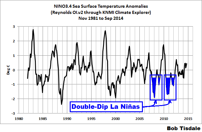
Figure 1
Or if you’d prefer data presented in tables, see the annotated screen cap of the NOAA Oceanic NINO Index (ONI) in Figure 2.
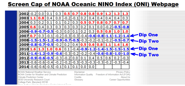
Figure 2
Double-dip would not apply to back-to-back El Niños separated by ENSO-neutral conditions, because those would be rises in the sea surface temperatures of the equatorial Pacific. If someone’s looking for alliteration, they could try repeated-rise El Niños, not double-dip.
I’m not being pedantic about the difference between multiyear and back-to-back El Niño events. El Niño events are tied to the seasonal cycle, also known as phase locking, and as a result they normally peak in boreal winter and decay into boreal spring. See the post Why Do El Niño and La Niña Events Peak in Boreal Winter? An El Niño that does not decay in boreal spring, but lasts through to a second season, defies the seasonality of El Niños.
To further compound the oddness of the headline, the author uses as a reference the NOAA CFSv2 modeled sea surface temperature anomaly forecasts for the NINO3.4 region of the equatorial Pacific, dated October 14, 2014. See Figure 3. The mean of the forecast (dashed black curve) remains elevated, above the El Niño threshold of 0.5 deg C, through May-June-July, which is the ENSO off-season. What’s missing? The return to ENSO neutral conditions in the off-season. It’s absence would suggest a multiyear El Niño, not a back-to-back one.

Figure 3
Also, the author must not be familiar with the “spring predictability barrier” for ENSO forecasts. See of Torrence and Webster (1997) The annual cycle of persistence in the El Niño/Southern Oscillation. The first two paragraphs of it read:
A spring ‘predictability barrier’ exists in both data and models of the El Niño/Southern Oscillation (ENSO) phenomenon. In statistical analyses this barrier manifests itself as a drop-off in monthly persistence (lagged correlation) while in coupled ocean-atmosphere models it appears as a decrease in forecast skill.
The ‘persistence barrier’ for ENSO indices is investigated using historical sea surface temperature and sea level pressure data. Simple statistical models are used to show that the persistence barrier occurs because the boreal spring is the transition time from one climate state to another, when the ‘signal-to-noise’ of the system is lowest and the system is most susceptible to perturbations. The strength of the persistence barrier is shown to depend on the degree of phase locking of the ENSO to the annual cycle.
References to the “spring predictability barrier” can be found in papers from the early 1990s, and the barrier still exists for forecasters.
Bottom line: ENSO forecasts are notoriously unreliable through boreal springtime.
Q: Are back-to-back El Niño events possible, with ENSO-neutral conditions separating them?
A: Yes, according to NOAA Oceanic NINO Index (ONI), a pair occurred in 1957/58 and 1958/59 and another pair happened in 1976/77 and 1977/78.
Q: Are multiyear El Niño events possible, without a return to ENSO-neutral conditions during what would normally be considered the ENSO off-season?
A: Yup, the 1986/87/88 and 1969/70/71 El Niño events are examples.
Q: Has the NOAA CFSv2 model shown any skill at predicting back-to-back or multiyear El Niños?
Nope, sadly it’s too new to have a track record. The NCEP Climate Forecast System Version 2 (CFSv2), according to the linked webpage, “became operational at NCEP in March 2011.” And according to the NOAA Oceanic NINO Index (ONI), there have been no El Niño events, of any kind, since the CFSv2 became operational.
I don’t recall. Was the CFSv2 one of the models that forecast an El Niño for the 2012/13 season? If that’s the case, it highlights one of the problems with ENSO forecasting. The events can be far and few between, so if you miss one, it’s not good for your batting average. Hmm. I wonder what Bob Eucker would say about stats like that. (Sorry, Uke.)
THE PACIFIC DECADAL OSCILLATION
On the Pacific Decadal Oscillation, the author of the Slate post writes (my boldface):
Even if there’s not a second El Niño, a longer-term climate signal is beginning to point in the direction of more frequent bursts of warming over the next several years. Over the next few years, a natural climate oscillation known as the Pacific Decadal Oscillation (PDO) is poised to kick into gear. Historical data has linked the “warm” phase of the PDO with a 15- to 30-year temporary surge in global temperatures. A new paper even shows this sort of natural variability could trump long-term human-caused climate warming in localized areas like the Pacific Northwest.
The PDO can be thought of as the atmospheric manifestation of a stretch of frequent El Niño events. If El Niño is the spark that ignites a months-long transfer of heat between the ocean and the atmosphere, the PDO is an indicator of how much fuel is in the gas tank.
The author of the Slate post clearly has no idea what the PDO is all about.
We recently discussed the Pacific Decadal Oscillation in minute detail in the post The 2014/15 El Niño – Part 5 – The Relationship Between the PDO and ENSO. The PDO Index is a numerical representation of the spatial pattern in the sea surface temperature anomalies of the extratropical North Pacific (northward of 20N), where a positive PDO spatial pattern has warmer sea surface temperature anomalies in the eastern extratropical North Pacific (along the coast of North America) than in the central and western North Pacific (the Kuroshio-Oyashio Extension). That spatial pattern is typically created by strong El Niño events. A positive PDO index value basically represents how closely the spatial pattern of the sea surface temperature anomalies of the extratropical North Pacific matches those created by strong El Niños. The higher the number, the closer the match. Conversely, a negative PDO Index value relates to the pattern created by La Niñas. The PDO Index values have different variations in time than those of an ENSO index (like NINO3.4 sea surface temperature anomalies) because the spatial patterns in the surface temperatures of the North Pacific are also impacted by the sea level pressures (and related wind patterns) there.
Contrary to the mistaken beliefs of the author of the Slate post, the PDO cannot “be thought of as the atmospheric manifestation of a stretch of frequent El Niño events”. The PDO index is derived from sea surface temperatures.
And the PDO is definitely not “an indicator of how much fuel is in the gas tank…” for El Niños. For that one must refer to the ocean heat content data for the tropical Pacific. See Figure 4, which is from the post The 2014/15 El Niño – Part 2 – The Alarmist Misinformation (BS) Begins.
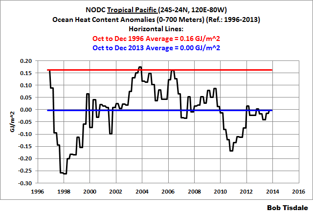
Figure 4
Sorry to disappoint the author of the Slate post, but the warm water available for El Niños has dropped in recent years.
And the author of the Slate post gets something kind-of right, but obviously has no grasp of reality (my boldface).
Even if there’s not a second El Niño, a longer-term climate signal is beginning to point in the direction of more frequent bursts of warming over the next several years. Over the next few years, a natural climate oscillation known as the Pacific Decadal Oscillation (PDO) is poised to kick into gear. Historical data has linked the “warm” phase of the PDO with a 15- to 30-year temporary surge in global temperatures.
It’s very odd that a global warming enthusiast would parrot something that skeptics pointed out about a decade and a half ago. Unfortunately, there is no mechanism through which the PDO (as represented by the JISAO definition of the PDO) can cause global surface temperatures to warm. The PDO index is actually inversely related to the sea surface temperatures of the region from which it’s derived.
The processes that cause the PDO are the same processes that cause natural (sunlight-fueled) global warming or suppress it, and those processes are the ones associated with El Niño and La Niña events.
In the past I’ve written: The strength of ENSO phases, along with how often they happen and how long they persist, determine how much heat is released by the tropical Pacific into the atmosphere and how much warm water is transported by ocean currents from the tropics toward the poles. During a multidecadal period when El Niño events dominate (a period when El Niño events are stronger, when they occur more often and when they last longer than La Niña events), more heat than normal is released from the tropical Pacific to the atmosphere and more warm water than normal is transported by ocean currents into adjacent ocean basins and toward the poles—with that warm water releasing heat to the atmosphere along the way. As a result, global sea surface and land surface air temperatures warm during multidecadal periods when El Niño events dominate. They have to. There’s no way they cannot warm.
Maybe it’s easier to think of the long-term impact of ENSO another way. During multidecadal periods when El Niño events dominate, atmospheric and ocean circulation become hyperactive, leading to a long-term, naturally caused, sunlight-fueled global warming.
Also, during multidecadal periods when La Niña and El Niño events are more evenly matched, as they have been for the past decade, atmospheric and ocean circulation become more balanced, leading to the cessation of the long-term, naturally caused, sunlight-fueled global warming.
CLOSING NOTE
Focusing on the mean again, the most recent forecast for NINO3.4 sea surface temperature anomalies from the NCEP CFSv2 model, Figure 5, shows a decline in the temperatures there over the next few months, meaning no El Niño this season, which would mean no back-to-back El Niños and no multiyear El Niño. See the NOAA Weekly ENSO Update (page 26).

Figure 5
Excellent.
Sorry if this is a little off topic however:
Some commenters, no doubt, will describe Clarkson in very poor terms. However he is a very good paper journalist. His Arctic convoy documentary is quite excellent, and there are others. As regards the convoy documentary, no doubt it is available on YouTube. Everyone should watch it.
Clarkson is onto something here, bouncing Greenland is a minor problem, according to USGS there is a micro-continent rising in the Arctic
http://minerals.usgs.gov/alaska/arcticak/index.html
Now micro-, next milli-, soon kilo- and in no time a mega-continent; the Earth is mega-doomed !
and all because of your patio heater, now you know.
(/sarc)
Jeremy Clarkson punched Piers Morgan.
So Jeremy Clarkson must be a good guy.
PM got off easy. If he stays in the US (on the lam from the UK) much longer, he’s liable to get shot.
The enemy of my enemy, what? 🙂
I think he’s a pretty good guy anyway (albeit a bit of a prat from time to time) but that one act elevated him to superstardom.
Sorry, Andrew, I found his Arctic convoy film poorly researched, as did a friend of mine who served in those waters at that time.
Clarkson concentrated mostly on RN people.
Hi Andrew. So far, there haven’t been any objections to Mr. Clarkson’s name appearing in my post or to my quoting him.
I’ll agree that Clarkson is an excellent journalist. I may not always agree with his conclusions, but I always enjoy how he reaches them.
Cheers.
Why would anyone read Slate for information on science?? Then again, why would anyone read Slate…
Now just stop right there. “Dear Prudence” is an immensely guilty pleasure.
Does Prudence talk about climate change? 😉
Prudie deals with climate issues routinely, like here:
And here:
Frank – dunno but she might come out to play. After all, the sun is up, the sky is blue …
The author of the Slate article is Eric Holthaus, who bills himself as a meteorologist. I can’t find his education or credentials anywhere, but at any rate, there are plenty of meteorologists who have consumed the watermelon Red kool-aid, and are faithful Climate Change believers, regardless of the data and the falsification of the GCMs, regardless of the Pause. For Guys like Eric, they have faith in Climate Science that can’t be shaken by real-world data that Climate Change due to man-made CO2 is not happening.
At any rate, if he is a real meteorologist, then as Bob shows, Eric’s understandings of the various cycles in the Pacific Ocean are deficient.
In one of his other more recent posts at Slate, Eric “The Red” Holthaus actually calls for no more IPCC reports, since his Faith in CAGW leads him to believe that the science is settled, and it is time to act. Yawn.
I know many here at WUWT wholeheartedly agree that there should be no more IPCC ARs, but for the opposite reason. The IPCC’s use of science and climate models are fatally flawed by self-serving political motivations.
There is NOTHING worthy of ANY study whatsoever of Slate !
If you look at SWARM detected by changes in the Earth’s magnetic field, can be seen to be associated with anomalies of weather in the winter. Very cold in North America and a warm in Europe and northeastern Asia.
http://www.esa.int/var/esa/storage/images/esa_multimedia/images/2014/06/magnetic_field_changes/14582173-1-eng-GB/Magnetic_field_changes_node_full_image_2.jpg
@ren; please elaborate on what SWARM is, this is very intriguing!
“ESA’s Swarm mission will unravel one of the most mysterious aspects of our planet: the magnetic field.”
http://www.esa.int/Our_Activities/Observing_the_Earth/The_Living_Planet_Programme/Earth_Explorers/Swarm/ESA_s_magnetic_field_mission_Swarm
http://www.esa.int/Our_Activities/Observing_the_Earth/Swarm/Swarm_reveals_Earth_s_changing_magnetism
http://vortex.accuweather.com/adc2004/pub/includes/columns/newsstory/2014/650x366_11071715_hd22.jpg
http://www.accuweather.com/en/weather-news/polar-vortex-to-vist-central-u/36890008
http://www.cpc.ncep.noaa.gov/products/stratosphere/strat_a_f/gif_files/gfs_t05_nh_f00.gif
You have to realize this was a sermon to try and pump up the flock. Being factually correct is not important.
Here is the Clarkson article: http://climaterealists.com/index.php?id=9775&utm_source=feedburner&utm_medium=feed&utm_campaign=Feed%3A+ClimaterealistsNewsBlog+%28ClimateRealists+News+Blog%29&utm_content=Google+Reader
A repeat El Nino could be called Boobs – n_n. Slate writers are also often called boobs.
Wouldn’t it be more fitting if a double dip La Nina was associated with boobs?
Depends on the age of Nina…
So it’s La Nada after all?
Kaboom! It’s my turn to play fantasy climate change. (Paywalled.)
Try here.
http://climaterealists.com/index.php?id=9775&utm_source=feedburner&utm_medium=feed&utm_campaign=Feed%3A+ClimaterealistsNewsBlog+%28ClimateRealists+News+Blog%29&utm_content=Google+Reader
Ah, perhaps I should read the rest of the comments before posting.
The ting about warmists is that they double count El-Ninos for their purposes. When there isn’t one they say (rightly) that the ocean is accumulating heat. But when there is one they cry “Alarm” the world is melting when in fact what the world is doing is cooling down by releasing the heat from the oceans into the atmosphere and then into space.
El_ninos??? bring ’em on. The more the merrier.
And I’m not Irish, I forgot the h in ting.
Wondered about that, boyo. 😉
Apparently I’m confused. I thought we were in a cool PDO phase, with more la nina’s, not a warm PDO.
Clearly the Slate writer is a climate boob. Yes, we are in the cool phase of the PDO, so it’s absurdly ignorant for a CACA enthusiast to welcome what’s “about to kick in” in the North Pacific.
As I write, a warm front is energetically pushing through my native PNW, an early harbinger of the Pineapple Express & Chinooks we can expect this winter, no matter how cold.
http://www.woodfortrees.org/plot/jisao-pdo/from:2000
The PDO short term is positive. I am hoping it heads negative soon. We might say this cool phase seems a bit unstable
I love reading posts from Bob, he has clearly has tons of knowledge on climate science. But some tough love, he could improve on getting on his messages across more clearly and concisely. To criticize using the term double dipping when it would be more appropriate to say back to back rise is a nit pick, and distracts from the discussion of the real errors. Many people use the term double dip for for items that aren’t increases, douple dip inflation etc., its not appropriate but I would like Bob to try and focus on starting his messages with the biggest, most important points he has, in this case the biggest error he found. I myself read that he had a list of misunderstandings of what PDO is, read that he was criticizing the use of the term double dip, and found myself thinking “this is a nit pick list, there isn’t going to be any substantial criticism of the science”, but you have to read more to see that is not true. Don’t assume all readers will read all of your posts, you need to grab them with a whopper first to keep them interested, if they see a minor issue noted they will likely assume the rest are even less substantial.
How about Twin Peaks?
Alternatively, in market chart reading, it would be called the Witch’s Tits formation.
Bob needs to at least dot point his conclusions. I have said it many times. I’m sure a lot of people including me don’t have the time to extract the nuggets from his usually long articles and seemingly endless graphs in other posts.
” according to NOAA Oceanic NINO Index (ONI), a pair occurred in 1957/58 and 1958/59 and another pair happened in 1976/77 and 1977/78.”
Hmmm, and in 1997/98 we had the big one. Could the back to back pair release as much energy as the one big one? I know the data set is limited and just my SWAG that there appears to be a 20 year period for large heat exchange events. Maybe it only happens in the positive phase of the PDO?
I could be hallucinating the whole thing as well 🙂
Those double El Nino in the 1950s took place on the rise from the solar minimum between cycle 18/19. There was a big flood event in the PNW in 1955/56 during the low of that minimum.Then cycle 19 became the highest solar peak on the chart in the 3 years following that minimum.
The winter of 1955/56 in the PNW was quite cold and snowy. Our family snow skied many times at elevations between 3,000 and 4,000 feet that winter in southeastern Washington State.
That winter was also saw a major flood event on the coast of the PNW. Washington St may not have got hit as hard as Oregon and California did during that flood event. The storm track might have been centered on southern Oregon.
Thanks, Bob.
Today the NOAA-NWS Climate Prediction Center – CPC, ENSO Diagnostic Discussion – 6 November 2014 says:
“There is a 58% chance of El Niño during the Northern Hemisphere winter, which is favored to last into the Northern Hemisphere spring 2015.”
“During October 2014, above-average sea surface temperatures (SST) increased slightly across the eastern half of the equatorial Pacific (Fig. 1). The weekly Niño indices were between +0.6°C (Niño-3.4 and Niño-1+2) and +0.9°C (Niño-3) at the end of the month (Fig. 2).”
See ENSO Diagnostic Discussion – 6 November 2014, at http://www.cpc.ncep.noaa.gov/products/analysis_monitoring/enso_disc_nov2014/ensodisc.html
But, the ESRL-PSD: Multivariate ENSO Index (November 5 ’14, Klaus Wolter, NOAA) shows:
http://www.oarval.org/MEI_1950-2014-Nov5-ts-Opt.png
This is a very mild and declining El Niño event.
See http://www.esrl.noaa.gov/psd/enso/mei/
Another good chart showing the rise & fall of the oceanic current driven warming of 1977-98, preceded & followed by intervals in which the blue area below the neutral line equals or exceeds that of the red above it.
Says Mr. Natural.
And Mother Nature. Please see Paul Vaughn’s chart from the recent ocean circulation post:
http://wattsupwiththat.com/2013/12/17/solar-amo-pdo-cycles-combined-reproduce-the-global-climate-of-the-past/
Paul Vaughan
December 17, 2013 at 3:43 am
Which shows climate swings are driven primarily IMO by the sun & the ocean it warms or cools & covers or uncovers with clouds, as per Bob’s comment above about the sun shining on the equatorial west Pac.
Many other excellent charts & graphs in that blog post by H. Luedecke and C.O.Weiss, too.
Bob: Are there any good studies of the rate of movement of warm and cold water around the No. Pacific. It seems to me that the relative warmth of the California current now must be water that went north in the Kuroshio at some point in time (I realize that upwelling/downwelling also may be involved). Surely we have means of tracking these things with markers of some sort? If the rate of flow varies significantly over time, the timing of subsequent changes could speed-up/lag and affect other changes.
R2Dtoo, I don’t recall having any in my library.
For the last year or so, I’ve been looking for a study about circulation patterns in the Pacific, one that I had read abut 5 years ago. Nice, simple diagrams, current volumes, etc. For the life of me, I can’t find it. I’m sure there a plenty of other studies, though.
The Kuroshio averages about three mph. The Gulf Stream flows at around three or four knots:
http://www.onr.navy.mil/focus/ocean/motion/currents1.htm
The map here: http://wattsupwiththat.com/2014/10/24/past-climate-change-was-caused-by-the-ocean-not-just-the-atmosphere-new-rutgers-study-finds/
Shows the ocean conveyor system upwelling in the North Pacific. I’ve wondered what effect that has on the driving the PDO?
R2Dtoo
Have a look at Steven K. Baum’s Glossary of Physical Oceanography and Related Disciplines
In particular the Kuroshio Current
and references therein:-
H. Stommel and K. Yoshida, editors.
Kuroshio, Physical Aspects of the Japan Current.
Univ. of Washington Press, 1972.
Matthias Tomczak and J. Stuart Godfrey.
Regional Oceanography: An Introduction.
Pergamon, 1994.
M. Kawabe.
Variations of current path, velocity and volume transport of the Kuroshio in relation with the large meander.
JPO, 25:-3117, 1995.
Hideo Kawai.
A brief history of the recognition of the Kuroshio.
Progress in Oceanography, 41:-578, 1998.
Speaking of Global Warming Enthusiasts taking umbrage. An oldie, but a goodie. In a BBC Documentary, Broadcast Date: 25.01.10, Solitaire Townsend Co-founder and Chief Executive of Futerra Sustainability Communications had this to say.
“TOWNSEND: I was making a speech to nearly 200
really hard core, deep environmentalists and I played
a little thought game on them. I said imagine I am the
carbon fairy and I wave a magic wand. We can get rid
of all the carbon in the atmosphere, take it down to
two hundred fifty parts per million and I will ensure
with my little magic wand that we do not go above
two degrees of global warming. However, by waving
my magic wand I will be interfering with the laws of
physics not with people they will be as selfish, they
will be as desiring of status. The cars will get bigger,
the houses will get bigger, the planes will fly all over
the place but there will be no climate change. And I
asked them, would you ask the fairy to wave its
magic wand? And about 2 people of the 200 raised
their hands.”
@CMS,
Do you have a name or link for that broadcast so that I can locate it from the US?
Nevermind, found it: http://www.bbc.co.uk/programmes/b00q3cnl
No one is enthusiastic about anthropogenic global warming.
Then why do so many get so upset when evidence comes out that it is not or will not be as bad as feared? Why do they circle the wagons whenever the narrative gets interrupted?
You know the answer to that question.
A big fat La Nina is coming, similar to the 1954/55/56 La Nina.
El Nino indices will remain slightly positive until spring, just like in 1954, and then down it goes. It rhymes.
http://climexp.knmi.nl/data/imei.png
By the way, PDO is (roughly) just the slope (derivative) of temperature indices (or AMO).
http://www.woodfortrees.org/plot/jisao-pdo/normalise/plot/hadcrut4gl/mean:240/derivative/normalise
Excellent chart, showing the natural global cooling of the 1950s to early ’70s, the natural warming of the late ’70s to ’90s & present flatness to cooling.
Time to remove the CO2 “control knob” from the GCMs. It’s not only not needed, but should never have been there in the first place, since it’s based upon false assumptions. It’s only reason for being is to keep grant money flowing with scary unscience fiction.
If it happens we will have a whole new bunch of explanations of where the heat has gone.
Just an additional comment the oceanic process/es is/are a bit like the ocean inhaling and exhaling solar energy. Well that’s how I ;like to think of it.
Good for you. But don’t forget to take your pills when depression and anxiety happens.
NNNNNNNNOOOOOOOOOOOOOOOOOOOOOOOOOOO
While I think you may be correct I’m really hoping for some el’s to come and the la’s to stay away.
Edim says: “A big fat La Nina is coming, similar to the 1954/55/56 La Nina.”
I’ll send you US$5 if that happens, maybe a free copy of my next book. Remind me in a year.
Deal. Spring/Summer 2015.
If it’s got two humps, it’s a Bactrian el Niño, and from what Bob says, relatively rare, like the camel of the same name.
“Figure 5, shows a decline in the temperatures there over the next few months, meaning no El Niño this season…”
Wasn’t it just last week that Bob was asking “Is an El Niño Already Taking Place?” And wasn’t he agreeing with Joe Bastardi that a weak to moderate El Niño was coming? Now it’s “no El Niño this season.” What a difference a week makes! Will it change again next week?
Louis, in my post did I say that I agreed with the models?
Regards
Bob, I guess I was confused. I quoted from the “Closing Note” paragraph at the end of your article and assumed it was your opinion being expressed. Usually, an author summarizes his conclusions at the end. In the future, if you do not agree with your own closing paragraph, please tell us to avoid confusion.
Bob,
I am confused as to what you think is happening. You write “more heat than normal is released from the tropical Pacific to the atmosphere and more warm water than normal is transported by ocean currents into adjacent ocean basins and toward the poles—with that warm water releasing heat to the atmosphere along the way. As a result, global sea surface and land surface air temperatures warm during multidecadal periods when El Niño events dominate.” This sounds like you are saying that the late 20th century warming was due to net heat transfer from the ocean to the atmosphere. But that can’t be, since the data show that the heat content of the ocean increased strongly during that period.
Or are you, like Roy Spencer, suggesting that the redistribution of heat cause a change in patterns of cloudiness, resulting in a change in solar radiative forcing? And that the extra forcing is mostly in the tropical Pacific, with the above process redistributing the heat? That is plausible, though unproven.
Mike M.
Mike M. says: “This sounds like you are saying that the late 20th century warming was due to net heat transfer from the ocean to the atmosphere.”
Hi Mike M. You forgot a portion of the quote from my post. “…and more warm water than normal is transported by ocean currents into adjacent ocean basins and toward the poles—with that warm water releasing heat to the atmosphere along the way.” I
Bob,
I did not forget that and don’t see why you think I forgot that. What is the source of that heat?
Mike M.
Mike M.
“This sounds like you are saying that the late 20th century warming was due to net heat transfer from the ocean to the atmosphere. But that can’t be, since the data show that the heat content of the ocean increased strongly during that period.”
If net cloud albedo decreases and everything else is held constant, the oceans can warm while transferring more heat upwards.
Not to be a wise guy, but why use the very poor CFSV2. If you are going to look at it now, then why not show its super nino from April. It stunk
http://www.cpc.ncep.noaa.gov/products/people/wwang/cfsv2_fcst_history/201404/imagesInd3/nino34Sea.gif
The prime sites for my money, and both of them do not see AGW my way, are Scripps and JAMSTEC. both have been much much closer to the correct idea, both of them forecasting continually a weak to moderate event that becomes centered in 3.4 and 1.2. This is very similar to the winters of the late 1970s where a triple dip la nina was followed by the double spike enso event, though THEY WERE WEAK. The northeast pacific warm pool which will weaken and flip in the coming years in as important as this event.
The la ninas followed by the enso event are part of an MEI bounceback theory for cold US winters. Such events like 02-03 and 09-10, as well as the late 70s are examples
The problem with the AGW ilk is they do not realize that whatever spike they get here will be followed by a bigger downturn, as the natural cyclical swings continue to cool the planet till the PDO flips back warm IN THE DECADE SENSE in 25 years or so. The NCEP ( I believe they are apart of NOAA, strangely ignored though when it comes to reporting global temps) site shows the downturn that has begun in a jagged fashion and whatever spike they get here, will be reversed greatly with in 2-3 years
http://models.weatherbell.com/climate/cfsr_t2m_2005.png
one has to wonder what world they live in screaming warmest ever when NCEP, RSS and UAH plainly show otherwise with better gridding and a site not tainted by “adjustments” of temperatures in the previous warm times
Joe Bastardi says: “Not to be a wise guy, but why use the very poor CFSV2.”
Thanks for the insights on the Scripps and JAMSTEC models. The only reason I included the CFSv2 in this post is they served as reference in the blog post from Slate I was discussing.
Cheers.
Is there a second image in your post, Joe? All I see is a question mark.
It is paywalled.
Sorry to be so late with this. I recently came across this essay at NOAA discussing the strengths and weaknesses–mostly weaknesses in their view–of forecasting ENSO by analogy to prior events. Since your approach relies quite a bit on analogies, you may find it interesting.
http://www.climate.gov/news-features/blogs/enso/why-past-enso-cases-aren%E2%80%99t-key-predicting-current-case
Re: “global warming enthusiast”
Over at:
http://sealevel.colorado.edu/
You will find this link
http://sealevel.colorado.edu/content/nasa-satellites-detect-pothole-road-higher-seas
Titled:
NASA Satellites Detect Pothole on Road to Higher Seas
Where they say:
“While the rise of the global ocean has been remarkably steady for most of this time, every once in a while, sea level rise hits a speed bump. This past year, it’s been more like a pothole: between last summer and this one, global sea level actually fell by about a quarter of an inch, or half a centimeter. ”
The slowdown in sea level was regarded as a speed bump or pothole. It wasn’t a moratorium, reprieve, remission, or any other term normally used to describe avoidance of unpleasant events. Nope, it can’t be denied the folks at CU’s Sea Level Research Group do indeed want sea level rise to continue upward and accelerate to boot
This link
http://www.aviso.oceanobs.com/fileadmin/documents/OSTST/2011/oral/02_Thursday/Splinter%203%20SCI/04%20Nerem%20ostst_2011_nerem.pdf
Titled:
Why has an acceleration of sea level rise not been observed during the altimeter era?
is proof of that.
So yes Virginia, the Left-Wingers in this world really do crave catastrophic disaster. It can’t come soon enough for them.
Their professional reputations are now at grave risk with the incipient Global Cooldown looming within 2 years. They’ve been calling for the sky to fall for so long, that if it doesn’t they are toast.
The Alarmists have been hoping for some kind of CO2 emissions deal to show the public that a slowdown of CO2 emissions to coincides with the cool-down, even though the coming cooldown is a natural variation. They are about to get the cool-down and no slow down of man’s CO2 emissions. That will contradict everything they have said in 25+ years of alarmism.
And so they are Global Warming Enthusiasts, hoping for a a few more years of at least Pause to get a CO2 deal in place.
Steve Case: ” or a half a centimeter”
######
Which is about 5 mm. Seems fishy.
Do you not think it strange that sea level should be rising one year at 3 mm/year and then suddenly start falling at 5 mm/yr. without a period of slowing, then a flat trend, then a gradual reversal building up to the 5 mm rate of decline? I repeat, something fishy. It seems more likely that the U of Colo. fabricated rate of SL rise got too far ahead of the truth and an adjustment was needed. They are nothing but f-words at that place.
There is lots of strange stuff going on in the world of climate science. There has been so much manipulation of the Satellite record that it’s difficult to decide what may actually be close to the truth. Thanks for the comment.
A “double dip” is a widely-used idiomatic expression referring to the socially unacceptable act of dipping a food item into a condiment, eating a part of the item, and then returning it to the bowl for a second dip of condiment mouth germs and all. It is, in fact, an entirely appropriate term for a sequence of two occurrences of an undesirable thing. At least when not taken literally to try to create a strawman.
See Seinfeld – double dip. It was George.
The term double dipping is also used in education when someone uses the credits from one course to count toward two different majors.
All I know is the so called cooling hasn’t really happened although many have subscribed to it for some years . I do find Bob’s articles full of information but never seemingly any conclusion or direction. The same with Joe.
From Bob and Joe where are we with both the Atlantic and the pacific are the in a cooling phase or warning phase as it seems to chop and change with every article or is it that I’m too thick to understand what’s being said. However if we agree that I’m thick and there are many like me so therefore can we have a clear statement as to the
State of the ocean phases
Are sea temperatures overall climbing or falling.
So Joe and Bob for the public in general where the hell are we regarding all these PDO’s ENSO’s AMO and so on.. Joe argues that the oceans contain a thousand times more energy than the atmosphere so does that mean that overall the oceans have caused the twentieth century warming as they slosh about and overturn and wi9ll those same ocean herald a cooling as its all just a matter of heat distribution in the oceans that yje overall heat never really changes it just moves about a lot.
Didn’t expect an answer as I guess there isn’t one just more pretence at knowing.
If they are pretending to know the answer, then they all ready gave it, so go with that.
Of course the Global Warming Enthusiasts would be jumping for joy at an El Nino because the plateau in global temperature is so inconvenient. A burst of warming before the Paris GWE bunfest would have them all saying ‘see, told you it was a pause’ and a scientific explanation for a small blip in the flat-lining temps would never make it to the lame media.
If Nino 3.4 stays positive over Christmas then it might bring about a strong La Nina in early 2015.
The threshold for el Nino / La Nina should be +/- 1 degree anomaly of Nino3.4 not 0.5 degrees.
The sad fact is, we are unquestionably in Negative PDO land, and El Nino will always be running uphill and against the wind (both figuratively and literally). I’m danged glad Prop 1 passed (queue brickbats from would be State of Jefferson Founding Fathers). For California (at least for the next 20 – 40 years) it is a brave new world and a dry one at that.
Here is a piece of the arguments made by opponents, “”It’s a retread of previously discredited programs that allowed speculators to reap millions in profit selling the public’s water back to the public. “”.
You think that this sounds like a great deal?
I don’t like the term “repeated-rise El Niños”. how about Teton El Ninos after the peaks.
As usual a highly informative article by Tisdale, who seems tireless in exposing gross ignorance, and faulty reasoning related to climate science.
Slate politically is what I call a Neanderthal site. Some of the articles and reporting is very interesting. Their political reporting, or any issues viewed left vs. right has the rigor of thought equivalent to cavemen beating their chests and exclaiming, “We good, them bad”. Not quite as Neanderthal as The Guardian whose climate reporting reaches cosmic levels of incompetence mixed liberally (pun intended) with desperate attempts at melodrama. Salon politically became a brainless water carrier for the DNC and lost any capability for investigative journalism or intellectual relevance a while ago.
BTW not saying there are not similar sites on the right. It is just more irksome when the left does it, since they are the self-described “smart” ones, pro-science, rational thought, tolerance and all that.
Agree. It seems like irresponsible reporting to interview a couple of experts and then disagree with everything they have to say.
http://hockeyschtick.blogspot.co.uk/2014/11/new-paper-finds-huge-false-physical.html
This article makes the strong case that the sun is the ultimate controller of ocean surface temperatures and ocean heat content.
I’m not looking forward to the next La Nina.
The trade winds are turning south-westerly along the east Pacific equator.
If Nino peaks within a couple of months it will be perfect timing to trigger a big reactive La Nina.
As far as the atmosphere goes I think the atmospheric circulation is a very big player when it comes to climate . A great example of this will be the extreme cold in the eastern half of the U.S.A over the next several days.
The oceans I think are driven by the atmospheric circulation rather then the atmospheric circulation is driven by the oceans. The oceans in time will be responded to the prolonged minimum solar activity as the article in the above alludes to.
In addition if the atmospheric circulation is meridional it will promote more clouds and snow cover which will promote cooling.
A more meridional atmospheric circulation ties in quite well with prolonged minimum solar activity and a negative QBO.
When the intensity of EUV light is low(in response to weak solar activity ) the atmospheric circulation has always tended towards a more meridional atmospheric circulation pattern in response to changes in ozone distribution and concentrations in the lower stratosphere.
You know that the volumetric heat capacity of water is roughly 3000 times that of air, right?
I want to back track some and say I think it is more of a give and take as to what drives what when it comes to the atmosphere versus oceans.
A prime example has been and still is the warm pool of water off Western North America which has been promoting the atmosphere to ridge in the Western U.S.A and trough in the Eastern U.S.A and giving the extreme cold winter weather in that part of the country.
Can anyone answer: Is the pacific in a warm of cold phase what’s happening with the Atlantic . Its like trying to get the answers out of politicians .
By most accounts the North Pacific is in a cool phase of the PDO. Some say it more unstable and has bounced around so it can argued it’s between a cool phase and indeterminate. The PDO index uses relative values I believe. It is possible the North Pacific SSTs would be warmer and in a cool phase. The Western SSTs would be warmer than the Eastern ones.
http://www.nwfsc.noaa.gov/research/divisions/fe/estuarine/oeip/figures/Figure_PDO-01.JPG
There are always counter-trend years. So far the PDO cool phase that started in 1998 doesn’t look much different from the cool phase that began c. 1948 & lasted until 1977, which shift year I so well recall.
Read Bob Tisdale’s explanation here:
http://bobtisdale.wordpress.com/2014/04/20/the-201415-el-nino-part-5-the-relationship-between-the-pdo-and-enso/
Oh FFFFFF
Can anyone answer: Is the pacific in a warm or cold phase and what’s happening with the Atlantic . Its like trying to get the answers out of politicians .
Try this:
http://pielkeclimatesci.wordpress.com/2011/04/21/guest-post-atlantic-multidecadal-oscillation-and-northern-hemisphere%E2%80%99s-climate-variability-by-marcia-glaze-wyatt-sergey-kravtsov-and-anastasios-a-tsonis/
Many things are happening with the Atlantic, and it looks like we are still trying to figure it all out. Maybe this would help:
http://wattsupwiththat.com/reference-pages/ocean-page/
It really depends on who you ask. Here’s my take. The PDO is generally used to denote the “phase” of the Pacific. But, it really is an average of ENSO variability and can be specifically set up in the warm configuration during the cold phase when El Nino conditions are present (which is the current situation). I believe the most recent cold phase started around 2005-2007. The last warm phase started somewhere between 1975-1977.
The AMO is a little less ambiguous as it is truly a measure of temperature. It is currently in its warm phase which started around 1995 and should last until around 2025. However, it peaked around 2010 and should be decreasing in influence even though it is still in a warm phase. In addition, it can also have cool periods during a warm phase and vice versa just like the PDO. It turns out the AMO trend (warming or cooling) appears to be in sync with the PDO phase (at least recently).
Hope this helps.
Waiting for el Ninot, Episode 10.
Estragon:
Its Halloween again, here we are waiting for the great el Ninot to rise from the pumpkin patch and shower presents on us … Vladimir, what are you doing
Vladimir:
I’m trying to look make our patch sincere, so that el Ninot comes to our patch and not someone else’s.
Estragon:
How can it look more sincere?
Vladimir:
The colour gradients must be simple and uniform – not too many contrasts or wrapping colour palettes.
Estragon:
Well – do what you have to. Hell, its cold.
Vladimir:
No its not.
Estragon:
Is too.
Vladimir:
No – your feeling cold was just an artifact of the cluttered color scheme of the pumpkin patch. Now I’ve fixed that – so its not cold anymore – see?
“Enthusiasm”?….
They really are lost….Truly lost.
We are just in neutral territory for the ENSO. 0.1Cs, 0.6Cs, -0.5Cs are just normal minor variations.
The impact on the global climate is about 10% of the Nino 3.4 index so a 0.6C El Nino is only going to impact the global climate by 0.06C, nothing to get worked up about.
It needs to get to into the +/-1.5C category to start talking about its impact.
I don’t see enough energy building for any type of El Nino to develop. Atmospheric conditions are also neutral (except for the SOI which follows the ENSO conditions more than it is a driver).
Most of the agencies monitoring El Nino have been forecasting every month from the beginning of 2014 that an El Nino would begin in the next two months. Nothing has materialized as yet and we have completed 10 months of 2014 with no month having ONI index equaling or exceeding +0.5.
El Niño: characterized by a positive ONI greater than or equal to +0.5ºC.
La Niña: characterized by a negative ONI less than or equal to -0.5ºC.
By historical standards, to be classified as a full-fledged El Niño or La Niña episode, these thresholds must be exceeded for a period of at least 5 consecutive overlapping 3-month seasons.
Graph for ONI Index for Seasoal period NDJ 2013 to ASO 2014
http://www.gujaratweather.com/wordpress/wp-content/uploads/2014/11/oni_ASO_2104_1.jpg
“global warming enthusiast” works well for AGW believers. It’s similar to UFO & Alien enthusiasts.
But for the authoritarian hierarchy and icons of AGW “Global Warming Theorists” sounds better.
They are like those “Ancient Alien Theorists” who find alien ways to explain historical unknowns.
On another note, how the heck does Bob Tisdale produce so much analysis and why don’t any of the government funded Global Warming Theorists produce anywhere near the amount Bob does?
Writing fiction is hard slow work.
Classic Namias type PNA+ Winter.
Very cold in the the U.S.
“The author sounds awfully enthusiastic about the thought of “a decade or more of accelerated warming.””
Actually, forget “the thought of”. I think the more worrisome thing is that we on track for a record warm year and there is is no El Niño.
Seriously, where the frack are you that it is too hot?
Bob, the latest from the AGU….
http://blogs.agu.org/wildwildscience/2014/11/07/el-nino-threat-diminishing/
“The author sounds awfully enthusiastic about the thought of “a decade or more of accelerated warming.””
Should say: I think the more worrisome thing is that we are on track for a record warm year and there is no El Niño.
Maybe I shouldn’t write things on the bicycle trainer…
Obviously can’t be too hot if you are on the bike. No risk of heat stroke then? Time to lose the training wheels.
Bob, you describe the Medieval Warm Period…and its end. It was likely the result of a long period of heat transfer from a sun-fueled ocean to the atmosphere, resulting in a time of plenty. Naturally, it eventually ran out of gas. Then bad luck happened. Just when the oceans were about to refuel, a veil was spread over the equatorial band, plunging the world into a very cold season.
perhaps, but it is hard to see how this would work, because you cannot transfer net energy from a large cold sink to a small warm sink, without a pump of some sort.
what would work is a slowing of the rate of overturning of the oceans. if the oceans were today to stop overturning completely, there should be no doubt that the surface would warm. And it the rate of overturning was to increase, the surface would cool.