ARCUS Sea Ice Prediction Network writes in their executive summary:
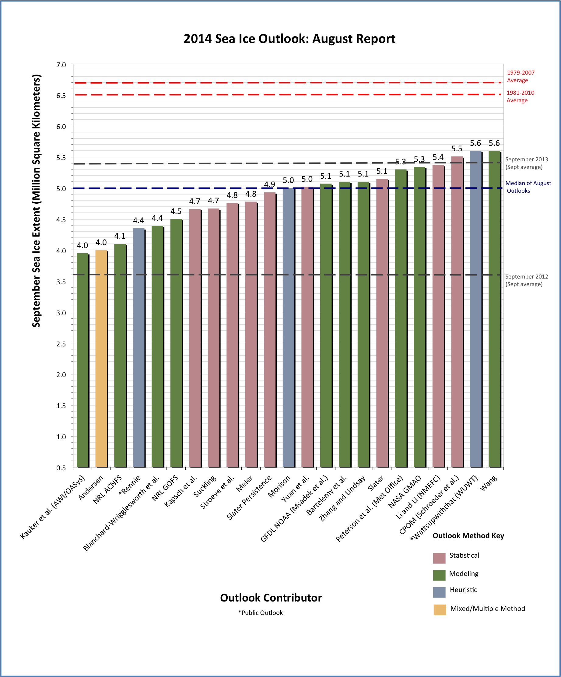
Thank you to the groups that contributed to the August 2014 Outlook. We received 23 pan-Arctic contributions. Of the 23 contributions, some are unchanged from July. The median Outlook value for September extent is 5.0 million square kilometers with a quartile range from 4.58 to 5.22 million square kilometers. The overall range is between 4.0 and 5.6 million square kilometers.(WUWT is at 5.6 along with researcher Wang)
The median value for August is increased from the June and July values of 4.7 and 4.8 million square kilometers, respectively.
This increase reflects the relatively slower decline in ice extent through August than what had been projected earlier. The overall range has narrowed since July, suggesting that the projections are tending to converge, as one would expect with a shorter forecast period. There were four regional Outlooks submitted with a fairly large range in both spatial extent and ice-free dates. There have not been any significant extreme weather events this summer as was seen during the record low years of 2007 and 2012. The more quiet conditions have likely played a role in the evolution of the sea ice extent this summer. While the extent is far from a record low, all contributions will put 2014 as one of the ten lowest September extents in the 36-year satellite record.
The Sea Ice Outlook is a venue for discussion and networking and provides a transparent exercise in both scientific sea ice predictions as well as estimates from the public. The August report was developed by Walt Meier, NASA Goddard Space Flight Center, and the rest of the Sea Ice Prediction Network (SIPN) leadership team, with a section analyzing the model contributions by Francois Massonnet, Université Catholique de Louvain. The report includes comments on modeling outlooks and on regional predictions, a summary of current conditions, key statements from each Outlook, and links to view or download the full outlook contributions. See the original call for contributions for the August report here. Post-season activities of SIPN will provide more of a scientific analysis of the methodologies, relative performance, etc.

Click to magnify the image
Figure 1: Distribution of individual Pan-Arctic Outlook values (August Report) for September 2014 sea ice extent. Labels on the bar graph are rounded to the tenths for readability. Refer to the Individual Outlooks at the bottom of this report for the full details of individual submissions.
Download High Resolution Version of Figure 1.
, July (mid), August (right) 2014 Outlook contributions as a series of box plots, broken down by general type of method. The box color depicts contribution method.")
Figure 2: Distributions of June (left), July (mid), August (right) 2014 Outlook contributions as a series of box plots, broken down by general type of method. The box color depicts contribution
COMMENT ON MODELING CONTRIBUTIONS
Provided by François Massonnet, Université Catholique de Louvain
There were 10 model contributions to the August Sea Ice Outlook. The median predicted September sea ice extent is 5.1 million km² (4.8 and 4.7 million km² for July and June, respectively). From figure 3 below it appears that the uncertainties around individual predictions, when they are updated for this month’s report, are systematically smaller than the ones for July, themselves smaller than the ones for June (see the July report). This confirms our July statement that the later the prediction date, the more confident the predictions. In addition, it becomes clear from the figure that the inter-model spread is also reduced as the prediction start dates get closer to the month of September. The range (max-min) of predicted sea ice extent is 1.65 million km² for the August outlook, 2.03 million km² for July, and 2.6 million km² for June.
We can now put the suite of June-July-August predictions into perspective. Leaving aside the possibility of sampling issues (we have to acknowledge that the number of model contributions is small), it is encouraging first to note that the uncertainty relative to both initial conditions/atmospheric forcing are systematically reduced as time goes by. It is also encouraging to see that the inter-model spread shrinks over time. This spread—which although narrows over the season is still fairly large—reflects the uncertainty in model physics, the differences in spatial resolution, and the differences in coupling formulation across models. Unless these nine models share common systematic biases, it is thus expected that the average 2014 September Arctic sea ice extent will be in the range 3.95-5.6 million km², and likely above the trend line (5.1 million km²), a situation similar to 2013.

Figure 3: Modeling contributions to the July Sea Ice Outlook. June and July contributions are shown in light and medium shading, respectively, for comparison
The full ARCUS sea ice report is here:
http://www.arcus.org/sipn/sea-ice-outlook/2014/august
==============================================================
Full current data can be found at the WUWT Sea Ice Reference Page here: http://wattsupwiththat.com/reference-pages/sea-ice-page/
Stroeve et al. 4.8
…..ROTFLMAO
Don’t you think it’s just a bit early to gloat? Ice movement was pretty quiet up to last week, but it’s picked up a lot. 500k sq kms have been shed against the anomaly.
It’s looking like everyone’s prediction will be under what comes to pass.
My unscientific assessment comes from looking at the current arctic sea ice extent graph and Cryosphere Today’s current display that includes an indication of sea ice thickness. There is only about a month until minimum is reach and there is still a ways to go even to get down to WUWT’s “heuristic” forecast.
The blog NorthwestPassage2014 has a map from the Atlas of Canada on Northwest Passage and expected freeze up dates.
It also shows the Canadian Ice Service map for Aug. 24, 2014
but with great annotation of the key straits and harbors.
http://1.bp.blogspot.com/-LlK6U7GcDd4/U_p1_UguOxI/AAAAAAAAsFY/bxEDwy2Rc30/s1600/20140824180000_WIS38CT_0007832462X.gif
Aug. 25: two vessels are giving up and returning home. Up to twelve vessels known may still be trying, but three are location unknown and two are listed as “will winter over?”
The blog will make excellent reading over the next 3 weeks.
Am I the only person who finds the new typeface difficult to read?
Too many serifs.
(mods, feel free to scrub this OT comment)
The NorthwestPassage2014 blog has a note that two of Canada’s heavy ice breakers are not in the NW Passage, but are on a mission deep in the Arctic doing survey work for Canada in regard to the UN Law of the Sea Treaty.
charles nelson on August 25, 2014 at 4:11 pm
Am I the only person who finds the new typeface difficult to read?
Too many serifs.
I like the new font / typeface, including the wider spacing between letters.
2014 is still coming in slightly higher than 2013 in NSIDC’s daily measurements.
NORTHWEST PASSAGE—The push to find the remains of the Franklin expedition is not simply a matter of historical interest, Prime Minister Stephen Harper said Sunday — it’s about the pre-Canadian claim to sovereignty in the Arctic.
…
Despite Harper’s confidence, the explorers remain concerned about unfavourable ice conditions. Satellite images reveal the Victoria Straight is largely covered in ice flowing up against the western coast of the island.
“Since 2008, we certainly haven’t seen ice anything approaching the coverage that we see this year . . . This is the worst that we’ve seen,” said Ryan Harris, a senior underwater archeologist heading up Parks Canada’s efforts.
http://www.thestar.com/news/canada/2014/08/25/were_going_to_find_franklin_expedition_stephen_harper_vows.html
From the Northwest Passage 2014 blog linked to above …
w.
This is a mess, although I do see the devilish fun in making fun.
But until real money is on the table, on the order of a billion US dollars is laid on the table, I will not lay a bet.
Sorry chumps; and you are Chumps right; you know who you are and you do know that you are a chump; which resolves me from … naming names …. names of the chumps … ha ha.
I carry your secrets well.
🙂
These are predictions to be used for a forecast model? Someone help me out here. Are they treating these predictions as fact in order to forecast further into the future.
Forgive me but it seems to be a case of garbage in, exactly what is anyone expecting to get out of this?
Cheers
Roger
Laugh all you want. I will have the last laugh when MSNBC covers my triumphant arrival by kayak at the North Pole this September. If I don’t lose out to my competition.
With the Arctic ice nearly all gone, I hope I get my press coverage in the middle of all of these North Pole kayakers. Several such expeditions have failed in recent years, but the predictions of ice-free Arctic were just a few years off. This year, I may have a hard time getting my paddle in the water what with all of the other North Pole kayakers.
Where’s the ice-free Arctic prediction gone?
@Phillip Bratby
Put on ice!
Sorry if I’ve missed it above, but which of the graphs on the sea ice page represents what is being measured here? I know it’s sea ice extent but no two graphs have the same values.
SIGINT EX August 25, 2014 at 7:38 pm
Sorry chumps; and you are Chumps right; you know who you are and you do know that you are a chump; which resolves me from … naming names …. names of the chumps … ha ha.
Sophie replied: Sorry, probably because I’m English and may not understand an ‘Americanism,’ but did you mean ‘absolves,’ instead of ‘resolves?’
It’s pretty clearly a misused word, Sophie. Consider the rest of that bizarre post. But I find it funny that you assume that a misused word is an “Americanism.”
The NorthwestPassage2014 blog reports that winds from the east have opened a loooong thin lead. If this counts as a NW Passage opening for 2014, keep this map to show your friends. “Would you pilot your boat through that?”
http://1.bp.blogspot.com/-7H-NboIFiDY/U_-rRehnysI/AAAAAAAAsaA/F5hVHYy9Prk/s1600/20140828180000_WIS38CT_0007839221x.gif
“Follow the thin purple line, he says.”
The Captain provided this list of sailing distances from Bellot Strait that 2km x 25 km channel between Fort Ross and the Franklin Strait. (Bellot Strait is between the E and the U on the Ice Map from 28 Aug above.
Presumably these are the distances following the purple line.
Tuktoyaktuk is the gateway for exploring Pingo National Landmark,
The NorthwestPassage2014 blog says the passage Opened in 2014, on Aug 28-29.
http://3.bp.blogspot.com/-juhBz_r4MeY/VAEbZFvNfLI/AAAAAAAAshA/5HSOAwTEiHc/s1600/20140829180000_WIS38CT_0007840725.gif
It is obvious to me that we need to compile some kind of record of
Which NW Passage routes opened,
in which years,
what was the earliest opening,
and for how many days that year.
In the NorthwestPassage2014 blog, the Captain reports that
Just by the numbers…
21 yachts entered above the Arctic Circle intending a Northwest Passage in 2014.
By August 31, 2014 only 9 yachts remained.
The Northwest Passage opened for 2014 on Aug. 27. But that doesn’t mean you can take the opening for granted.
He tells a story of a tug pulling a salvage barge that was anchored at Fort Ross (East end of Ballot Strait) decided to head westward without first checking for ice in the Bellot Strait.
He shows an excellent sat photo of the conditions in the Bellot Strait (red circle around the ice plug)
http://2.bp.blogspot.com/-QXt29dD3xcE/VAO4jNWuWZI/AAAAAAAAsos/AKRcaoHqDPw/s1600/20140831_BellotStrait_red.jpg
There is also a lengthy section of multi-year ice, including a 2 year animation of ice by age. A lot of it reposted from stevengoddard.
correction: lengthy blog section on the topic of multi-year ice.
The Franklin Strait, the choke point between the Fort Ross / Ballot Strait and the Cambridge Bay traditionally freezes up by September 14 (Atlas of Canada Freeze up of Sea Ice
There have been three days of open passage in 2014 so far, Aug 28, 29, 30. How many more?
The current ice map for Aug 31 shows about 10 miles of 70-90% ice (at about 70.1 N 96.5 W) blocking the one passage that was open. In addition to the ice in the strait, the days are getting shorter and nights longer. Sept 1 has 8.5 hrs of darkness at 70 N which grows to 10 hrs by Sept 11.
The Captain has a long post on Who is Where in the Passage
The key information is that the Bellot Strait is still 9/10 choked with ice and new ice is forming at night. Unless an ice breaker clears the Strait, the NW Passage is already closed.
Bold denotes ships looking to complete a 1 year 2014 Passage as they traversed the Ballot Strait Aug 27-30.
Italics are ships abandoning Passage.
(2013) denotes voyage began in 2013 and wintered over.
Ships westbound west of Bellot – they have 4-6 weeks to make Pt. Barrow (ice 90 miles away)
S/V ARCTIC TERN (at Gjoa Haven bound for Cambridge Bay)
S/V DRINA (through Bellot 8/30. headed for Gjoa Haven. at Ft. Leopold Aug 25)
S/V GJOA (at Gjoa Haven bound for Cambridge Bay)
S/V NOVARA (GBR) depart Cambridge Bay bound for Homer Alaska to winter over “on the hard” (Was at Ft. Ross Aug 25)
S/V GITANA (2013) (est. Sand Point Alaska, Dep. Cambridge Bay prior to Aug 25)
Ships westbound east of Bellot – clock ticking.
TUG TANDBERG POLAR (NO) towing salvage pontoon barge JENSEN (to retrieve Amundsen’s MAUD, sunk 1930 at Cambridge Bay)
Ships eastbound west of Bellot Strait (and currently blocked) – clock ticking.
S/V ALTAN GIRL (CAN) aka ALTAN LADY
S/V EMPIRICUS (USA) (2013) (they reported ice forming overnight) If cannot pass Bellot by 3rd, will head for Gjoa Haven to winter over.
S/V PHILOS (CH) – unknown but est. Gjoa Haven.
M/V TRIDENT ? in Franklin Strait for Bellot.
ROWING ICE (FRA) (row boat) departed Gjoa Haven
Ships eastbound east of Bellot Strait
S/V LADY DANA (POL) in Prince Leopold Sound. (NE of Fort Ross) (in Cambridge Bay Aug 25)
M/V LE MANGUIER (FRA) aka MANGO (2013) at Pond Inlet bound for Newfoundland.
S/V CATRYN (abandoned westbound attempt on Aug 25)
So it looks to me that there are five boats going to complete a 1-year the Passage in 2014.
Westbound:
S/V ARCTIC TERN, S/V DRINA, S/V GJOA, S/V NOVARA (GBR)
Eastbound:
S/V LADY DANA (POL)
Eastbound boats may make it if they can get through the Bellot in a couple of day.
S/V ALTAN GIRL (CAN), M/V TRIDENT
S/V EMPIRICUS (USA) (2013) and M/V TRIDENT have reported traversing the Bellot Strait eastbound.
S/V ALTAN GIRL was waiting for the same conditions and should have traversed, too, but hasn’t reported.
They have to make 380 nmi to Pond Inlet within 30 days before freeze up. With 30% and 40% ice in Leopold Strait, they will be busy.
So that makes three east bound boats making a 2014 1-year NW Passage:
M/V TRIDENT, S/V ALTAN GIRL, and S/V LADY DANA 44.
And 4 boats will complete a 1-year westbound transit.
S/V ARCTIC TERN, S/V DRINA, S/V GJOA, S/V NOVARA (GBR)
If you are going to go on a NW Passage expedition, the M/V TRIDENT has style. A 164 foot, 470 ton, $21 million “megayacht” bought for $11 million.
Scratch S/V GJOA.
They will winter over in Cambridge Bay.
Their’s will be a two year passage.
There was at least one other ice capable passage ship that made the NW Passage westbound.
M/V SILVER EXPLORER: a large 132 passenger vessel. She left Greenland on Aug. 8, must have passed the Bellot Strait about Aug 20, needed Ice Breaker assistance in the Victoria Strait, and got to Nome Alaska on Sept 1.
The M/V BRENNEN was planning and in and out voyage from Greenland to Cambridge Bay. It went west through Bellot Strait on Aug. 25 with an icebreaker and back again on Aug 26, abandoning the leg to Cambridge Bay do to thick ice in Victoria and Peel that even its accompanying icebreaker didn’t want to tangle with.
The M/V L’AUSTRAL is scheduled for 1st week in September with Bellot Strait on Sept 5-6. But I can find no current information on it.
There is a Russian Expedition ship Akademik Sergei Vavilov aka One Ocean Voyager that is a voyage to assist the recovery of the MAUDE and doesn’t look like a NW Passage voyage.
A map of possible routes through the NW Passage.
http://www.canadiangeographic.ca/magazine/apr12/images/northwest-passage-lg.jpg
At the NW Passage blog, the Captain shows a map for “Route 7” which I gather no one has tried.
http://4.bp.blogspot.com/-KgtaXfD00lQ/VAuqdAXVc4I/AAAAAAAAtX4/DqldBP3cS4s/s1600/NWP_Route7.jpg
There is an interactive map from northwestpassage
Weather, ice and details info: http://www.thenorthwestpassage.info/
where by you can see the GPS locations and tracks of the boats
Arctic place markers (anchorages and villages)
links to latest ice information.
and the main 7 passage routes.
Today there is a journal article from the S/V ARCTIC TERN about their visit and exit from Cambridge Bay.
Stephen, thanks for your continued contributions to this topic. Much appreciated.
w.
Today the blog posts three passages back to back.
1. A tale of a man with regrets of a lost family with a last happy memory at Disney World. He remarries and sails the world. Recently they risked life and limb to sail 9000 mi from New Zealand across the Pacific to Alaska, land of the rugged, … and confront in the M/V DISNEY WORLD, A great essay of irony and the ghosts that can haunt you.
2. The Captain gives a summary of pitfalls awaiting the 2016 voyage of the
He reels off a bunch of items on his emergency list. Worth reading.
The Captain has posted elsewhere a quote from Roald Amundsen
“Adventure is just bad planning.”
Amundsen said this, too:
“I may say that this is the greatest factor: the way in which the expedition is equipped, the way in which every difficulty is foreseen, and precautions taken for meeting or avoiding it. Victory awaits him who has everything in order, luck, people call it. Defeat is certain for him who has neglected to take the necessary precautions in time, this is called bad luck.”
3. Then immediately following the post on Serenity, he makes the announcement:
One of Sir Franklin’s 1845 Expedition Ships have been found in the Arctic – HMS EREBUS or HMS TERROR? And follows with what we know of the 1845 Expedition where all hands were lost to starvation, scurvy, and lead poisoning.
The coincidental juxtaposition is worth reflection.
RE: 9/3 2:20 pm
M/V L’AUSTRAL departed on schedule:
Info Received: 2014-08-29 02:35 (last info available free)
Area: Baffin Bay
Latitude / Longitude: 70.24817° / -53.127°
But I can find no news of progress or current position. No blogs, no updates on the lines website.
Just after I posted the “no news of progress”, the Captain posted a report off a Cambridge Bay News facebook page. The L’AUSTRAL on Sept 5 was in Queen Maud Gulf (SE of Cambridge Bay) and beset by ice. The ice breaker did not which to convoy in the dark. So the stop in Cambridge Bay was cancelled.
Got to be like cancelling Christmas for the residents of Cambridge Bay — especially if any cargo destined for them was on board.