IMPORTANT OPENING NOTE
Even if the sea surface temperature anomalies were to remain depressed throughout the 2014 hurricane season (highly unlikely), the actual sea surface temperatures (absolute) from June to November will rise to values capable of spawning hurricanes…a result of the normal seasonal change in surface temperatures. And while El Niño conditions in the Pacific tend to suppress hurricane development by effectively chopping the tops off the developing hurricanes (the result of wind shear in the tropical North Atlantic caused by the El Niño), hurricanes can still form and will likely do so this season.
INTRODUCTION
There are many factors that contribute to hurricane development; one is seasonally elevated sea surface temperature in the tropical North Atlantic.
The hurricane season is approaching fast. With an El Niño developing, it’s likely the predictions for 2014 will be below normal for the season. Of course, the hurricane season will bring alarmist claims of strengthening storms brought on by higher-than-normal sea surface temperatures—the result of manmade global warming—even though, as Roger Pielke, Jr. reminds us, we’re in the longest drought of Category 3, 4 and 5 storms on record.
So let’s take a look at current sea surface temperature anomalies for the Main Development Region (10N-20N, 80W-20W) and the Gulf of Mexico (21N-31N, 98W-81W) as we head into the early part of the season.
And we’ll look at data over three time periods: (1) since January 1854, using NOAA’s Extended Reconstructed Sea Surface Temperature data (ERSST.v3b), (2) since November 1981, with NOAA’s monthly satellite-enhanced Optimum Interpolation Sea Surface Temperature data (Reynolds OI.v2) and (3) since January 1990, using the weekly Reynolds OI.v2 data. To highlight the current values, they are shown as horizontal red lines in each graph. Anomalies are referenced to the period of 1971-2000, which NOAA uses for their Reynolds OI.v2 data.
LONG-TERM SEA SURFACE TEMPERATURE RECONSTRUCTION
The NOAA ERSST.v3b data start in January 1854. Keep in mind, though, that there is less source data for the early periods. For the Main Development Region, April 2014 sea surface temperature anomalies are only 0.11 deg C above the 1971-2000 reference temperatures, while the sea surface temperatures in the Gulf of Mexico are just below “normal”, according to the reconstruction. See Figures 1 and 2.
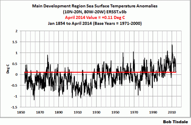
Figure 1
# # # # # #

Figure 2
MONTHLY SATELLITE-ENHANCED DATA
The satellite-enhanced Reynolds OI.v2 sea surface temperature data has a much higher resolution than the ERSST.v3b reconstruction, the latter of which only uses data from buoys and ship inlets. As shown in Figures 3 and 4, the sea surface temperature anomalies for the Main Development Region are effectively “zero”, while in the Gulf of Mexico they’re about -0.1 deg C…that is they’re below the 1971-2000 average.

Figure 3
# # # # # #

Figure 4
WEEKLY SATELLITE-ENHANCED DATA
The weekly satellite-enhanced Reynolds OI.v2 data had showed a slight rebound in recent weeks for the Main Development Region but dropped again last week, while in the Gulf, sea surface temperatures continue to cool. See Figure 5 and 6.

Figure 5
# # # # # #

Figure 6
CLOSING
If and when we have a hurricane or two develop in the months to come, I’ll update the graphs. You’ll likely want some up-to-date graphs to counter the alarmist nonsense. And I’ll include the data for the extratropical coastal waters of the east coast, Sandy’s storm track, since people find it of interest. (See the posts here and here.)
SOURCES
The NOAA ERSST.v3b data are available through the KNMI Climate Explorer and the NOAA Reynolds OI.v2 data are available through the NOAA NOMADS website.
Do we have any idea why there has recently been such a paucity of category three through five storms?
Perhaps there’s only a shortage of land-falling large hurricanes??
Hush! You will wake up the planet!
Nah.
Gore even managed to put a whole bunch of extra wrong-way hurrivcanes on the cover of his propaganda.
But no, ALL of the hurricanes lately have been ID’ed with “official names” and numbered and tracked and publicized even well before they would have ever been noticed in earlier years.
Bob,
Thanks for the update. A bit of a mixed bag but mostly ‘no real trend yet’. Your nuanced insights are truly appreciated!
I have to admit, I’m a bit behind some of the more recent Tisdale updates. Work pressures and life’s normal chaos …. Perhaps this weekend I can play ‘catch up’….
Mac
Okay, all possibilities should be on the table.
Reading an old science book I was astonished at the amount of energy in a hurricane. Presumably when the oceans become warm there are additional hurricanes which then release ocean heat/energy into the atmosphere where it is recorded as a temperature spike?
Has anyone any idea of the TOTAL amount of oceanic energy released each year in this manner and what atmospheric temperature change that represents?
tonyb
Bob, if you’re going to discuss hurricanes, it would be good to have some hurricane data in the article.
There’s annual ACE and also Dr Maue has more detail recent plots IIRC.
I did this a few years ago , it needs updating now.
http://climategrog.wordpress.com/?attachment_id=215
I think Dr Maue’s data shows hurricane energy peaked in about 2005, probably another sign that the current warming is over.
Barclay E MacDonald says: “Do we have any idea why there has recently been such a paucity of category three through five storms?”
While I’m sure there are climate-model-based studies that blame the drought of strong landfalling hurricanes on emissions of manmade greenhouse gases, the answer is no, as far as I know. All weather is chaotic. Hopefully, Ryan Maue will drop by and add to the discussion.
Even with the impending El Nino, I will wager the forecasts will still be for an above average year.
I believe that a study of history would show that this drought is a short term phenomenon and is not unusual. It was the climate obsessed who in 2004 assigned huge importance to the storms of that and the following year. Now that tropical cyclones in the Atlantic hurricane basin have failed to comply with their predictions of doom, they have moved on to other areas to focus their obsessions on.
Bob,
Thanks for including the “Important Opening Note”. Anomalies may be useful for comparisons but, as you point out, actual temperatures are the basis for hurricane development each year. As we in Florida start are annual hurricane prep, once again we live by the creed of hope for the best but be prepared for the worse. It only takes one storm in your area to create havoc in your life.
Isn’t natural variability wonderful?
Check out one of the world’s best hurricane forcasters, Dr. Hansimian.
http://www.nationalcenter.org/HurricaneForecast.html
We never hear or see anything on the West African Monsoon but it also influences the development of Atlantic hurricanes. Anyone know of a site that actively monitors and displays the WAM?
I live near the ocean and I have never seen a hurricane season without a hurricane. I have seen years when the seawater temp was high and few hurricanes were the result.
philjourdan says:
May 14, 2014 at 3:57 am
Even with the impending El Nino, I will wager the forecasts will still be for an above average year.
+++++++++++++++
Thank you philjourdan for using the correct term – average. There is no such thing as “normal” in our climates or weather, just somewhat averaged time periods using arbitrary start and end points (i.e., 30 year average temps used on the nightly weather guesses on TV). If I used the term normal to refer to the reserves in an oil or gas well in a given field I would not be looked on very kindly.
The term “normal” is misused too much in the postings and comments on WUWT and a whole lot of other sites. But as WUWT is the gold standard for this type of blog it should lead the way.
@Bob Alou – Thank you. I try to use the correct terms.
Our forecast, which came out in public on April 8, is here. I think you will find many other later forecasts following it:
http://www.weatherbell.com/2014-hurricane-season-forecast