The title of the post, of course, assumes that an El Niño event will form this year and carry over into the next.
This post is intended for persons new to the topic of El Niño events—and for those who are familiar with them. It should help provide a number of different perspectives on the evolution of an El Niño and supplement our earlier post An Illustrated Introduction to the Basic Processes that Drive El Niño and La Niña Events.
For this post, we’ll primarily be discussing animations of data maps and subsurface cross sections from the NOAA Global Ocean Data Assimilation System (GODAS) website. We’ll also be looking at subsurface temperatures and anomalies from a couple of ECMWF reanalyses. Because there are a number of gif animations, the post may take a few moments to download. Also, you may need to click start the animations, especially if you’d like a closer view.
LOTS GOING ON BELOW THE SURFACE OF THE TROPICAL PACIFIC
If we look at an animation of NOAA GODAS sea surface temperature anomaly maps (Reynolds OI.v2 data), starting in January 2014 and produced at 5-day intervals, we’d be hard-pressed to tell that a moderate to strong El Niño event may be evolving. See the left-hand maps in Animation 1. But when we look at the (right-hand) maps of the subsurface temperature anomalies for the depths of 0-300 meters, we can see that something is happening below the surface. That something, traveling eastward along the equator, has caused subsurface temperature anomalies to increase. That something is called a downwelling Kelvin wave. And, yes, that’s Kelvin wave as in Lord Kelvin.

Animation 1
Kelvin waves along the equatorial Pacific come in two flavors: downwelling (warm) Kelvin waves and upwelling (cool) Kelvin waves. The downwelling and upwelling Kelvin waves generally alternate. The “warm” Kelvin waves are called downwelling because they push the thermocline down, and the opposite holds true for “cool” upwelling Kelvin waves. (I’ll discuss the thermocline is a few moments.) Figure 1 is a Hovmoller diagram from the NOAA weekly ENSO update dated March 31, 2014. (See their page 16.) Don’t be intimidated by the Hovmoller. It is a wonderful way to present data. The left-hand (y) axis is time (a year), with the most recent week at the bottom. The bottom (x) axis presents the longitudes of the equatorial Pacific. South America would be to the right and Indonesia to the left. The subsurface temperature anomalies (for the top 300 meters) are color-coded with warm anomalies in red and cool anomalies in blue. The dashed lines highlight the (warm) downwelling Kelvin waves and the dotted lines highlight the (cool) upwelling Kelvin waves. Since August of 2013, there have been 3 (warm) downwelling Kelvin waves and 2 (cool) upwelling Kelvin waves. The first two downwelling Kelvin waves in the Hovmoller were relatively weak, and they occurred a little late in the 2013 season, so they did not result in an El Niño event. The most recent downwelling Kelvin wave is a reasonably strong one, and it’s at the right time of the year, leading to the thoughts that a strong El Niño will form this year.

Figure 1
Cross sections of subsurface temperature anomalies along the equator are presented in Animation 2. From this perspective, it’s as if they sliced the Earth open at the equator and we’re viewing the temperature anomalies of the equator below the surface, looking toward the north. Again, these cross sections are available from the NOAA GODAS website. The Pacific is in the center cross section (with the Indian Ocean to the left, and the Atlantic to the right). The vertical axis is depth. The vast majority of El Niño- and La Niña-related processes take place in the top 300 meters (984 feet). Also keep in mind that the Pacific stretches more than 17,000 km (about 11,000 miles), almost halfway around the globe, at the equator. In other words, the distances and depths are not proportional in those cross sections and can’t be if they’re going to be informative.

Animation 2
Notice how the subsurface temperature anomalies grow stronger along the equatorial Pacific as the Kelvin wave travels east. That’s because the climatology (the average reference temperatures from which the anomalies are calculated) has cooler temperatures in the eastern equatorial Pacific. As an example, see the annual GODAS climatology for those subsurface temperatures in Figure 2.

Figure 2
I was hoping to animate the Kelvin wave working its way east using absolute temperatures, not anomalies, just to give you a better idea of what’s taking place. Unfortunately, as far as I know, GODAS only has cross sections using anomalies; that is, they do not also present the subsurface temperatures in absolute form. And the latest month of the ECMWF ORA-S4 Reanalysis is February 2014, so that wouldn’t be very helpful to us now.
Luckily, somewhere along the line, I created an animation of subsurface temperature data (anomalies and in absolute form) of the 1997/98 El Niño, using cross sections available from an earlier ECMW reanalysis. Animation 3 presents the ECMWF subsurface cross sections from December 1996 to April 1997 as anomalies (top cell) and in absolute form (bottom cell). This is just a small portion of the original animation.
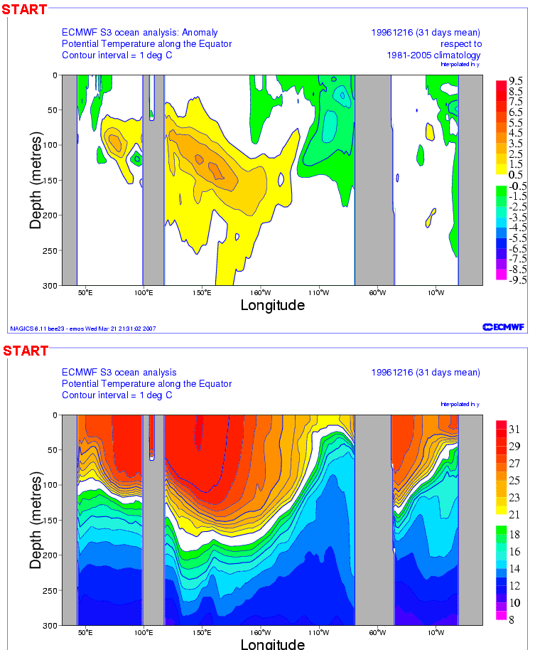
Animation 3
We can see the anomalies working their way eastward in the top cell of Animation 3 as the Kelvin wave(s) travels east. (See the note below.) In the bottom cell of Animation 3, we can see how the Kelvin waves depress the thermocline, as they travel east. I suspect the little rebound we see halfway through in the lower cell occurred between the 2 Kelvin waves.
Note: There were actually 2 downwelling Kelvin waves that preceded the 1997/98 El Niño. See the portion of a JPL sea level residual animation here. The first downwelling Kelvin wave that started around Christmas of 1996 appears to have had little effect, but the second one a couple of months later definitely started the ball rolling. [End of Note.]
Recall earlier that we noted that a downwelling (warm) Kelvin wave pushes down on the thermocline. The thermocline is the boundary between the mixed waters (nearer the surface) and deep ocean waters. The thermocline (20 deg C) is highlighted in white in the lower cells of Animation 3.
WHAT INITIATED THE KELVIN WAVE THIS YEAR?
We recently discussed Westerly Wind Bursts in the post ENSO Basics: Westerly Wind Bursts Initiate an El Niño. The start of the 2014/15 El Niño (assuming it continues to form) is another classic example. See Figure 3. Two apparent westerly wind burst-like shifts in the zonal (east to west) winds can be seen in the left-hand Hovmoller diagram from GODAS. That is, the trade winds, which normally blow from east to west, suddenly and temporarily shifted to westerlies, blowing from west to east. I’m sure someone will eventually explain in a paper what weather event caused the westerly wind bursts.
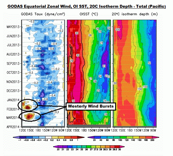
Figure 3
THE KELVIN WAVE ISN’T VERY HIGH BUT IT SURE IS LONG
Without the magic of satellite altimetry, it would be impossible to sense the equatorial Kelvin wave as it traverses the Pacific from west to east. It’s incredibly long, but not very high. In Animation 4, the GODAS maps of sea level anomalies are on the left, and the maps of subsurface temperature anomalies for the top 300 meters are on the right.

Animation 4
As of March 29, the sea level anomalies map (Figure 4) is showing a positive anomaly of between 10 and 15 cm (about 4 to 6 inches) at the greatest contour levels along the Kelvin wave, and based on the 5 cm contour line, it stretches from about 165E to about 95W or about 11000 km (about 6900 miles). (See the NOAA Latitude-Longitude Distance Calculator.)

Figure 4
The processes taking place in the Pacific when an El Niño develops are enormous in scale.
AN INTERESTING PERSPECTIVE FROM ECMWF
The ECMWF ORA-S4 reanalysis also presents cross sections of average subsurface temperatures but on what they call a “YZ” perspective, which is as if they took large slices of the Pacific ocean running south to north and we’re viewing the average temperatures and anomalies facing west. Figure 5 shows the west and east Pacific coordinates they’re illustrating in the YZ plots.

Figure 5
The February 2014 reanalysis of the West Pacific (50S-50N, 130E-160W) subsurface temperature anomalies (left) and subsurface temperatures (right) are shown in Figure 6. South is to the left, north to the right and the equator is in the middle. The vertical axis is depth. The temperature scales are below each plot. The positive subsurface temperature anomalies associated with the downwelling Kelvin wave appear below the equator in the left-hand cell. The pocket of positive anomalies below the surface at about 10N should be the remnants of the downwelling Rossby wave returning the warm water to the west from an earlier downwelling Kelvin wave. I’ve included the plot of absolute temperatures on the right simply to put things in perspective.

Figure 6
The East Pacific (50S-50N, 160W-90W) subsurface temperature anomalies (left) and subsurface temperatures (right) for February 2014 are shown in Figure 7. The Kelvin wave hadn’t made it far enough to the east in February to make its presence known in these plots. In the right-hand cell of Figure 7, note how the warmer water does not reach as deep in the eastern Pacific as it does in the western Pacific shown in Figure 6. The trade winds push the warm water to the west where it “piles up”. The trade winds also help to draw cool water to the surface along the equator in the eastern Pacific in a process called upwelling.

Figure 7
NINO3.4 REGION SEA SURFACE TEMPERATURE UPDATE
The NINO3.4 region is bordered by the coordinates of 5S-5N, 170W-120W. See the illustration here for the location. The sea surface temperature anomalies there are a commonly used index for the strength (how warm or cool), frequency (how often they occur) and duration (how long they last) of El Niño and La Niña events. Based on the weekly Reynolds OI.v2 data for the week centered on April 2, 2014, the NINO3.4 sea surface temperature anomalies are presently at +0.38 deg C, which is below the +0.5 deg C threshold of El Niño conditions. See Figure 8.

Figure 8
Figure 8 is from the (most recent) March 2014 sea surface temperature anomaly update.
Hopefully, this post has helped to show how ridiculous it is to think that an ENSO index represents the processes of ENSO.
FUTURE POSTS
I’ll be updating the animations in future posts. I’ve downloaded the maps and cross sections so that I can add on the new ones to the ends of what has already been presented. (GODAS only animates for 3 months.) That way we can track the warm water, and continue to follow it during the La Niña that’s sure to follow.
I don’t believe I can establish a schedule for these posts. But I will update when something interesting happens that will help confirm the processes of El Niño discussed in An Illustrated Introduction to the Basic Processes that Drive El Niño and La Niña Events. Maybe I’ll prepare the next one when the NINO3.4 sea surface temperature anomalies cross the threshold of an El Niño and reach a reasonably warm value and when the trade winds in the western tropical Pacific reverse and become westerlies. We’ll see what happens.
Please feel free to suggest/request topics for upcoming posts.
ADDITIONAL READING
I went into much more detail to explain ENSO processes and the aftereffects of El Niño and La Niña events in my ebook Who Turned on the Heat? I’ve lowered the price of Who Turned on the Heat? from U.S.$8.00 to U.S.$5.00…with hope of increasing sales a little bit. A free preview in pdf format is here. The preview includes the Table of Contents, the Introduction, the first half of section 1 (which was provided complete in this post), a discussion of the cover, and the Closing. Take a run through the Table of Contents. It is a very-detailed and well-illustrated book—using data from the real world, not models of a virtual world. Who Turned on the Heat? is only available in pdf format…and will only be available in that format. Click here to purchase a copy. Thanks.
CLOSING COMMENT
It is unfortunate that NOAA budget cuts have resulted in reduced operation of the Tropical Ocean-Atmosphere (TOA) Project array of moored El Nino-monitoring buoys. See the Nature editorial Support our buoys. I understand from a follow-up Nature article El Niño tests forecasters that NOAA has “committed” to having most of the system operational by the end of the year, but, unfortunately, by that time, the El Niño will be near or at its peak intensity. I find it quite remarkable that federal budget cuts have caused the partial demise of such an important system. The array should not have been left to decay; it should be expanded to cover the entire tropical Pacific, not just the latitudes of 10S-10N, because El Niño- and La Niña-related processes take place within the tropical Pacific but outside of the latitudes presently being monitored by the TAO project. NOAA should be increasing, not decreasing, the budget of the Pacific Marine Environment Laboratory.
For anyone who hasn’t read Bob’s book, I can highly recommend it. I can speak knowledgeably about ENSO to anyone who wants to listen.
Thanks, Susie.
If an interruption of the westerlies could be caused by a weather event and trigger an El Niño, could a weather event then strengthen the westerlies and kill it off early?
Nice overview. But, SST’s off the coast
of South America & Peru continue to cool and expand in early April. Similar
conditions happened last year. Also, the PDO phase is unchanged. I’m personally not yet convinced there will be an El Niño in 2014.
Bloke down the pub says: “If an interruption of the westerlies could be caused by a weather event and trigger an El Niño, could a weather event then strengthen the westerlies and kill it off early?”
Just the opposite. If the sea surface temperatures increase in the eastern tropical Pacific in the next few months in response to the Kelvin wave (and they should), the trade winds (blowing east to west) in the western tropical Pacific should weaken and then become westerlies (blowing west to east). That will help to push more warm water from the west Pacific Warm Pool into the Eastern Tropical Pacific. The equatorial countercurrent (west to east) engorges at that time. That positive feedback helps to reinforce an El Nino.
Could a weather event keep the trade winds in the western tropical Pacific from reversing, becoming westerlies, and providing that positive feedback? I guess it’s possible. Trade winds like all winds are fluky. But I wouldn’t count on it.
Gotta go to work. Be back at lunchtime and this evening.
Regards
Bob, probably a dumb question, but are the PDO and ENZO related and if so how?
Not that the Pacific ocean cares, but I can’t decide what to root for. A weak el nino in the context of a cold pdo likely means another very cold winter in the eastern and southern U.S. Thanks but no thanks. A strong el nino might mean a warmer winter, though stormy/cool in Florida next winter, which is where I’m headed Jan-April 2015. Also, a strong el nino might well temporarily end the pause. Again, thanks but not thanks.
I guess no el nino would be the best option from my selfish point of view. So there. All worked out 🙂
what does this mean. ” at a high level ” if my heater stays on at a higher level my room stays a higher temp.
http://www.space.com/2942-sun-activity-increased-century-study-confirms.html
“During the last few decades, the solar activity is not increasing. It has stabilized at a high level, but the Earth’s climate still shows a tendency toward increasing temperatures,” Usoskin explained.
Some would say “impossible” – until it happened. Our esteemed Dr. Bob says it is possible, just that he has not observed it. That is why I regard him highly.
I actually get a lot out of his comments as more often than not, others are asking the same questions I have. I will be sure to read these El Nino articles.
The little child will hopefully bring much needed Fall-winter precip to Texas, the SW US, and California.
Can recommend ‘Who Turned on the Heat.’ With its explicit visual presentation and
clear recaps even a serf gets it.
Bob Irvine says: “Bob, probably a dumb question, but are the PDO and ENZO related and if so how?”
Not a dumb question at all. It’s asked all the time. And I answer it all the time, but a little differently each time with hope of making it easier to understand.
Here’s my latest effort. It’s from the draft of a blog post I wrote a couple of weeks ago, but never got around to posting:
The PDO is an aftereffect of ENSO. The PDO Index does not represent the sea surface temperature of the North Pacific, north of 20N, where it’s derived. The PDO index represents the spatial pattern of the sea surface temperatures in the North Pacific.
That is, an El Niño event in the tropical Pacific creates a spatial pattern in the North Pacific where it’s warmer in the eastern North Pacific than it is in the western and central North Pacific. That El Niño-related spatial pattern shows up in the PDO index as a positive value. The actual sea surface temperatures of the North Pacific can rise and fall, but just as long as the spatial pattern remains fixed (warmer in the east and cooler in the west and central North Pacific) the PDO index would remain at a constant positive value. While it’s not determined this way, sometimes it’s easier to think of the PDO as a temperature difference between the eastern North Pacific and the western and central North Pacific.
On the other hand, a La Niña event in the tropical Pacific creates a spatial pattern in the North Pacific where it’s cooler in the eastern North Pacific than it is in the western and central North Pacific. And that La Niña-related spatial pattern shows up in the PDO index as a negative value.
A PDO index value of zero indicates neither of those El Niño-related or El Niño-related spatial patterns exist.
The reason that the PDO does not mimic an ENSO index exactly is because the spatial pattern in the North Pacific is also affected by the wind patterns (and corresponding variations in sea level pressure) there.
# # # #
For more info on what the PDO represents, and, more importantly, what it doesn’t represent, see the following posts:
http://bobtisdale.wordpress.com/2010/09/03/an-introduction-to-enso-amo-and-pdo-part-3/
And:
http://bobtisdale.wordpress.com/2010/09/14/an-inverse-relationship-between-the-pdo-and-north-pacific-sst-anomaly-residuals/
Regards
Does a reasonably strong El Nino (such as we might be seeing develop now) always and necessarily lead to an uptick in global surface temperatures? Is the rise in global surface temps immediately apparent or is there a lag of some months?
Thanks.
Bob Tisdale says:
April 8, 2014 at 4:17 am
Gotta go to work. Be back at lunchtime and this evening.
Regards
______________________
Another obvious case of the Koch Bros. check being in the mail.
In terms of weather events in the Western Pacific stopping El Nino in its tracks, don’t bet on it. A northern hemisphere typhoon circulates anti-clockwise, so the southern side of the circulation blows from west to east, which would aid the winds that reinforce El Nino. A southern hemisphere cyclone circulates clockwise, so the northern side of the circulation also blows from west to east.
Another great lesson from Bob Tisdale. Thanks again, you have the clarity of ten ordinary men! Present the data and explain what it says and what it doesn’t say.
No SWAGing in support of a pet theory, just science at its best.
KRJ Pietersen, the time lag between the major changes in the sea surface temperatures of the equatorial Pacific (NINO3.4 region) and the response in global surface temperatures is a few (3 to 4) months. For lower troposphere temperature anomalies, it’s about 5 to 6 months.
Regards
Alan Robertson says: “Another obvious case of the Koch Bros. check being in the mail.”
I think people thought my open letter to the Koch brothers was a joke:
http://bobtisdale.wordpress.com/2013/10/15/open-letter-to-the-koch-brothers/
It wasn’t. I’d be happy to have a sizeable contribution from them so that I could go back to blogging full time.
Regards
KRJ Pietersen says: “Does a reasonably strong El Nino (such as we might be seeing develop now) always and necessarily lead to an uptick in global surface temperatures?”
Sorry about not replying to the initial question. The answer is yes. The only time an El Nino doesn’t show up in the global temperature record is when the El Nino is counteracted by the aerosols from a strong explosive volcano. Example: the 1982/83 El Nino and the eruption of El Chichon in 1982.
Too early to call. MJ will be the time to decide.
Excellent post Bob. Very well presented and should help many who are relatively new to the discussions here grasp what you have written in the past. I gained from it and I’ve been following you for several years.
You are now tracking, in a sense, what Willis has been doing and making it clear what you are showing. I don’t think anyone will mind reading over something that has been covered much more deeply in previous posts. The more we/they understand the better we will be able to follow in future posts.
Good work. Thank you.
Very nicely presented Bob. Very interesting and informative. Particularly adding real temps is a help.
It’s worth noting that the West Pacific warm pool exists because of the coreolis effect causing the major ocean gyres in both hemispheres to run east-west. The gradient show in the climatology in figure 2 is primarily a result of oceanic coreolis circulation. The same pattern is seen in the Atlantic.
Once this temperature difference is established it creates the trade winds which reinforce it. Variations in the trade winds could modulate it but they don’t cause it.
Bob Tisdale says:
April 8, 2014 at 8:11 am
Bob Tisdale says:
April 8, 2014 at 8:15 am
Many thanks Bob.
Superb Bob and I shall purchase your ‘book’ today. Now as a forecaster my quick response to your query on ‘westerly wind bursts’ is fairly simple. The term is a cutesy one that can reflect the annual Monsoon winds that start from the High Pressure Cell over southeastern Asia. The stronger the central pressure of the cell the stronger the outflow. These winds seek lower pressure with the equatorial region being a primary choice. The winds cross the equator, turn left or eastward and form the basis of the annual monsoon. Some years strong, some not so strong, but they peak in the height of the southern summer because that is when the Asian High is strongest.
The other cause of ‘westerly wind bursts’ is the MJO; a moving pulse of convection starting in the Indian Ocean and travelling east at about 5mps or around 10 knots. Again the MJO is most active in the southern summer and takes about 40-60 days to circumnavigate the globe. The rain events and westerly winds that comprise the pulse can be quite boisterous, enhance the SPCZ, contribute to the formation of Tropical Depressions, etc.
The other cause of westerlies along the equator are from travelling Northern Hemisphere High Pressure Cells moving west to east. Again these winds which are the NE trades in that hemisphere, turn left when crossing the equator and become a variant of ‘westerlies’. These are TRANSIENT westerlies as are those of the Monsoon and MJO.
I have been forecasting for the tropics for the last 10 years and have never seen prolonged periods of west winds. I talk frequently via HF radio with Tuna fishermen that fish between 5S and 30S and I can assure you they would laugh at that notion. Anyway, great post and I look forward to the next instalment.
Cheers.
I was kind of hoping for a prediction type conclusion to the post. Will there or won’t there be an El Nino and if there is, will it it be big enough to see an effect on global temperatures. I’m hoping not. Or will the El Nino fail to arrive.
I now see that the title says “Part 1”. So a prediction in the conclusions of “Part 2” perhaps ?
It’s interesting to note that the size of the Kelvin wave heading for the west coasts of North and South America is comparable to global SLR attributable to AGW (ie since 1950). We can logically be concerned about SLR in the distant future, but there is no reason to be more alarmed about either right now. The normal “tilt” of the Pacific enhances the possibility of hurricane damage in the West Pacific, where the risk of hurricane damage is greatest.
J Martin says: “I was kind of hoping for a prediction type conclusion to the post. Will there or won’t there be an El Nino and if there is, will it it be big enough to see an effect on global temperatures.”
My assumption behind all of my recent ENSO posts is that there will be an El Nino this year, and it will have an impact on global surface temperatures. The question I have is, will the El Nino be strong enough to create an upward step in the sea surface temperatures of the Atlantic, Indian and West Pacific Oceans (aka a Trenberth “big jump”)?
Many thanks to all who purchased a copy of “Who Turned on the Heat?”!!!!!
Cheers.
I would not bet on it, it’s almost like tossing a coin. There are too many variables involved in weather patterns, solar activity, jet streams, ocean currents. I am no expert I admit, but there many patterns that we can’t control.
Bob, I followed the link An Illustrated Introduction to the Basic Processes that Drive El Niño and La Niña Events to your website and found it very informative. I have read/heard about the Ninos most of my life and only now understand it all. I recommend that anyone who wishes to understand the process do the same.
Hey Bob, if you need more adjectives (and some action verbs) in your essays, perhaps you can borrow some from http://robertscribbler.wordpress.com/2014/03/25/monster-el-nino-emerging-from-the-depths-nose-of-massive-kelvin-wave-breaks-surface-in-eastern-pacific/ e.g.
By 2013, this hot water pool had grown into a vast abyss of heat. Cyclones forming over this zone experienced a kick in intensity as the typical upwelling force of their winds only dredged more hot water from the ocean deeps. It was a pattern that is contrary to typical tropical storm dynamics in which cooler waters drawn up by intense storms tend to limit their peak strength. Not so with mega-typhoon Haiyan, the strongest storm ever to strike land. The cyclonic wind pattern only dredged more heat from the extraordinarily deep hot water. And so the storm only grew stronger and stronger, knowing little in the way of limits before it barreled into an already storm-battered Philippines.
And as the trade winds fell and reversed due to this sporadic assault of countervailing storms, the hot, deep pool of water surged eastwards. To those on the surface, the motion was invisible. And but for a series of floats spread throughout the Pacific, we would never know a monster thing was rushing along toward the east at a depth of about 150 meters below.A Rising Monster
Pushing the Tip of Its Nose up in the Eastern Pacific
As growers and states with marginal or bad food security grew more anxious, the hot water surge intensified. Researchers independent of NOAA began to issue estimates for a 60, 70 even 80% probability for the emergence of El Nino. Others, tracking what now appeared to be the hottest Kelvin wave ever seen, began to issue warnings that a monster event may well be on the way.
Ric Werme says: “Hey Bob, if you need more adjectives (and some action verbs) in your essays, perhaps you can borrow some from…”
Wow.
Hey,
I’ve just read an article that you might really like. You won’t regret, please read it here
Thx, gerjaison