
Image Credit: Bob Tisdale – bobtisdale.wordpress.com
By WUWT Regular Just The Facts
The recent Adjustments/Corrections to the HadCRUT4 and CRUTEM4 Temperature Data Sets by the Met Office Hadley Centre and Climatic Research Unit got me thinking about the cumulative impact of Adjustments/Corrections on our temperature records. Bob Tisdale then triggered the first vein of this analysis when he recently produced and provided the graph above, which compares the ICOADS (International Comprehensive Ocean-Atmosphere Data Set) v2.5 data set to HadSST3, HADISST and ERSST.v3b. ICOADS is the original unadulterated Sea Surface Temperature record. HadSST3, HADISST and ERSST.v3b, all include adjusted/corrected ICOADS data, e.g.:
[Note: Bold and non-link underlines below are mine. I am testing out a new three speed review approach, i.e. if you really want to know it, read it all, if you want an overview, read the underlines and non italics, if you want the key concepts, read the bold and non italics. Please let me know in comments if this approach works for you.]
HadSST3 The SST data are taken from version 2.5 of the International Comprehensive Ocean-Atmosphere Data Set, ICOADS (external web page), from 1850 to 2006 and on GTS observations from 2007 onwards. HadSST3 is produced (a slightly more detailed description) by taking in-situ measurements of SST from ships and buoys, rejecting measurements that fail quality checks, converting the measurements to anomalies by subtracting climatological values from the measurements, and calculating a robust average of the resulting anomalies on a 5° by 5° degree monthly grid. After gridding the anomalies, bias adjustments are applied to reduce the effects of spurious trends caused by changes in SST measuring practices. The uncertainties due to under-sampling and measurement error have been calculated for the gridded monthly data as have the uncertainties on the bias adjustments following the procedures described in the paper.
The HadSST3 page references this paper “Improved Analyses of Changes and Uncertainties in Sea Surface Temperature Measured In Situ since the Mid-Nineteenth Century: The HadSST2 Dataset“, Rayner, et al., 2005, as the basis for their adjustments/corrections. It states within that:
a. Bias correction and its uncertainties Seawater has been sampled for temperature measurement on board ship by various different means at different times. This change from using insulated (wooden) to uninsulated (canvas) to partly insulated (rubber) buckets, engine room intakes, and hull sensors, along with changes in ships speeds, has introduced changing relative biases into the database. Folland and Parker (1995) developed corrections to be applied to SST data between 1856 and 1941 to ameliorate the effect of these changes and to bring the older data into line with data from the modern mix of measurement methods. For details of the development of these corrections, the reader is referred to Folland and Parker (1995).
Here’s Parker, Folland, M. Jackson (1995) paper MARINE SURFACE TEMPERATURE: OBSERVED VARIATIONS AND DATA REQUIREMENTS Here are some of the adjustments/corrections detailed within:
“Overall global warming in SST between the 1860s and the 1970s is about 0.3 °C greater in the present analysis than in Folland et al. (1984), mainly owing toreduced early corrections applicable under the assumption of the predominant use of wooden buckets (Section 3).”
“The largest, positive corrections are in early winter (December) over the Gulf Stream and the Kuroshio, where warm water, cold dry air, and strong winds cause rapid evaporative heat loss from the buckets. The corrections approach 1 °C by 1940 in these regions in early winter. Corrections are also large (around 0.4 °C to 0.5 °C by 1940) in all seasons in the tropics because of the high rate of evaporation when SST is high. Some negative corrections are made in mid latitudes in summer, mainly where the mean air temperature around the bucket exceeds the mean SST.”
Here’s their Figure 7, which shows the impact of their adjustments/corrections.
“How do we know that these corrections are trustworthy? The agreement of SST anomalies with largely independently corrected NMAT anomalies (Section 7 and Figure 7) is the strongest support to the results, and suggests that the impacts of future refinements and reduction of uncertainties in this area will be small.”
So who do you think provided the “largely independently corrected NMAT” SST anomalies, which are “the strongest support to the results”? Wait for it…
“Folland et al. (1984) applied corrections to NMAT to compensate for the historical increases of the average height of ship’s decks. These rose from about 6 m before 1890 to 15 m by the 1930s and 17 m by the 1980s. The corrections, based on surface layer similarity theory, removed a spurious cooling of about 0.2 °C between the late nineteenth century and 1980. On the other hand, Jones et al. (1986) used anomalies (not actual values) of regional, mainly coastal, land surface air temperature to adjust anomalies of nearby MAT. This was possible because anomalies of MAT and nearby ‘coastal’ land surface air temperature are found to be similar in recent data over periods as long as a decade, even though the absolute values differ considerably. However, because Jones et al. (1986) used COADS summaries, they were unable to separate NMAT from day MAT which are affected by historically varying, on-deck solar heating: their corrections therefore differed from those of Folland et al. (1984). In both these early studies, about 0.5 °C was subtracted from MAT for 1942-5, a period of non-standard measurement practices owing to war. “
Yes, that Jones et al. (1986) reference is Phil Jones, and Tom Wigley too, at the Climatic Research Unit (CRU), University of East Anglia (UEA). And it turns out that Rayner, Folland and Parker all worked at the Hadley Centre, Met Office.
This 1992 Jones and Wigley paper “Corrections to Pre-1941 SST Measurements for Studies of Long-Term Changes in SSTs” appears to be a seminal work in the development of Sea Surface Temperature record adjustments/corrections:
Many factors can influence a sea surface temperature reading (Barnett, 1985; Jones et al., 1986; Bottomley et al., 1990; Jones et al., 1991). Some of these introduce random errors while others result in systematic, non- cancelling errors. The most important factor is the method of collecting the sample, with the two basic methods being to haul a sample on deck with a bucket, or to measure the temperature of the intake water used for engine cooling. Here, we are concerned with bucket measurements. These are affected by the kind of bucket used, the exposure of and physical conditions surrounding the bucket, how long the bucket was left before reading the thermometer, and ship speed.
In COADS we do not have detailed information concerning the methods of measurement, nor any indication of what method was used for the individual readings that make up the data. There is,nevertheless, strong evidence that readings before 1940 were predominantly bucket measurements, while those since 1945 were predominantly intake measurements (Jones et al., 1986). Furthermore, it is likely that the major difference between the data for these two periods is the non-climatic bias due to the evaporative cooling of the canvas bucket, an effect which would clearly cause pre-1940 data to be cooler than post-1945 data (Jones et al., 1991).
In order to derive correction factors for the bucket-derived temperatures, we have modified the model developed by Folland and Hsiung, 1987 and Bottomley et al., 1990, to estimate the cooling of an uninsulated canvas bucket. The main difference between our work and that of Folland and Hsiung (1987) is that we have solved the governing equations analytically. This makes application of the model less demanding computationally, and it allows us to perform a variety of analyses.
2. The bucket model
If you have not already, you really should take a look at Section 2. “The Bucket Model” within Jones and Wigley’s 1992 paper, as it is a classic work in gibberish…
Continuing…
4. Correcting SSTs using the bucket approach
4.1 Optimum exposure time
For 1905-40, SSTs may be corrected using the evaporating bucket model. Although average ship speed probably varied over this period, within the range of likely values ship speed does not noticeably affect the implied exposure time. We have used a ship speed of 7ms-1. Wind speeds of 60% of the anemometer speed produce slightly better results than the 40% reduction case, and lead to slightly lower optimum exposure times (by less than 1 minute on average) so we have used this value. As the most likely exposure time lies in the range 3-6 minutes, we use 4 1/2 minutes in making final corrections.”
“4.2 The final correction factors
Final correction factors depend on the location, month and year. These variations are summarized in Figures 3 to 5. Correction factors vary slightly from year to year depending on coverage changes. Figure 3 shows mean correction factors for the Northern Hemisphere. Southern Hemisphere mean corrections are shown in Figure 4. The transition from small corrections in the early decades to larger corrections after 1905 is due to the change from wooden (i.e., better insulated and assumed to require no correction) to un-insulated buckets. Correction factors are largest in the winter half year. Northern Hemisphere corrections show slightly larger season-to-season variations. Figure 5 shows how the “winter” (JFM) and “summer” (JAS) – using Northern Hemisphere seasonal labels – corrections vary with latitude. Correction factors are lower in higher latitudes in general, particularly in the 45-75°N band where the “summer” corrections are near zero.”
It appears that the Team that brought us Climategate, was hard at work adjusting/correcting the Sea Surface Temperature record back in the 80s and 90s…
Here Jones and Briffa team up to summarize the purported basis of the Sea Surface Temperature record adjustments/corrections in their paper, “Global Surface Air Temperature Variations During the Twentieth Century: Part 1, Spatial, Temporal and Seasonal Details“, P. D. Jones and K. R. Briffa, 1992.
“Problems with the homogeneity of sea surface temperature (SST) data arise due to differences in the method of sampling the sea water. Before the second world war the sea water was collected in an uninsulated canvas bucket. There was a delay of a few minutes between sampling and measuring the temperature. During this time the water in the bucket generally cooled slightly by evaporative means. Since the second world War most readings have been made in the intake pipes through which sea water is taken onboard ships to cool the engines. This change in measurement technique was quite abrupt at around 1941, although there are still significant numbers of bucket measurements (using plastic and thus better insulated buckets) made today and some intake measurements were made prior to the second world war.
Comparative studies of the two methods indicate that bucket temperatures are cooler by 0.3-0.7″C (James and Fox, 1972). Correcting the SST data for this measurement change may seem, at first, seem an intractable problem. Folland and Parker (1990; 1991) of the UK Meteorological Office, how- ever, have developed a method for correcting the canvas bucket measurements based on physical principles related to the causes of the cooling. The cooling depends on the prevailing meteorological conditions, and so varies according to the time of year and location. Although the cooling is therefore a day-to-day phenomenon, the various influences are basically linear, so cooling amounts can be calculated on a monthly basis. The main free parameter is the elapsed time between sampling and reading. This is generally unknown and must be estimated from the data. The primary assumption in this estimation is that there have been no major changes in the seasonal cycle of SSTs over the period of record. Since the amount of evaporative cooling has a strong seasonal cycle in many parts of the world, an optimum exposure time can be chosen; namely that which minimizes the residual seasonal cycle in the corrected data.As a check on the validity of the method, the implied optimum exposure time turns out to be quite consistent spatially (see Jones and Wigley, 1990; Jones et al., 1991 for more details).
The major problem with the technique is that it is not known with any certainty what types of buckets were used to take measurements during the nineteenth century. Assuming canvas buckets rather than wooden buckets (which are better insulated) leads to corrections which infer SSTs warmer than land temperatures by about 0.2″C. The discrepancy almost disappears if wooden buckets are assumed. Although there is documentary evidence to support wooden bucket use during the mid-nineteenth century, considerable doubt remains about the transition from wooden to canvas buckets. The seasonal-cycle elimination method is not precise enough to choose between the two possibilities. The corrections used here have been derived using the wooden bucket assumption in the nineteenth century (see Jones et al., 1991 for details).
“The major problem with the technique” and “The Bucket Model” are that they rely upon an array of assumptions and estimations, which are based on very limited empirical data, and were made by people like Phil Jones and Tom Wigley, who have apparent biases, and appear to have been working the propagate the Catastrophic Anthropogenic Global Warming narrative since the early eighties. It is interesting to note that the Jones et al. papers on Sea Surface temperature adjustments/corrections do not appear listed within the otherwise quite encompassing collection of Jones’ work on the UEA website.
Steve McIntyre has written extensively about bucket adjustments starting back in 2005, i.e. Changing Adjustments to 19th Century SST;
You may recognize Folland as a major IPCC author (Folland et al. [2001] is sometimes the citation). SST sampling is not homogeneous – it changed from buckets to engine inlets – engine inlet temperature ran a little hotter. Both canvas and wooden buckets appear to have been used. There are millions of SST measurements and how the measurement was done is not known for most measurements (as far as I can tell.) There are two main adjustments in Folland et al. The first is a one-time adjustment for from buckets to engine inlets in December 1941. This is premised on a comparison between the “corrected” NMAT temperature [ I haven’t checked what these “corrections” are] and the uncorrected SST temperatures.
Buckets and Engines, The Team and Pearl Harbor, Bucket Adjustments: More Bilge from RealClimate, Rasmus, the Chevalier and Bucket Adjustments, Did Canada switch from Engine Inlets in 1926 Back to Buckets?;
CA readers are aware that I discussed bucket adjustments on a number of occasions long before Thompson et al 2008, in particular, questioning the absurd IPCC assumption that all SST measurements switched from buckets to engine inlet on the day after Pearl Harbour. In March 2007, a year before Thompson et al 2007, in light of new historical information bucket usage, I provided a scoping estimate of the potential impact of a different changeover scenario, based on then-just-published Kent et al 2007. The direction of the impact is precisely the same as that shown in the present HadCRU estimates over 4 years later. The difference between the two appears to be that the present HadCRU estimate assumes that bucket changeover impact has ended by 1970, while, in my 2007 post (based on Kent’s evidence of widespread bucket usage in the 1970s), I presumed that the changeover continued until the 1990s.”
and HadSST3;
A new HadSST3 version has been recently published. It starts the process of unwinding Folland’s erroneous Pearl Harbour bucket adjustment, an adjustment that has been embedded in HadSST for nearly 20 years.
Folland’s erroneous adjustment had been originally criticized at CA in 2005 here and further discussed at length in March 2007 at CA here, a post in which I observed that no climate scientist had made any attempt to validate Folland’s bizarre adjustment and that correcting Folland’s error (through a more gradual and later changeover to engine inlets than the worldwide overnight change that Folland had postulated after Pearl Harbour) would have the effect of increasing SST in the 1950s, in turn, potentially eliminating or substantially mitigating the downturn in the 1950s that was problematic for modelers.]
However, not until Thompson et al 2008 (submitted Jan 2008; published May 2008) was the problem with the Folland adjustment clearly acknowledged by the “community”. The importance of Thompson et al in resolving the problems arising from the Folland adjustment were credited by Susan Solomon and Phil Jones in the commentary accompanying the Nature article.) Both lead author David Thompson and co-author Mike Wallace, though very prominent climate scientists, had negligible (or no) publishing history on the topic; as one commenter at James Annan’s blog put it, they came out of “left field”. Thompson was an ozone specialist. The other co-authors, John Kennedy of the Hadley Center and Phil Jones of CRU, were, of course, actively involved in the field.
Now over three years later, in a new SST edition (HadSST3), the Hadley Center has accepted and implemented Thompson et al’s criticism of Folland’s Pearl Harbour adjustment. Instead of implementing an overnight changeover to engine inlets in December 1941 as before, the changeover is now phased in through the mid-1970s. This results in changes to SSTs between 1941 and ~1975.
However, Steve does not appear to have dug too far into the pre-1945 adjustment/correction highlighted by Bob Tisdale’s graph.
One piece of this puzzle I can’t seem to find is the oft cited Bottomley et al., i.e.: Bottomley, M., C. K. Folland, J. Hsiung, R. E. Newell, and D. E. Parker, 1990: Global Ocean Surface Temperature Atlas. MIT Press, 20 pp. plus 313 plates. According to the Global Ocean Surface Temperature Atlas GOSTA:
This is the January 1993 version of the Global Ocean Surface Temperature Atlas (GOSTA) (Bottomley et al., 1990) referred to as ATLAS7 or MOHSST5. The data in this atlas are a compilation of marine observations from the United Kingdom Meteorological Office Main Marine Data Bank with some additional data from the US Fleet Numerical Oceanography Center. The Atlas includes the climatology of sea surface temperature (SST) and the difference between marine nighttime air temperature (NMAT) and SST. These climatologies are based on data collected between 1951 and 1980. Also included are SST and NMAT monthly anomalies from 1856 to 1991. The data were corrected to remove what are believed to be observational biases due to changes in instrumentation. These correction are based on scientific research summarized in the introduction to the hard-copy version of GOSTA (Bottomley et al., 1990). All data are presented on a 5 by 5 degree grid wherever data existed. The climatology of SST can be made available on a 1 by 1 degree grid.
The quality of marine observations is thoroughly discussed in the hard copy volume of GOSTA as well as in the references therein. The user should note that the data were collected using a variety of instruments and observational procedures aboard vessels of different shapes and dimensions.
Here is the GOSTA data, however I would like to see the “scientific research summarized in the introduction to the hard-copy version of GOSTA (Bottomley et al., 1990).” to understands what those adjustments/corrections are based on, but even Google Scholar comes up dry.
If anyone can find an electronic copy of Bottomley et al., 1990 and/or can offer additional information on the adjustments/corrections made to the to the Sea Surface record, please post them in comments.
I looked at all this last year in an article on Judith Curry’s site. I also had the opportunity to discuss the article with John Kennedy of Met. Office
The exchange was frank and polite and quite lively at times. John was able to correct some errors I’d made in the text and give some other information about the “validation” process that we discussed in some detail.
I highlighted some of the same text you show here but also did quite a detailed look at the effects of the processing that Hadley does, on the data.
Search comments for my name of John’s since as usual there is lot of chaff to search though to find relevant comments. Here’s one exchange:
http://judithcurry.com/2012/03/15/on-the-adjustments-to-the-hadsst3-data-set-2/#comment-188237
Article head:
http://judithcurry.com/2012/03/15/on-the-adjustments-to-the-hadsst3-data-set-2/
I was a very avid scuba diver on the West coast and Mexico. The type measurements they are using is SPOT SPECIFIC – there can be a 30* difference in the top 20 meters of water. Now I have seen inverted layering where the cold was somehow forced up and over the warmer water in specific areas.
Thermolclines are common and I see no adjustment [guess] as they have done for other variations – this destroys any confidence in the entire data set in my opinion. Satellite buoys have been in the Pacific for a long time and Scripts has enough data to run super computers for years just to process the raw numbers. All this points to a selection or random picking of areas as large ocean areas can not be processed in one single time frame. Therefore is not really science it becomes like playing roulette with a super computer – yes you can generate all kinds of historical numbers but it is still just a best guess as to the next number.
Observation is not science it is study of a specific spot in a set time frame. Guess gives Grants.
The adjustments indicate sea temperatures were warmer in the past? That means the current temperatures aren’t as anomalous as thought?
Doesn’t this really mean that you should use the recorded values (which are the only actual data you have) and use other implied information to increase the error bars?
You could play with the error bars and how they are centred based on your assumptions. But the recorded value should remain unchanged.
If I read this right, scientists have used “corrections” to raise historic temperatures. This is obviously wrong, since that would lower the estimated rate of “global warming,” which, as you know, must only go upward with all corrections, homogenizations, and adjustments.
/sarc (as if necessary)
Dumb question, but has anybody taken an actual bucket full of actual water of known temperature and hauled it up the side of a boat-sized building and measured how much it cooled? My guess is the mass of the water (compared to the surrounding air) is large, and any error would be negligible, unless you dawdled.
I also wrote on sst’s last year at some length
http://judithcurry.com/2011/06/27/unknown-and-uncertain-sea-surface-temperatures/
I think this insulated bucket business is a bit of a red herring in as much the whole method of taking these measurements was flawed and the minuscule and highly technical difference between water samples from insulated or uninsulated buckets pales into insignificance when the methodology is considered
Basically a bucket was thrown overboard to varying depths according to the whim of the person doing the throwing. Varying depths in itself will introduce different temperature profiles. An often uncalibrated thermometer was stuck into the water. The thermometer might have been on a hook in the sun or on in a box in the captains cabin, either way it is unlikely to have come to ambient air temperature.
The temperature of the sample might have been taken immediately or the sample in the bucket left on the deck in the sun or shade. The length of time the thermometer was left in the water sample was crucial as was the fact of whether the water was cooking or cooling according to the weather conditions.
I did some sampling myself and got differences of 3 degrees c according to how deep the bucket descended and where it was placed, two patches of water a few yards apart often having a different profile, some water has warm patches and some cold patches as any swimmer knows.
The difference between taking the temperature of the water in the bucket immediately or after only ten minutes of it standing in the sun was another 5 degrees c.
To fill in a grid only one reading per year was required, although that would be an extreme but it would be rare to have say two readings a day in the same spot as per land instrumental readings.
Along the major well frequented sea routes there might be sufficient data to be of some interest but it would not generally fulfil the criteria of even land temperatures.
Sst’s are highly suspect before the 1950’s and to believe we have a reliable global record to 1850 or so is nonsense let alone to the Degree of accuracy that is implied from the data.
Like Greg I also had a number of off site discussions with John Kennedy from the met office who is an excellent chap although Greg and I were looking at different aspects of the SST question.
I am sure Mosh will be along soon to explain how reliable the data is but of all the climate data sst’s are the ones we should take with a large pinch of sea salt
Tonyb
Silly me – here I was thinking evaporation rate is also influenced by humidity / partial pressure of water vapour, something which is abundant in the tropics. All those stories of dripping wet tropical days must be nonsense – because according to Jones, higher temperatures cause higher evaporation rates. Oceania must be a very dry region.
Found a copy but it’s 250 dollars.
http://www.amazon.com/gp/offer-listing/B002NHEBD0/ref=dp_olp_used?ie=UTF8&condition=used
I will not be paying for it.
Maybe you can request one from the Met office under FOIA.
jorgekafkazar says:
May 25, 2013 at 2:29 pm
Dumb question, but has anybody taken an actual bucket full of actual water of known temperature and hauled it up the side of a boat-sized building and measured how much it cooled?
================
Yes Jorge, it doesn’t….there are no adjustments necessary at all
Greg Goodman says: May 25, 2013 at 1:57 pm Greg Goodman – Climate Etc. – Click the pic to view at source[/caption]
I looked at all this last year in an article on Judith Curry’s site.
http://judithcurry.com/2012/03/15/on-the-adjustments-to-the-hadsst3-data-set-2
Yes, good stuff. Your Figure 2b is helpful in illustrating “the significant warming adjustment in the earlier half of the record that “corrects” for a change-over from wooden buckets that were never known to have been used for temperature sampling in the first place. impact of the adjustments/corrections”:
[caption id="" align="alignnone" width="850"]
Also, your conclusions are well stated and supported:
I also had the opportunity to discuss the article with John Kennedy of Met. Office
The exchange was frank and polite and quite lively at times. John was able to correct some errors I’d made in the text and give some other information about the “validation” process that we discussed in some detail.
He seems quite open, amicable and reasonable;
http://judithcurry.com/2012/03/15/on-the-adjustments-to-the-hadsst3-data-set-2
I wonder how he slipped through the Met Office’s hiring process…
Just The Facts, thanks for using one of my graphs. It’s Figure 15 from the following post:
http://bobtisdale.wordpress.com/2013/05/14/multidecadal-variations-and-sea-surface-temperature-reconstructions/
I followed that illustration with a comparison of the source ICOADS marine air temperature data and the adjusted MOHMAT night marine air temperature data, which was used for the early adjustment:
http://bobtisdale.files.wordpress.com/2013/05/figure-16.png
Now here’s a graph that’s similar to the one you presented in your post, but in this one, I’ve replaced the Hadley Centre’s night marine air temperature data with the source ICOADS marine air temperature data. It gives you a better idea of what they did to come up with the current sea surface temperature data during the sketchy period before the 1940s:
http://i41.tinypic.com/91mkbt.jpg
Regards
Apparently the electronic version of Bottomley et al seems to the version known as GOSTAplus which was a CD Rom.
Perhaps you can get it from here: http://badc.nerc.ac.uk/view/badc.nerc.ac.uk__ATOM__dataent_GOSTA
The link below may be helpful as well.
http://badc.nerc.ac.uk/data/gosta/paper3.html
jeez says: “Maybe you can request one from the Met office under FOIA.”
Thanks, that made me laugh.
Ah, this might give you the information you are seeking.
http://badc.nerc.ac.uk/data/gosta/atlas7help.html
Looks like it was drawn from the paper.
Greg Goodman: I gained a new appreciation of John Kennedy on that thread at Judith’s blog. I’m very interested to see what they’ve come up with for HADISST2, which is overdue.
Ed Barbar says: May 25, 2013 at 2:12 pm Carbon Dioxide Information Analysis Center – Click the pic to view at source[/caption]
 Carbon Dioxide Information Analysis Center – Click the pic to view at source[/caption]
The adjustments indicate sea temperatures were warmer in the past?
No, the unadjusted data indicates that there was a significant increase in Sea Surface Temperature between 1910 and 1945, when anthropogenic Fossil-Fuel CO2 emissions;
[caption id="" align="alignnone" width="542"]
and Cumulative Global Fossil Fuel CO2 Emissions;
[caption id="" align="alignnone" width="542"]
were insufficient to have had a significant influence on Sea Surface Temperatures.
That means the current temperatures aren’t as anomalous as thought?
This means that that based upon the unadjusted ICOADS data, Sea Surface Temperatures increased more and faster during the first half of the last century, before anthropogenic CO2 emissions could have a had a significant influence, than Sea Surface Temperatures increased during the second half of the century when anthropogenic CO2 emissions where supposedly driving unprecedented, accelerating, runaway, global warming…
doing correction is ok…as long it is proved to be corrections.
well..matter of faith…if you have only one proxy…
Bob, I located the CD-Rom version after posting that comment about the Met office and FOIA.
However, access can be had via jumping through the hoops at: http://badc.nerc.ac.uk/view/badc.nerc.ac.uk__ATOM__dataent_GOSTA.
I have a feeling that under FOIA and Environmental laws, enacted since, all those hoops now go away. It would be difficult for the Met to come up with excuses except to say they lost it or the data is corrupted. They may require a small fee to duplicate and ship.
But the link above with the help files may already have all the information which would be on the CD.
Converting a point-source temperature measurement with an instrumental error of 1C (or more) into a point-source temperature measurement with an instrumental error of 0.00001C does not really alter the error associated with using that as a proxy for the gridcell’s temperature.
As far as fixing adjustments are concerned, has anyone considered the shifts in nationalities over this time? I’m not claiming one group measured “better” than any other, but the key to any sort of analog measuring is doing it the same darn way. When running actual, physical experiments, I have a field “Observer”, andor “Operator” for the readings. Specifically so you -can- back up and say “It didn’t matter if I had undergrad #1 or undergrad #2 take the reading, here’s the analysis.”
But here’s a method with a lengthy list of -known- issues. Length of rope, length of wait, depth of bucket, sun/shade/conditions on deck, time spent with thermometer in bucket, salinity, humidity, windspeed, vehicle speed, etc.
I’d expect to find a change in the mix across WWI -and- WWII.
From 1910 to 1940, the sst rose .6 degrees, but from 1940 to now, only .3 of a degree…please explain….
It appears to be incorporated into the December 1991 issue of the International Journal of Climatology, available from Wiley for an unknown price:
http://onlinelibrary.wiley.com/doi/10.1002/joc.3370110810/abstract
Global Ocean Surface Temperature Atlas (Gosta) M. Bottomley, C. K. Folland, J. Hsiung, R. E. Newell and D. E. Parker, Meteorological Office (Bracknell) and Massachusetts Institute of Technology, 1990. No. of Pages: iv + 20; No. of plates: 313
However two co-authors have an extensive paper out, more like a thin book, discussing such corrections. It’s fully reprinted online:
Technical, many equations and graphs, also pics of the buckets in question plus other historical stuff.
I direct your attention to the last lines, highlighting a Bottomley et al problem:
Enjoy.
You mention some past CA posts on bucket adjustments, but the list of CA posts in incomplete and omits some commentary on earlier bucket adjustments. The combination of the arbitrariness of the early adjustments and the motivatedness of the adjusters were definitely dig-heres. See also http://climateaudit.org/2005/06/19/19th-century-sst-adjustments/; http://climateaudit.org/2005/06/24/sst-adjustment-2/. and http://climateaudit.org/category/sst/.
You may be amused by Hansen’s sharp criticism of CRU bucket adjustments http://climateaudit.org/2007/03/15/hansen-calls-ipcc-adjustments-ad-hoc-and-of-dubious-validity/.
SST adjustments is also something that solar bugs also should be interested in. In the early 1990s, George Reid had linked solar changes to the then SST record: see extracts from IPCC here http://climateaudit.org/2007/01/16/ipcc-and-solar-correlations. These correlations were hugely diminished by Folland’s bucket adjustments.
By the way, I once requested an out-of-print publication on SST from CRU. The request was in Climategate 1. The request to the CRU library was sent to Jones and forwarded to Mann, but i did end up with a pdf of Farmer et al 1989, one of the more technical works on bucket adjustments.
As I pointed out in my post at 2.33 and as Alan s Blue pointed out at 3.31pm the methodology is so flawed and the margin of error so great that worrying about the use of an insulated or non insulated bucket is akin to angels dancing on the heads of pins
. the take home message is that other than a very few well travelled sea routes which might provide a small amount of useful information, the SST data prior to 1950 is not worth wasting time on if you are looking for data sufficiently robust to use in policy making decisions
Tonyb
what we have here is messy data. One cannot make a silk purse of a sow’s ear no matter how much one might want to. Small wonder these boneheads would rather erase the raw data than give it to anybody who intends to try to find something wrong with the adjustment methods.
Tonyb says: May 25, 2013 at 2:33 pm
I also wrote on sst’s last year at some length
http://judithcurry.com/2011/06/27/unknown-and-uncertain-sea-surface-temperatures/
I think this insulated bucket business is a bit of a red herring in as much the whole method of taking these measurements was flawed and the minuscule and highly technical difference between water samples from insulated or uninsulated buckets pales into insignificance when the methodology is considered
Interesting, in your article, you describe a conversation with someone who had served in the British Navy in the 1940’s and 50’s when the bucket readings were still common, i.e.
This is a fundamentally arbitrary process, with an array of potential positive and negative biases that we have limited empirical evidence to effectively evaluate. Applying another fundamentally arbitrary process, by making unsupported estimates/assumptions for each of these potential biases, and then adjusting/correcting the data, serves no valid scientific purpose.
You also raise another good point that;
And your conclusions are well founded:
jeez says: May 25, 2013 at 3:02 pm
Apparently the electronic version of Bottomley et al seems to the version known as GOSTAplus which was a CD Rom.
Perhaps you can get it from here: http://badc.nerc.ac.uk/view/badc.nerc.ac.uk__ATOM__dataent_GOSTA
Wow:
It is probably worth requesting a copy of the data just to see what the Met Office does…
The link below may be helpful as well.
http://badc.nerc.ac.uk/data/gosta/paper3.html
Yep, more Bottomley references:
A lot of people mistakenly consider that ships make sea surface temperature measurements, they do not. Further, it is extremely dangerous to start comparing data sets obtained from differing methodology.
Whenever sea temperatures are taken (whether by bucket, engine intake, or ARGO buoy) one is not measuring the same stretch of water. Measurments may be taken in broadly similar positions but sea temperature can vary quite substantially over relatively short distances. There is never a like for like comparison. That is one issue, and the splicing together of these 3 data sets is another issue. They should be seen as 3 distinct data sets, and no attempt should be made to splice them together.
Bucket measurements are rife with errors inherent in the procedure. So too, the more recent method which relies upon water temperature measurements taken at the engine inlet. Let me explain.
The water which is used for engine cooloing purposes is drawn from the water inlet which is positioned low down on the keel. Its vertical position from the foot of the keel and from the vesseel’s water line varies from ship to ship.
Each ship has differing displacement and centres of buoyancy, and the vertical distance from the water line to the foot of the keel varies from ship to ship. The size of the ship and the maximum draught at which a ship may operate is dependent upon its design and configuration. Many readers might have heard of common ship clases such as Panamax (the maximum size of ship that can transit the Panama canal), or Suezmax (the maximum size of a ship that can transit the Suez canal). There are numerous classes of vessels and the fully laden maximum draught of these vessels can vary from between say about 6m through to 25m. However, it is important to bear in mind that there are many factors that will impact upon what draught a vessel may be sailing at at any moment in time, and this is frequently not its maximum draught.
Ships are commercially traded assets and as they are operated their gross deadweight and buoyancy varies from voyage to voyage. Indeed, it is constantly varying during the performance of a voyage (as there are changes to consumables, ballasting and the amount of cargo being carried).
Some times a vessel will be sailing in ballast (free of cargo), sometimes partly laden (eg., say 10%, or 20%. or 30% etc full of cargo), and other times she will be sailing fully laden. All of this has a significant impact as to the draught that a vessel draws. This in turn impacts upon the depth at which sea water is drawn for engine cooling purposes.
This variatuion is also added to by the amount of consumables on board, such as fresh water, bunkers, general stores (this could vary from a hundred to a few thousand tonnes). This variation is further added to by the manner in which the Master may decide to trim the vessel. Vessels are trimmed partly by the manner in which cargo is loaded but also specifically by way of water ballast which ballast is stored in tanks located at different parts of the ship, some of which are low down, some of which are high up, some are located to fore whilst other to the aft). Vessels are usually trimmed by the stern (this gives better steerage amongst other operational considerations), and the trimming of vessels (and indeed the same vessel from voayage to voyage) can vary considerably, eg., from say 20 or so cm to the stern, to 2 to 4m to the stern. This in turn also impacts upon the depth at which sea water is drawn for engine cooling purposes.
The draught of a vessel can also be impacted upon by squat, which is a phenomena which may alter the depth at which a vessel sits according to its speed (no doubt many have heard of sailing vessel’s planing, and this is a similar, but reverse effect, which may occur to large ships. With squat, a vessel can be forced to draw a deeper draught than she would do if not moving.
The upshot of the above is that SHIPS DO NOT MEASURE SEA SURFACE TEMPERATURE, but instead measure sea water temperature drawn at depth. This depth can vary from between about 3m to 23m. This is not an insignificant variation.
Is there such a thing as an average ship? Personally, I would say no. Is there such a thing as a typical voyage? Again, I would have to say no. There may well be a typical type of ballast voayage for a particular class of ship, and a particular laden voyage for a particular class of ship, but there is no such thing as a typical voayage when one takes account of all the differening types of vessels which are plying trade world wide.
With the above cavat in mind, I guess that ships are typically recodfing their logs sea water temperatures by way of measuring sea water temperatures drawn at a depth of between 7 to 14m below the surface.
Of course, ships are not conducted scientific surveys (well very few are) and one should not consider measurements taken by them as being taken by employing the scientific mathod. For eample, how well calibrated is the temperature guage? Further, commercial considerations may imact upon details recorded in the ship’s logs. The operation of ships is rife with legal claims. Indeed, it may well be the case that nearly every voayage will give rise to legal claims (the vast majority of which are settled amicably). But it is important to bear this fact in mind. Owner/operators of ship’s potentially face claims for underperformance, eg., time lost due to slow steaming, or failure to properly heat cargo making it more difficult to dischagere, or the overconsumption of bunkers etc. Now I would not wish to say this is common practice in the shipping industry but there may be a temptation for some owner/operatiors to record exagerated data in the logs, eg., to portray weather conditions more severe than they truly were, or to claim that a current is more adverse or less favorable than it truly was, or that more or less fuel was being consumed than truly was the case. This practice can also apply to sea water temperature. Vessle’s sometimes carry heated cargoes. It is expensive to heat cargoes. The need to heat a cargo will depend upon the characteristics of the cargo being carried but also on ambient sea water temperature and length of voyage. A ship may wish to claim that the sea water was cooler than it actually was so that it may legitimately claim for the use of bunkers for heating the cargo at an earlier point of time and for a longer period. If the ship’s engine is not well maintained and prone to over heating, it may wish to claim that the ambient sea water was warmer than it truly was. So there may be commercial considerations which may tempt the less honest ship owner/operator to incorrectly declare (either upwards or downwardfs) the sea water temperature throughout the voyage.
I have little doubt that it is all but impossible to make the required adjustment of water temperatures taken by one ship to those taken by another ship, and from day to day dependent upon how the ship in question is on that day being operated.
Sea water temperatures taken by ships should be seen as a guide of a ball park figure, but not as an exact science. They are not.scientific. One cannot compare bucket measurents with water inlet measurements with ARGO measurements.
The 10th para of my above comment should have read:
The upshot of the above is that SHIPS DO NOT MEASURE SEA SURFACE TEMPERATURE, but instead measure sea water temperature drawn at depth. This depth can vary from between about 3m to 23m. This is not an insignificant variation.
[Reply: Fixed. Now folks won’t need to count 10 paragraphs 😉 -ModE ]
Tonyb says: May 25, 2013 at 3:56 pm
the take home message is that other than a very few well travelled sea routes which might provide a small amount of useful information, the SST data prior to 1950 is not worth wasting time on if you are looking for data sufficiently robust to use in policy making decisions
I would actually argue that the data after 1950 isn’t much better, especially as it relates to “well traveled sea routes”. For making policy decisions we probably shouldn’t use anything prior to November, 2007 when the deployment of Argo was completed…
Tonyb says:
May 25, 2013 at 3:56 pm
As I pointed out in my post at 2.33 and as Alan s Blue pointed out at 3.31pm the methodology is so flawed and the margin of error so great that worrying about the use of an insulated or non insulated bucket is akin to angels dancing on the heads of pins
. the take home message is that other than a very few well travelled sea routes which might provide a small amount of useful information, the SST data prior to 1950 is not worth wasting time on if you are looking for data sufficiently robust to use in policy making decisions
Tonyb
//////////////////////////
I fully concur with your comment.
I have some 30 years experience in the shipping industry, and the same can be said about the post 1950 data. See my comment of 5:21 pm which is not an exhaustive list of the problems, but hopefully it gives a flavour of the more obvious short comings with the data, namely that ships are reporting sea water temperatures taken at depths vary from a few metres through to 23 metres, they are not providing sea surfasce temperture.
If ship’s were all drawing sea water temperature at the same depth, and accurately reporting this, the ship’s data would be useful. However, ship’s are not taking measurments at the same depth and therefore one is not compiling data of like for like measurements.
Further, biases creep in. The average size of a ship today, is not the same as that of 10 years ago, or that of 20 years ago etc. As new markets open up the distribution of tonnage alters to meet that market.
justthefactswuwt says:
May 25, 2013 at 5:39 pm
/////////////////////////////////////////////////
justthefactswuwt
Your comment of 5:39pm crossed with my comment of 5:41pm.
You might be interested in my comment of 5:21pm. You will see why I consider that the data post 1950 is problematic and should not be relied upon.
The number of buoys deployed in ARGO is wholly insufficient to get a proper handle on sea water temperature, and the data set is way too short. If ocean cycles are in the region of 60 years, 60 years of data would be required as a minimum.
Further, we do not know what biases may be creeping into ARGO. These are free drifting voyages. They drift with currents. Temperature is a factor in currents. because of the drfiting nature of ARGO, the potential for it to acquire a temperature bias (whether this be warm or cool) is probably substantial. Much analysis would be required to see whether such a bias is creeping in, and we are not even begiinning to acquire the data required to carry out such an assessment.
All 3 data sets are problematic and have issues. Definitely, there should be no attempt to splice. They should be seen as seperate and ndependent data sets revealing what they each individually reveal. The challenge, is to assess the error margins which are large with the first 2 data sets, and the third data set is presently way to short to draw any firm conclusion.
It may not be too late for some crowd-sourcing research on the bucket-sampling. Most of the senior mariners would be gone by now, but there might be a few young’uns left who drew the short straw and got the job. I obtained a few responses that had a good match to something John L. Daly wrote on the subject.
Examples? Laughter usually, plus: “I doubt if it was ever done right”; “It was a punishment job like cleaning out the heads”; “Bring the f****** thing in here and shut the door” [during freezing gale] …
Bob Tisdale says: May 25, 2013 at 3:01 pm Bob Tisdale – bobtisdale.wordpress.com – Click the pic to view at source[/caption]
thanks for using one of my graphs. It’s Figure 15 from the following post:
http://bobtisdale.wordpress.com/2013/05/14/multidecadal-variations-and-sea-surface-temperature-reconstructions/
Thank you for creating it.
I followed that illustration with a comparison of the source ICOADS marine air temperature data and the adjusted MOHMAT night marine air temperature data, which was used for the early adjustment:
http://bobtisdale.files.wordpress.com/2013/05/figure-16.png
[caption id="" align="alignnone" width="850"]
Now here’s a graph that’s similar to the one you presented in your post, but in this one, I’ve replaced the Hadley Centre’s night marine air temperature data with the source ICOADS marine air temperature data. It gives you a better idea of what they did to come up with the current sea surface temperature data during the sketchy period before the 1940s: Bob Tisdale – bobtisdale.wordpress.com – Click the pic to view at source[/caption]
http://i41.tinypic.com/91mkbt.jpg
[caption id="" align="alignnone" width="850"]
They spent a tremendous amount of time and energy adjusting/correcting the pre-1940s Sea Surface Temperature data set, and the result does not improve our understanding of the historic record at all. It appears that adjustments/corrections made to the pre-1940s data were not a scientific undertaking, but rather.an optics exercise to assure that the Sea Surface Temperature record would conform to the CAGW narrative.
Steve McIntyre says: May 25, 2013 at 3:51 pm
You mention some past CA posts on bucket adjustments, but the list of CA posts in incomplete and omits some commentary on earlier bucket adjustments. The combination of the arbitrariness of the early adjustments and the motivatedness of the adjusters were definitely dig-heres. See also http://climateaudit.org/2005/06/19/19th-century-sst-adjustments/; http://climateaudit.org/2005/06/24/sst-adjustment-2/. and http://climateaudit.org/category/sst/.
Yes, its the arbitrariness, motivatedness, and as you note below, incestuousness:
Justthefacts,
You appear to have missed the link the the CDRom help files I posted above. It looks like this may be the electronic equivalent of the paper you are seeking.
kadaka (KD Knoebel) says: May 25, 2013 at 3:41 pm
It appears to be incorporated into the December 1991 issue of the International Journal of Climatology, available from Wiley for an unknown price:
http://onlinelibrary.wiley.com/doi/10.1002/joc.3370110810/abstract
Global Ocean Surface Temperature Atlas (Gosta) M. Bottomley, C. K. Folland, J. Hsiung, R. E. Newell and D. E. Parker, Meteorological Office (Bracknell) and Massachusetts Institute of Technology, 1990. No. of Pages: iv + 20; No. of plates: 313
That is only a “Book Review” of Bottomley et al., 1990, by “P. D. Jones i.e.:
So Bottomley et al., 1990 was “published during 1990 as a result of funding through the Intergovernmental Panel on Climate Change (IPCC)”. Now I really want a copy of it…
“Bottomley et al. (1990) used two less accurate heat transfer models. Both assumed a wall thickness of 1 cm and somewhat smaller bucket dimensions. Model A assumed completely insulated walls and base with a free-water surface at the bucket rim; model B imposed a linear temperature profile through the walls and base as the calculation proceeded. Model B overestimated heat transfer by at least a factor of two while model A slightly underestimated heat transfer. Bottomley et al. weighted models A and B in the ratio 3:1 respectively.”
ftp://podaac.jpl.nasa.gov/allData/gosta_plus/retired/L2/hdf/docs/papers/1-crrt/1-CRRT.HTM
Yes, there are several tantalizing Bottomley et al. (1990) details in that paper, e.g.:
Enjoy.
Thank you
jeez responded per CDROM here:
http://wattsupwiththat.com/2013/05/25/historical-sea-surface-temperature-adjustmentscorrections-aka-the-bucket-model/#comment-1316608
Still considering how to address the Met Office’s “Restricted Data Access” policy, and I suspect that they’ll provide a copy of the data and not a copy of the paper. If I didn’t think I might be supporting some hard up Warmist, I might go with the Amazon option…
If only for a laugh, It’s worth looking at a bit of written history highlighting another problem with bucket (or any other) SST measurements – an obscure little story from an Australian newspaper in November 1899 (http://trove.nla.gov.au/ndp/del/article/82145577) …
One of the remarkable natural phenomena at sea in the North Atlantic is the sharp demarcation of the Gulf Stream, flowing north along the east coast of the United States, carrying with it the heat of equatorial suns, and the Labrador current, flowing south from the Arctic regions. In his pilot chart one hydrographer gives an excellent description of this line of demarcation by quotations from the reports of captains of war vessels of the English navy, in which it is stated that temperatures of 40deg to 60deg were taken within a few yards of each other. It is recorded that in one instance – between Halifax and Bermuda – a vessel had 70deg at the bow and 40deg at the stern, or a difference of 30deg, in the sea-surface temperature in a short ship’s length.
I will never trust the older spot sea surface temperature record. The NH Land series is easily the best “approximation” that we will ever have for 19th Century “Global” estimates. Anything else is guess work.
Yet again the “adjustments” are for tenths of a degree. I doubt that the original recorded temperatures were recorded to a tenth of a degree so the adjustment are based on a spurious level of accuracy. Designed, I suspect, to “prove” the “right answer.”
Justthefacts
As already mentioned the splitting of hairs by angels whilst they simultaneously dance on the heads of pins means the bucket data from Bottomley will do nothing to materially alter the inherent mistakes and huge margin of error in the original bucket reading. However the met office library and archives are extremely helpful in my opinion and I use them regularly for my own research as they are situated only 15 miles from my home.
They do send out material by email if its not too large, so if you really want to pursue this, here is their email address.
Met Office Library & Archive; here is the full address
Mark Beswick Archive Information Officer, Met Office National Meteorological Archive
Great Moor House Bittern Road Sowton Exeter EX2 7NL United Kingdom
Tel: +44 (0)1392 360987 Fax: +44 (0)1392 885681
E-mail: mark.beswick@metoffice.gov.uk Website: http://www.metoffice.gov.uk
If the Bottomley document is in the library itself as a book or paper I can have a look at it for you next time I am there, but you would need to ascertain via email that it is physically available at either library or archive for personal viewing. The two facilities are several hundred yards apart. You would need to tell me precisely what information from the document you seek
tonyb
David Jones says:
May 26, 2013 at 12:01 am
Yet again the “adjustments” are for tenths of a degree. I doubt that the original recorded temperatures were recorded to a tenth of a degree so the adjustment are based on a spurious level of accuracy. Designed, I suspect, to “prove” the “right answer.”
///////////////////////////////////////////////
I can confirm that sea water temperature is measured and recorded to tenths of a degree. Of course, whether the measuremnent is accurate to such is a different matter.
I have mentioned some of the problems. One should not overlook that engine rooms are usually quite hot and the engine itself will conduct heat to the manifold where the measurement is made. This may have a slight impact on water temperature measurements since water manifold condiations may be influenced by such conditions. Again there will be variations from ship to ship.
I did not mention previously but perhaps I should have clarified that ships usually record details every 4 hours unless there are operational requirments that demand more specific monitoring. The spped of vessels varies greatly, say from perhaps around 9 knots to over 20 knots per hour. Around 12 to 13 knots is fairly typical for a general cargo ship so a vessel may typically be sampling water temperatures about every 50 nautical miles of its sea voyage. Many oceans are very well sampled, but all depends upon popular trading routes.
The only sense in this entire report lies in the comments of Mr. Scuba-Diver!
Just The Facts,
It appears that the CD Rom contains these datasets.
http://iridl.ldeo.columbia.edu/SOURCES/.GOSTA/
Plus this documentation.
http://badc.nerc.ac.uk/data/gosta/atlas7help.html
Is everything that is on the CD.
I don’t think you’ll find anything else, but it would be worth it to see what obstacles you may or may not encounter from the Met Office.
The main free parameter is the elapsed time between sampling and reading. This is generally unknown and must be estimated from the data.
They’re going to modify the data based upon an unknown paramter estimated from the data?
As a scuba diver myself, I concur with profitup10
justthefactswuwt says:
”They spent a tremendous amount of time and energy adjusting/correcting the pre-1940s Sea Surface Temperature data set, and the result does not improve our understanding of the historic record at all. It appears that adjustments/corrections made to the pre-1940s data were not a scientific undertaking, but rather.an optics exercise to assure that the Sea Surface Temperature record would conform to the CAGW narrative.”
Can we elaborate on how the adjustments make the data appear to conform better to the CAGW narrative?
From a chemistry perspective that sharp increase in the 1940’s that is sustained in the raw data combined with Henry’s law is evidence that at least a portion of the increase in atmospheric CO2 is from decreased dissolution rate of the ocean.
Also if I recall correctly, the sunspot number peaks were increasing during the time frame that the raw data shows increasing temperatures (1940’s) providing evidence of solar influence that is missing in the adjusted data.
Are there others?
I think we can all agree that the error bars on measurements predating the ARGO era are about as wide as the wake of the ships by which they were taken, which renders them pretty much useless since the error is much bigger than any kind of signal hidden in the data.
Kaboom says:
May 26, 2013 at 6:28 am
I think we can all agree that the error bars on measurements predating the ARGO era are about as wide as the wake of the ships by which they were taken, which renders them pretty much useless since the error is much bigger than any kind of signal hidden in the data.
________________________
Hmmm… wide error bars- yes, but unwise to view Argo as other than an incrementally improved data source, considering known issues with current drift, etc. ignoring pre- Argo data would be as great an error as ignoring paleo- climate data, for instance. We’ve a fine enough handle on the pre- Argo data to be able to spot and account for anomalies such as was induced during WWII.
I agree strongly with several previous comments along the lines that the proper way to handle the data, in the absence of a clear, correctable bias, is to treat them as separate records with appropriately large error bars.
Steve McIntyre says:
May 25, 2013 at 3:51 pm
By the way, I once requested an out-of-print publication on SST from CRU. The request was in Climategate 1. The request to the CRU library was sent to Jones and forwarded to Mann, but i did end up with a pdf of Farmer et al 1989, one of the more technical works on bucket adjustments.By the way, I once requested an out-of-print publication on SST from CRU. The request was in Climategate 1. The request to the CRU library was sent to Jones and forwarded to Mann, but i did end up with a pdf of Farmer et al 1989, one of the more technical works on bucket adjustments.
Steve, is this Farmer et al., 1989 article the one you’re referring to?
http://www.cru.uea.ac.uk/cru/pubs/pdf/Farmer-1989-NERC.pdf
Just The Facts,
I also spent a long time searching for Bottomley et al., 1990 with no success. If you do manage to get hold of it, could you post a .pdf?
By the way, some readers may be interested to know that the “R. E. Newell” of Bottomley et al., 1990 was one of the more prominent sceptics of CAGW in the 1980s – Prof. Reginald E. Newell of M.I.T. (who died in 2002, at the age of 71).
Here’s a clip of an interview with him from the 1990 “Greenhouse Conspiracy” Equinox documentary for the UK’s Channel 4: http://www.youtube.com/watch?v=4Btd6L31ZYg&t=35m15s
If anyone hasn’t seen the “Greenhouse Conspiracy” documentary and has a spare 50 minutes, it’s well worth watching the whole documentary. Just click on the beginning of the scroll bar on the YouTube link above. I think it’s interesting how many of the criticisms of CAGW theory which were been made then, are still valid… It’s also interesting to hear the defenses of CAGW by e.g., Prof. Tom Wigley
Steve McIntyre: “SST adjustments is also something that solar bugs also should be interested in. In the early 1990s, George Reid had linked solar changes to the then SST record: see extracts from IPCC here http://climateaudit.org/2007/01/16/ipcc-and-solar-correlations. These correlations were hugely diminished by Folland’s bucket adjustments.”
I also had a closer look a periodicity in SST and used ICOADS for this precise reason. Despite eventual doubts over long term biases ( and there clearly are some ) Hadley data processing has notable effects on the frequency spectrum that has never been official assessed, let alone validated.
http://climategrog.wordpress.com/2013/03/01/61/
At the end I added an appendix with a comparison of HadSST3 ICOADS frequency spectra.
It is not completely distorted but there are significant changes. In this context I would have far more confidence in ICOADS than any of the reprocessed time-series.
I, too, have been a scuba diver. Temps can vary from near air temp (and hot in summer…) at the surface down to near constant cold over not very much distance. (In one lake, the first thermocline at about 5 feet was from about 85 F to 70F or so, but at 25 feet down it was damn cold and I’d guess about 55 F to 60 F. In the ocean I’d expect a bit less stratification. HOWEVER:
In reading the above I didn’t see much mention of the disruption of the layering caused by the passing of a ship.
There’s a huge screw at the back of the ship churning cold lower into warm upper layers. There is a large sideways displacement that then rushes back in behind the ship. A whole lot of mixing going on. How does that change what is measured?
What happens when ships form up into war time convoys instead of singletons, each now measuring the ‘mixed’ waters of the front of the convoy?
To second the comment above about ship trim: Ships do NOT measure surface temperature.
BTW, proceeding down the link from Jeez ( http://iridl.ldeo.columbia.edu/SOURCES/.GOSTA/ ) to the GOSTA “CD Rom on line” link gives this message:
http://podaac.jpl.nasa.gov/cdrom/gostaplus_binary/order.htm
Notice that the “new” web site address given is the same as the start segment of the one giving the error message…
So no telling what they’ve done with the data now… (but isn’t that the one constant in “climate science”…)
IMHO, the SST shows the same general pattern. Methods and data so lousy it’s nearly useless for generating panic; then “adjusted” in questionable to mindless ways as an excuse to narrow the giant error bands into tiny little things (and clearly wrong…) so one can claim a ‘trend’ that is only an artifact of differential error band fudge.
In other words: It is all “dancing in the error bands on the head of a pin”.
Here is the graph at the end of the article I linked above. It is a good example to the spectral distortion of Hadley processing.
http://climategrog.files.wordpress.com/2013/03/icoad_v_hadsst3_ddt_n_pac_chirp.png
Like I said , they have not destroyed the spectral content but have made significant changes.
I first discovered what looked like an interesting link between N. Pacific and N. Atlantic SST in hdaSST3 in an autocorrelation plot of the two. I got quite excited about my discovery of an important interconnection and went digging.
Somewhere along the line I decided to see whether the same thing was visible in the original ICOADS data, maybe it would be clearer signal.
It disappeared !
It seems that I had detected a “teleconnection” in Hadley processing, not the climate.
Now if one of the most significant peaks in the Pacific is at a frequency that Scaffeta has identified as being an effect of the presence of the Moon of Earths orbit around the Sun, shifting it sideways just a bit will destroy any evidence of this possible causal link.
This is the strongest peak at around the decadal time scales and so is a major climate feature in the biggest ocean on Earth.
It gets replaced by something a little short of 8year that does not even exist in the original data.
Now that must be a pretty effective means of ensuring that not even objective scientists will find any evidence of astronomical signals in climate.
Superlative discussion!
I was following this thread last night till I packed it in around 4am EST; picked it up again an hour ago and I am still impressed with the quality of discussion. Way to go all!
My two cents, which is admittedly small in today’s currency…
Ships still follow ships whenever possible as the wake of a leading ship breaks up surface tension and depending on wind, sometimes the waves. The following ship finds it slightly easier. Any temperature checks by a following ship means sampling the mixed water for temperature.
I’m not aware of ships checking water temperature on a regular basis across their entire route. Consider, would a regular temperature check be hourly or by kilometer or perhaps some odd mixture of both? Time sailing does not translate to regular progress across the sea, nor does taking measurements by distance traveled translate to regular time metrics.
Which brings up a concern about averaging temperatures a very bizarre average. Not only are ship transits not viable for averaging based on time or distance; but many ship transits cross ocean current conveyors or even stay within a particular current for a significant length of time. How does one average many temperature points made within a warm current with temperature points taken elsewhere? Average ship collected ocean temperatures are not palatable for averaging.
“How does one average many temperature points made within a warm current with temperature points taken elsewhere? Average ship collected ocean temperatures are not palatable for averaging.”
Yes that is a legitimate concern. However, sometimes it is surprising how well SST cross-checks with other physical data. This gives some reason to believe that they are not total garbage.
http://climategrog.wordpress.com/?attachment_id=233
http://climategrog.wordpress.com/?attachment_id=219
http://climategrog.wordpress.com/?attachment_id=215
Note the last one is HadSST3 . It may give some hope that it’s not all bad and also suggests there may be either an unresolved bias or an incorrect correction around 1925 where I have added an offset to align the two series.
<>
Oh dear – nonsense, I am afraid.
Possibly total hull depth, but certainly not height of ships’ deck above the waterline, for those years [My guess for the1930s – 3-4 metres. OK, by the 1980s some Supertankers had deck height – in ballast – of c. 17 metres or more – but certainly not an average!!].
As Richard Verney’s several excellent posts indicate, many of the Team’s assumptions are plain wrong.
Ships have a lifetime of fifteen or twenty years [more than that for modern LNG Carriers and for cruise liners that don’t try to smash small Italian islands]; a wholesale change to ER intakes on one day in 1941 is dribbling nonsense.
I have taken ‘sea temperature’ readings on many ships. I always tried to do it the same way. We used – in the 1970s and 1980s – a standard rubber-with-brass-fittings Met Office Bucket [I was on a succession of Voluntary Observing Ships; the Met Office supplied calibrated thermometers, Stevenson screens, a digital aneroid barometer and the bucket, plus instructions].
We took readings every six hours, at the synoptic hours [06Z, 12Z, 18Z and 00Z], as instructed.
Sea temperatures: –
Go to the lowest deck.
Bucket over the lee side.
Leave it there, in the top metre or so of water for a minute, so bucket and water are similar temperatures.
Haul it up swiftly, put it in the shade, ideally off the [steel] deck, and put the thermometer into the water.
Leave for about a minute, then lift the thermometer out of the water – but only enough to read it.
Read it.
Read the temperature to the nearest tenth of a degree centigrade.
Empty the bucket into the scuppers.
Record the measurement.
Engine rooms record data at watch-end – usually every four hours – at least until unmanned engine rooms, introduced gradually from the 1960s or early 1970s [I first sailed with one in 1974]. Nowadays, some ships have continual data recording – three temperatures every minute – but as Richard Verney pointed out – that’s not Sea SURFACE temperature.
As noted, speeds vary – big container ships have averaged about 25 knots, whilst supertankers in the slow-steaming era [much of the 1980s] typically did 9-11 knots all the way round Africa, from the Oil Gulf to Europe.
Ship’s draft & trim will affect how far the bucket has to be hauled. Interestingly, our current latest-generation ships are most efficient trimmed two metres or so by the head, which looks unseamanlike – but cuts fuel consumption [when you burn 180 tonnes of fuel a day, at $700/tonne, every little helps!].
justthefactswuwt – at 4-24 pm – has a world map. I may be able to send in [but probably not post] a later Met Office map [about 2010, I think]; accessing work’s emails tomorrow . . . .
At the head of my last, I referenced his: –
“Folland et al. (1984) applied corrections to NMAT to compensate for the historical increases of the average height of ship’s decks. These rose from about 6 m before 1890 to 15 m by the 1930s and 17 m by the 1980s.
Sorry.
Auto
richard verney says: May 25, 2013 at 5:54 pm
Your comment of 5:39pm crossed with my comment of 5:41pm.
You might be interested in my comment of 5:21pm. You will see why I consider that the data post 1950 is problematic and should not be relied upon.
E.M.Smith says: May 26, 2013 at 7:54 am
In reading the above I didn’t see much mention of the disruption of the layering caused by the passing of a ship.
Yes, synthesizing, potential biases in the Sea Surface Temperature post 1950 include:
Engine Intake Depth: varies based on ship type and size, cargo load, fuel load/consumables load, vessel trim, squat, varying ship speed, when in motion, and ocean conditions/wave heights.
Ocean Mixing: due to the measuring ship’s wake and propulsion, as well as those of other ships when traveling in convoys, or in frequently transited shipping lanes, channels and ports, varies by ship type and size, ship speed, proximity to other ships and tendency to travel in the wakes of other ships.
Measurement Location Spatial Distribution: Concentrated in shipping lanes, very limited coverage of large areas, especially in the Southern Hemisphere, Arctic and Antarctic
Thermometer Precision and Calibration: varies by thermometer type, thermometer age, thermometer calibration frequency, and diligence of the reporter
Data Reporter Diligence and Honesty: varies based on who was responsible for capturing the measurements in log book, how well they read the thermometer, how frequently they missed measurements, how they handled missed measurements, and whether they or their superiors had an incentive to manipulate the data to, justify additional heating or cooling charges to their customers, or otherwise.
Have I missed any?
Looks to me like the water’s been coolin off for the last 8 years or so. Well, 16 years of cooler atmospheric temperatures could be having some effect. But then it’s supposed to go the other way, no? Water then air? But the less active solar situation has nothing to do with it, right? Maybe we’re just coming out of the interglacial warming period for whatever indeterminate reasons, with emphasis on the word indeterminate.
richard verney says: May 25, 2013 at 5:54 pm
The number of buoys deployed in ARGO is wholly insufficient to get a proper handle on sea water temperature, and the data set is way too short. If ocean cycles are in the region of 60 years, 60 years of data would be required as a minimum.
Further, we do not know what biases may be creeping into ARGO. These are free drifting voyages. They drift with currents. Temperature is a factor in currents. because of the drfiting nature of ARGO, the potential for it to acquire a temperature bias (whether this be warm or cool) is probably substantial. Much analysis would be required to see whether such a bias is creeping in, and we are not even begiinning to acquire the data required to carry out such an assessment.
I am not going to defend Argo, but I do think that once we have 60 or so years of Argo data we’ll be in much better place to make policy decisions than we are in now.
I was a ship’s engineer 1965-1968 (instead of then still oblidged military service). Seawater motor cooling inlet temperatures were noticed every hour. But even within minutes they could change substantially when crossing sea currents.
I wonder what the value is of these measurements in pre-ARGO times, when most measurements were made within relative narrow ships routes…
There has been no mention of temperatures taken from naval vessels, but if this dataset includes those ships, then I would observe that watchstanders on naval vessels take these temperatures every hour. However, most naval surface ships that used steam (once common, but not very many, any more), had more than one engine room, and the water that came out of the condenser in the fwd engine room was put back into the sea ahead of the seawater intake for the aft engine room, so the numbers in the aft condenser should be higher than the fwd engine. Modern gas-turbine ships probably report temperature from SW cooling system intakes – not steam condensers. Also, (this is from memory) none of those readings was accurate to better than 1 degreee F, or maybe even 1C, for metric ships. Maybe not even 2F.
And then, of course, there are the submarines, but hopefully they did not use (or even see) any of that data…
I find this comparison of the global HadSST2 and 3 datasets with the Kaplan SST dataset most instructive:
http://i1172.photobucket.com/albums/r565/Keyell/HadSST2amp3vsKaplan_zpse3f47735.png
Of these three, I surely hold Kaplan as the most reliable. I base this on its near perfect stepwise fit between global and NINO3.4 SSTs during the 1948/53-76 stretch, where both the others struggle with huge divergences, but 3 to a lesser extent than 2:
http://i1172.photobucket.com/albums/r565/Keyell/Kaplansteps_zpsed9640cd.png
http://i1172.photobucket.com/albums/r565/Keyell/KapvsHad2_zps7a1c2c77.png
Whatever happened to Kaplan …?
tonyb says: May 26, 2013 at 12:10 am
As already mentioned the splitting of hairs by angels whilst they simultaneously dance on the heads of pins means the bucket data from Bottomley will do nothing to materially alter the inherent mistakes and huge margin of error in the original bucket reading.
I am not really interested in parsing down the intricacies of bucketology, more as you say, they were splitting hairs on the tips pins, while ignoring the multitude of other uncertainties and biases involved. What I am interested is that the IPCC was formed in 1988;
http://en.wikipedia.org/wiki/Intergovernmental_Panel_on_Climate_Change
and one of the first things they took on was funding Bottomley et al. to adjust the sea surface temperature record:
http://www.readcube.com/articles/10.1002/joc.3370110810
I am investigating temperature adjustments/corrections from the big picture perspective and it seems that Bottomley et al. was one of their first concerted efforts to rewrite a portion of the temperature record. I suspect that, being an early work of the IPCC, and given that it is so hard find, it might be flimsy, they might have taken liberties and won’t withstand scrutiny. Regardless, seeing as it helps form the basis for a temperature record that is being used for policy making decisions, it seems like a document that should be in the public domain…
However the met office library and archives are extremely helpful in my opinion and I use them regularly for my own research as they are situated only 15 miles from my home.
…
If the Bottomley document is in the library itself as a book or paper I can have a look at it for you next time I am there, but you would need to ascertain via email that it is physically available at either library or archive for personal viewing. The two facilities are several hundred yards apart. You would need to tell me precisely what information from the document you seek.
I’d really like to see the document in totality and have an electronic version available for public access, but if only a hard copy was available, “the second section considers the homogeneity of the ‘quality-controlled’ SST and MAT data prior to 1942. The Atlas contains the most comprehensive details of the mathematical model developed by the authors to simulate the operation of uninsulated buckets. Because of modifications and refinements to the technique a late additional table in the Atlas is extremely useful. This gives the various correction procedures used by the combinations of the authors over the period 1984-1990.”
I know that “this may seem a trivial point but different analyses of the same basic data have come to quite radically different conclusions. Newell et al. (1989), for example, conclude that there has been little warming since the mid-nineteenth century while Folland and Parker (1990) conclude that warming of about 0.4 “C has occurred. This latter result is in accord with the recent IPCC report (Folland et al., 1990).”
http://www.readcube.com/articles/10.1002/joc.3370110810
Let’s see if we can rustle up an electronic version and then I’ll get back to you in terms of a visit to the met office library.
Here’s the observations of someone who served in the USN ’87-’93 as a machinist mate who took more sea water readings then I care to think about.
-We were suppose to take readings every hour on sea water. Depending on the watch stander that may or may not have happened. Wasn’t unusual for a reading to be taken at the beginning of watch then be filled in for the rest of the hours. Some never even took a real reading for the entire watch but instead continued filling out what a previous watch stander used.
-Calibrated??? What’s that? We never calibrated our thermometers for SW injection, we just were not that concerned with their accuracy. What we needed to know was the trend, is the water getting warmer or colder? “IF” a thermometer broke it’s replacement would likely be factory calibrated but that didn’t happen very often.
-Accuracy, see calibration above. Most the thermometers had either 2 or 5 degree hash marks and close was close enough.
-Last of all is the parallax issue. We had heights ranging from 5’4″ to 6’7″, do you honestly believe we all made sure our eyes were at the proper height for reading? I’m over 6′ and would often see a 2-3 difference between what I read and what the previous watch stander read until I lowered myself down to their reading level.
My point is that pre Argo we can’t trust any of the readings to be very accurate.
Steve McIntyre:
I have served on UK merchant vessels which were part of the VOS fleet as a radio officer, sending METEO reports every 6 hours.
I now teach trainee merchant navy officers and senior serving officers in todays merchant navy.
If you have a few questions that you would like put to the deck officer lecturers about their experience with SST and engineering lecturers about engine room main sea water inlet temperature measurement, then let me know.
jeez says: May 26, 2013 at 3:57 am
It appears that the CD Rom contains these datasets.
http://iridl.ldeo.columbia.edu/SOURCES/.GOSTA/
Plus this documentation.
http://badc.nerc.ac.uk/data/gosta/atlas7help.html
I stand corrected, this looks like it;, i.e:
Here’s the warning label:
Justthefacts
If you want me to look in the met office after you’ve had a root round for information just send me an email
Tonyatclimatereasondotcom
Tonyb
Holy moly. I may have to revise my opinion about whether certain actions are physiologically impossible, much less enjoyable.
Steve Richards says: “If you have a few questions that you would like put to the deck officer lecturers about their experience with SST and engineering lecturers about engine room main sea water inlet temperature measurement, then let me know.”
Thanks Steve, one of things that bugs me about the post war adjustments made by Hadley it is their assumption (and it is no more than that ) that a significant proportion of metadata was incorrect.
This is to say , the written records from the ships log as to whether the reading was over the side bucket measurement or engine-room intake can not be regarded as correct.
There are records where this is not specified and that is a different issue. I guess what they are trying to say here is that on ships where the practice was to take outside, direct measurements, if it was cold or wet the seaman charged with the chore may prefer to slip down to the nice warm engine-room (?) rather than go out on deck.
Maybe there is some other reason for this sort of discrepancy, their reason for “correcting” the metadata is purely a statistical one : if a certain grid cell does not have what they consider to be the “right” proportion of bucket/EI readings,then someone must be cheating.
What are the chances of that sort of thing occurring in the merch’ ?
I would ask the same question of Darrin and Ferdinand in their respective services.
I expect the answers may be very different for military and merchant vessels but I would like to have your experiences and observations.
Global Ocean Surface Temperature Atlas (Gosta) M. Bottomley, C. K. Folland, J. Hsiung, R. E. Newell and D. E. Parker, Meteorological Office (Bracknell) and Massachusetts Institute of Technology, 1990. No. of Pages: iv + 20; No. of plates: 313
http://badc.nerc.ac.uk/data/gosta/intro.html#RTFToC6
I think this quote illustrates the real problem with ship’s data:
In other words the ships were taking water temperatures to figure out where the Gulf Stream and other strong currents were, and the differences in temperature were great enough that accuracy was not a real issue. Therefore the ship’s crews were not interested in measuring sea temperature accurately. All they were interested in was if they were in “Warm water” (Gulf Stream) or “Cold Water” (Not gulf Stream.)
You would be lucky if the reading were actually good to +/- 2C.
Here’s another twist on things. Many have observed the close affine relatinship between temperature and rate of change of CO2 since reliable CO2 measurements began in 1958. Some have pointed out that such a relationship is especially good using Southern hemisphere temperatures, which would appear to support the position that this is largely an oceanic phenomenon.
There is a simple physical basis for expecting such a result. CO2 is continually upwelling in tropical latitudes from frigid waters which sank at the poles centuries ago. Conversely, it is continually downwelling at the poles. Any imbalance between those two flows is modulated by temperature, leading directly to a model of the form
dCO2/dt = k*(T – Teq)
CO2 = atmospheric CO2 concentration
k = coupling factor representing the amount the imbalance changes per degC
T = representative current surface temperature
Teq = an equilibrium temperature defining at what point CO2 increases or decreases
On objection I have gotten from those who will seek any excuse to ignore what is right before their eyes is that the relationship does not work before the modern era of CO2 measurements, i.e., that if you use modern values for “k” and “Teq” and integrate the temperature backwards to the turn of the 20th century, you get too low a result for CO2 levels at that time.
I have responded that
A) CO2 measurements prior to 1958 are problematic – that is why MLO was set up. If the data from ice cores were trustworthy, why would they have needed anything else?
B) the values for “k” and “Teq” are not necessarily constant – in fact, it is remarkable that they have been so apparently steady in the modern era since 1958. So, I showed that, if you simply introduce a step change in “Teq” at or around 1945, you can easily match up the CO2 at the turn of the century.
The question is essentially moot, because the relationship holds in the modern era and, since that is the era in which the majority of the increase in CO2 took place, it falsifies the hypothesis that humans have been driving the CO2 concentration in that era, and therefore humans are not responsible at least for the majority of the observed increase.
In any case, if the magenta line in the graph above is actually considered accurate, I would not need a step change in “Teq” – there is actually a step change in T matching what was observed in sea surface temperatures already. And, the step occurred… wait for it… roughly about 1945.
Moderator – my apologies. If you could put a slash_a at the end of ‘…introduce a step change in “Teq” at or around 1945, you can easily match up the CO2 at the turn of the century.’ above, the text would read better.
REPLY: no, sorry, your instructions are too confusing, I have no idea what “slash_a” is. – live with it – Anthony
Greg Goodman says:
May 26, 2013 at 2:26 pm
I would ask the same question of Darrin and Ferdinand in their respective services.
Depended of the type of vessel:
One was a finished oil products tanker: steam turbine with vacuum condensation. The water inlet temperature for the condensor was rather important for the yield calculations. That temperature (and resulting vacuum) was nicely reported (or questions were asked by the deck officers, why the calculations were rather odd). But even then, full load or ballast would have made a lot of difference in temperature profile.
Next was a cargo motor vessel, built in Germany short after WWII with what they called “ersatz” material (cheap replacements of dubious quality), more mechanical problems than we did like (but good to learn how to solve them without a repair shop around the corner). I even can’t remember if the inlet temperature was logged at all. But I suppose that it was done at least once each shift (of 4 hours).
Third was a banana boat (motor vessel too), where temperature control of the different compartiments was extremely important (within 0.5°C!). Water inlet temperature was just one of the many readings and logged with the rest every hour, thus well reported too.
In none of these I know of any bucket readings, but I am not sure of this. What I remember is a few speed controls the old fashioned way: with a knotted rope over board and counting… You know, that were the good old times before satellites and GPS networks or even computers less than the size of a room…
As mentioned by others too: quite different speeds:
Tanker: 16 knots.
Cargo: 12 knots (about zero with a strong storm in front in the Gulf of Biscay).
Banana boat: 23 knots.
About the depth of the inlet: no idea…, too long ago, but quite different depending of the load and type/size of the vessel.
Further, I suppose that temperatures were less different between surface and inlet with strong winds as the seawater was better mixed.
Greg Goodman says:
May 26, 2013 at 2:26 pm
I would ask the same question of Darrin and Ferdinand in their respective services.
Greg, I’m not aware of any bucket readings on modern war ships. What we did have in just my department is ~20 sea water temperatures taken per hour and entered into log sheets. Log sheets were broken down into watch stations, name of gauge and gauge number for identification. New log sheets were started every 24hrs. While Navy ships are not scientific vessels they do have a lot of data collection that can be used by scientist. Problem being not many are studious about taking as accurate logs as they can which was my earlier point. If asked watch standers up through the top brass will all tell you they are highly accurate records but in truth they are not.
I served on the USS Nimitz nuclear powered, steam driven air craft carrier. We used a lot of sea water for cooling.
Thanks for the replies.
Darrin , the bucket change over seems to have been mostly over by about 1970, so all it seems your service was more recent. However, as I suspected military vessels seem to be a lot more disciplined about the reading and logging of data.
Can you comment from your experience of USN on how likely it would be in the era of buckets that a watchstander would not take an outside reading if that was the procedure and would either make one up or take an ERI reading and mark it as having been taken outside as was required?
Global Ocean Surface Temperature Atlas (Gosta) M. Bottomley, C. K. Folland, J. Hsiung, R. E. Newell and D. E. Parker, Meteorological Office (Bracknell) and Massachusetts Institute of Technology, 1990. No. of Pages: iv + 20; No. of plates: 313
http://badc.nerc.ac.uk/data/gosta/intro.html#RTFToC6
So in Step 3 they estimated “the strength of the wind around the bucket” prior to 1942, based on climatological data” “derived from MOMMDB for 1951-80”, made “allowances for sheltering by the ship’s structure”, “assumed mean ship’s speed of 4 m s-1” and assumed “random ships’ headings relative to the wind”. Step 3 of the “Provisional Corrections” alone seems to offer enough estimates, allowances and assumptions to allow for any conclusion desired…
Greg Goodman says:
May 26, 2013 at 4:12 pm
Can you comment from your experience of USN on how likely it would be in the era of buckets that a watchstander would not take an outside reading if that was the procedure and would either make one up or take an ERI reading and mark it as having been taken outside as was required?
Greg, that would vary ship to ship depending on how a ships specific procedure for pulling buckets and the people doing the pulling. If procedure has a superior standing there watching it likely is going to happen every time. If there is no superior around or other watch standers visible then it boils down to how dedicated and honest that particular person is to doing their job. Human nature is such that some will do it right every time no matter what, others will never do it and most will fall somewhere in between.
JTF:Step 3 of the “Provisional Corrections” alone seems to offer enough estimates, allowances and assumptions to allow for any conclusion desired…
Yes, the bucket models and wind-tunnel stuff looks quite serious. It all falls apart because the rest of it has to be made up. Not knowing what buckets were used or even whether is was a bucket makes the rest a bit irrelevant. However it does show there could be an effect that may introduce a bias if we are looking tenths of a degree rise.
My main gripe is the reassigning of up to 30% of readings in some cells when the log specifically states which method is used. That is just rigging the data.
Global Ocean Surface Temperature Atlas (Gosta) M. Bottomley, C. K. Folland, J. Hsiung, R. E. Newell and D. E. Parker, Meteorological Office (Bracknell) and Massachusetts Institute of Technology, 1990. No. of Pages: iv + 20; No. of plates: 313
http://badc.nerc.ac.uk/data/gosta/intro.html#RTFToC6
1990 was a very busy year in bucketology, Folland and Parker (1990), Parker and Folland (1990), Bottomley et al. (1990) and IPCC AR1 (1990)…
“Refined correction” 1, assumes “that 25% of the buckets used in 1856 were wooden, and that this percentage decreased linearly to zero by 1905.” and “Refined correction” 3 assumes ships’ speed “to be 4 m s-1 (on average)” “whenever wooden buckets were used” and “mean ships’ speed was assumed to increase linearly with time from 4 m s-1 to 7 m s-1 for ships where canvas buckets were used.” So apparently wooden buckets result in a significant drag on boat speed, and canvas buckets somehow governed the pace of innovation on boat motors and propellers to linear growth between 1870 – 1940. However. “Provisional correction” 3 based the “strength of the wind around the bucket” “assumed mean ship’s speed of 4 m s-1, assuming random ships’ headings relative to the wind”. So apparently “random ships’ headings relative to the wind” somehow corrected for the linear increase of ships’ speed “4 m s-1 to 7 m s-1 for ships where canvas buckets were used”.?
Don’t change the data. Nuff said.
Global Ocean Surface Temperature Atlas (Gosta) M. Bottomley, C. K. Folland, J. Hsiung, R. E. Newell and D. E. Parker, Meteorological Office (Bracknell) and Massachusetts Institute of Technology, 1990. No. of Pages: iv + 20; No. of plates: 313
http://badc.nerc.ac.uk/data/gosta/intro.html#RTFToC6
Here’s a sweeping assumption on climatology:
Here is Figure 9c which shows the “corrections to SST and NMAT” compared to “those used by Parker and Folland (1990) and Newell et al. (1989)”: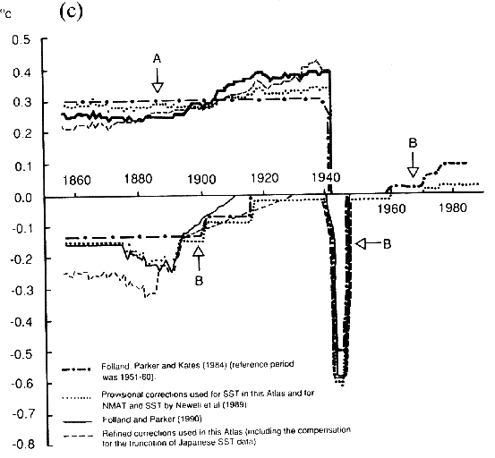 Bottomley et al. – IPCC – Click the pic to view at source[/caption]
[caption id="" align="alignnone" width="850"]
And here are the deck elevation corrections:
I am struck by the sheer number of assumptions that were made to “correct” the Sea Surface Temperature record.
The statement above was made in relation to surface energy flux fields, but it seems applicable to entire field of bucketology.
I don’t remember ever seeing glass thermometers marked with tenths unless the thermometers were specially calibrated for reading within a narrow range of degrees. Were the thermometers provided by the met office calibrated for reading a very narrow range, much like thermometers used for humans?
Greg: Coincidental alignment of averaged data from widely disparate sources scares me, especially when the alignment is to a completely different set of physically sourced data! The first question I always stutter is how and why? What is the mechanism that can take randomly collected temperature datums across wide oceans, but in very narrow sea lanes in all weather conditions and seasons and somehow the averages correlate? Those kind of graphs make me wonder just how one ship’s worth of data, un-averaged, aligns… Begin with the meta-data, sole point data and look for the correlations. Just saying, it’s the anal data miner in me.
One other comment about bucket samples. I occasionally use a bucket on my boat to wash the deck, and it is pretty difficult to get a full bucket of seawater on the deck of a boat, only about 5 ft above the surface of a calm sea, at ~4-5 kts. The bucket has a tendency to float on the surface unless it lands just right, so you have to tow it a bit till it takes a “bite” Once it does, it is effectively anchored in the sea while the boat/ship keeps moving, so you quickly run out of line, and have to snatch it up on deck. It is heavy, and if the boat/ship is moving quickly, it can be a bit dangerous to pluck it out of the sea. It NEVER really sinks below the surface – there is not enough time for that and the bucket materials are not dense, whether they are wood, canvas, or plastic.
I cannot conceive on anyone, military or commercial, using this technique from the deck of a modern ship, which has a freeboard MUCH greater than a small boat, when the engineers have SW temperatures available to them down below, inside the ship. When sailing ships were plying the oceans before the end of the 19th century they might have used this tecnique, but it would have been done when the ships were moving slowly, not at 14 kts (4 m/s). Those who suggest that you can pluck a bucket of water from the sea while 10m above the surface doing 14 kts are just plain nuts and have never actually tried it.
The sailing ships used to use a line to measure speed by throwing a small line with a piece of wood on the end overboard, and timing how far it ran out during a specified time. They really needed this information in order to calculate their position by dead reckoning, in the days before GPS and LORAN. SST would not really have been that important. When you cross the Gulf Stream, it is REALLY visible. I have done it on navy ships, as an engineer and deck officer, and on a sailboat, and you know RIGHT AWAY when you enter the Stream. The engineers see the injection temperature jump quite a bit, while the people on deck see the sea surface go from green to deep blue, and the humidity jumps. You don’t have to have a thermometer to detect it.
I believe that ALL of the temperatures on ships driven by machinery, from about 1860 to the present, are injection temperatures (from SW supply to the engines), not from buckets. Powered ships have always moved too fast to take bucket samples, and the availability of engine intake temperatures makes the use of buckets silly. So, this “methodology” for corrections rates a major FAIL from me.
The one temperature data from ships that I would be tempted to trust would be from the submarines, because they have a very strong interest in this sort of data, and the capability to get some really detailed values. And the data of interest would not be in the deck logs for the submarines, but in the sonar logs, which are not likely to be publicly available…
“For 1905-40 …. we have used a ship speed of 7ms-1. ”
It seems they don’t know much about nautical history. 7 ms-1 is equal to 13.6 knots which is certainly much too high as an average for the 1905-40 period. During WWII convoys were divided into “slow” and “fast”. The speeds required were 7 and 9.5 knots respectively. Ships that could make 15 knots or more (almost exclusively large passenger liners) were allowed to sail independently since U-boats (max surface speed c. 17 knots) were very unlikely to be able to get into a firing position for such fast-moving targets.
Incidentally this opens a simple way to check if there is a “convoy effect” in the WWII temperature anomaly. Temperatures taken by large passenger liners should be unaffected by it.
Greg Goodman says:
greg, in the merchant navy, for vessels in the voluntary observing fleet, it was the officer of the watch duty to take all measurements and update the ships log and every 6 hours write a METEO report (20 or so code groups) that I would send by morse code to shore stations.
The OOW would use a rubber bucket like this one: http://badc.nerc.ac.uk/data/gosta/figures/fig7.gif
from the bridge wing, irrespective of the distance to the sea surface. On the British ships I sailed on, it was always conscientiously carried out.
If it is your job to do it, and it is not arduous, you just get on with it.
Of course errors will creep in such as were the bucket is kept prior to being used, that should just increase error bars.
I do not know if the thermometer used was a short range one with the ability to be read to 0.1, I shall have to ask when back at work tomorrow.
When people started to use engine room sea water main inlet temperatures, I suspect initially that just a simple liquid in glass thermometer such as these:
http://www.tradekorea.com/sell-leads-detail/S00034031/V%20shaped%20industrial%20glass%20thermometer.html
They do not need to be accurate for ship board use, you are only recording a fact, nothing we can control in the engine room.
I will try to find out approximately what year(s) PT100s were introduced for this particular measurement.
Steve Richards says:
May 27, 2013 at 3:22 am
Steve is (as I recall) correct. I’m another ex British Merchant Navy Radio Officer who sailed on many OBS ships. Most ships officers/cadets carried out their 6 hourly OBS measurements conscientiously. Personally if I found a deck officer/cadet “fudging” the OBS there would be an almighty row ! Nor was I worried about complaining to the old man (Captain), if necessary. Basically if I have to send OBS every 6 hours (starting at 00:00 gmt) then the data was damn well going to be quality data !
ALL the equipment used for OBS was supplied by the Met Office, and occasionally would be checked by the local Port State Met service. Almost all (British ) OBS ships took their “voluntary” duties seriously – after all, your OBS helped generate the all important Weather Forecasts !
How good was the bucket temperature measurement ? On the ships I did OBS on ( large & small tankers, general cargo tramps & container vessels) between 1974 & 1987, pretty good ! Subject to the crudeness of the method. The detailed method is mentioned above.
Also noted above is the step change between currents etc. apart from the Gulf Stream there is also the Amazon River 200 odd (nautical ) miles off shore, the Indian Ocean/S Atlantic around Cape Agulhas, the entrance to the Baltic, currents at the entrance to the Med, etc etc .
I also remember spending 3 days doing 3 hourly OBS while we played “tag” with a hurricane in the Caribean.
There were some very dedicated people doing OBS
atheok says:
May 26, 2013 at 8:01 pm
“Auto says: May 26, 2013 at 11:50 am
… Read the temperature to the nearest tenth of a degree centigrade…”
I don’t remember ever seeing glass thermometers marked with tenths unless the thermometers were specially calibrated for reading within a narrow range of degrees. Were the thermometers provided by the met office calibrated for reading a very narrow range, much like thermometers used for humans?
Met Office thermometers that I used were graduated every 0.5 degree. Estimation was required. We managed to cope [and I dare say a ‘true ‘.24’ occasionally was recorded as ‘0.3’, and ‘.26’ as ‘.2’. I will lose no sleep over that.]
Auto
rxc says:
May 26, 2013 at 11:41 pm
One other comment about bucket samples. I occasionally use a bucket on my boat to wash the deck, and it is pretty difficult to get a full bucket of seawater on the deck of a boat, only about 5 ft above the surface of a calm sea, at ~4-5 kts. The bucket has a tendency to float on the surface unless it lands just right, so you have to tow it a bit till it takes a “bite” Once it does, it is effectively anchored in the sea while the boat/ship keeps moving, so you quickly run out of line, and have to snatch it up on deck. It is heavy, and if the boat/ship is moving quickly, it can be a bit dangerous to pluck it out of the sea. It NEVER really sinks below the surface – there is not enough time for that and the bucket materials are not dense, whether they are wood, canvas, or plastic.
I cannot conceive on anyone, military or commercial, using this technique from the deck of a modern ship, which has a freeboard MUCH greater than a small boat, when the engineers have SW temperatures available to them down below, inside the ship. When sailing ships were plying the oceans before the end of the 19th century they might have used this technique, but it would have been done when the ships were moving slowly, not at 14 kts (4 m/s). Those who suggest that you can pluck a bucket of water from the sea while 10m above the surface doing 14 kts are just plain nuts and have never actually tried it.
==
====
==
rxc – the deck wash bucket you refer to will be difficult get back aboard.
We’re not plain nuts, though, even if we’re seamen – Met Office ‘buckets’ were, and I guess still are, designed to get a small sample – outside diameter about 10 cm [4 inches], and length about 35 cm [14 inches], so did not need extraordinary strength to lift clear of the water.
My sampling was done at speeds between 8 or 9 knots and, perhaps, 16 knots, maximum, with freeboards from the lowest deck of between three metres [a small product tanker fully loaded] and perhaps nearly twenty metres [a VLCC -‘supertanker’ in ballast and flying light].
Auto
[BLAH, BLAH, BLAH warning — for real discussion, GO TO NEXT POST (at least)]
Dear WUWT Scholars and Commenters Above,
What a marvelously worthwhile discussion! The great depth and breadth of the knowledge shared along with the respectful collegiality you showed each other make this one of the finest threads WUWT will ever log.
The banter boiled down to two main themes, really, the painstakingly detailed detective work I’ll call “basic science” and the bigger picture, pragmatic, conclusions of what I’ll call “applied science”. Both, of course, are valuable. The basic science guys were stellar in their examination of all the relevant evidentiary issues and made excellent sense. The big picture men (I didn’t see even one female post), however, won the day as far as what to take away from this discussion that will help us defeat the Cult of AGW.
It reminded me of the height chart still carefully penciled and penned on the wall near the refrigerator in my parents’ house. I have younger brothers. For years, I was always the tallest. Then, as the record clearly shows, first one, then the other brother passed me by (and by a long ways!). Oh, sure, along the way, we argued, especially my two brothers who were closer in age to each other. Whether one was standing with one’s chin too high or what time of day it was or the thickness of the marker, etc…, were firmly and enthusiastically discussed. As the years went by, though, there was a trend. Whether the interim heights were accurate really didn’t matter to an applied science teenager who was now the tallest — ha!
To a basic science medical researcher, the fine details might prove interesting as he or she linked our relative growth rates to all sorts of interesting variables — and this data might one day lead to a discovery that could greatly improve the quality of life for humanity — definitely worthwhile. But, not to a teenager who just wanted to know that he was FINALLY taller than his older sister. (I didn’t yield easily — I stood on a stool and put a few fictitious data points high on the wall to show that I was far and away the tallest by leaps and bounds; but, my brother was a better data-adjuster than I and placed his last mark by standing on his tiptoes, right up against the ceiling. Hmm, any future anthropologists would come to some very incorrect conclusions about us based on that “data.”)
AGW likes to pretend that by using fantastically fine or numerous measurements they are coming closer to the truth. They are not. They are just delaying the inevitable with their smokescreen of minutiae. While meeting them on their own turf, proving, here, that the bucket adjustments are inaccurate (by tenths of a degree — but it adds up! — and I must add that for BASIC SCIENCE this is truly valuable, useful information, nevertheless…..), is a good thing, it is not the best thing for winning the disgusting-but-necessary political battle. Just as proving CO2 sensitivity is, say, only 1.7 instead of 2 or 3 is useful and good, it is not the best argument to the average person which is: THERE IS NO EVIDENCE THAT HUMAN (or any, really) CO2 CAUSES ANY SIGNIFICANT CHANGE IN CLIMATE. NONE. NO MEANINGFUL CAUSATION HAS EVER BEEN PROVEN.
So, too, here, the general trend of warming or cooling (for, all the positive and negative effects of differing places and people and instruments and methods would cancel each other out so that the general trend would be accurate), is all that matters for the older data.
The basic science work above is not fanciful and useless speculation like pondering the number of angels who could fit in a VW, it is adding truth to the picture, tiny brush strokes with a tiny brush. The big picture, what the temperature trend is, is clear (as Darrin said, “Are getting into warmer or cooler water.” (paraph)). THE BIG PICTURE WILL WIN THE WAR for truth in the political arena.
… so you’ll see this next as you scroll past the above to the next post, I’ll say it in bold and caps,
THANK YOU, ALL OF YOU, FOR THE EXCELLENT DISCUSSION ABOVE!
“Folland et al. (1984) applied corrections to NMAT to compensate for the historical increases of the average height of ship’s decks. These rose from about 6 m before 1890 to 15 m by the 1930s and 17 m by the 1980s. The corrections, based on surface layer similarity theory, removed a spurious cooling of about 0.2 °C between the late nineteenth century and 1980.
…
Folland and Parker (1990; 1991) of the UK Meteorological Office, how- ever, have developed a method for correcting the canvas bucket measurements based on physical principles related to the causes of the cooling. The cooling depends on the prevailing meteorological conditions, and so varies according to the time of year and location. Although the cooling is therefore a day-to-day phenomenon, the various influences are basically linear, so cooling amounts can be calculated on a monthly basis. The main free parameter is the elapsed time between sampling and reading. This is generally unknown and must be estimated from the data.
Why not just do some measurements?? Why talk about modelling only? Does the UK Met Office budget not extend to a couple of buckets (canvas, wood) and a thermometer? If you get your hand wet in some real measurements you will find that water has quite a high heat capacity, it takes quite a lot of heat to change its temperature. So this idea that a bucket of sea water will start rapidly cooling as soon as it is hauled up on deck is suspect, it looks like wishful thinking. What about heating of the bucket by sunlight? Why not just do an experiment and MEASURE it?? There is no need for all this freaky modelling.
Here’s what IPCC AR1 – Section 7.4.1.2 has to say on the subject:
http://www.ipcc.ch/ipccreports/far/wg_I/ipcc_far_wg_I_full_report.pdf