By Joseph D’Aleo, CCM, AMS Fellow

Tornado season kicks off in February most years, and yesterday’s storm had tornadoes, and other severe weather and with heavy rains after a snowy winter, major flooding. The tornado seasons tend to be more severe in La Ninas with larger outbreaks and stronger tornadoes.
Tornadoes tend to focus in the central and southern plains and the Gulf Coast during El Nino years, with a shift to the Midwest, the Ohio and Tennessee Valleys, and the mid-Atlantic region during La Nina years.
Bove (1999) showed El Ninos tend to produce more tornadoes in the southern plains, while La Nina seasons are more active in the Ohio Valley and the south.
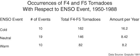
The strengths of these cycles also seem to be a factor in this data as well. Tornadoes during a La Nina are stronger and remain on the ground longer than those observed during an El Nino. That means an increased danger of large destructive and deadly tornadoes during the cold phase. There is also an increased risk of “tornado swarms” or outbreaks of 40 or more twisters from a single weather system in a La Nina season.
We believe a recent climate shift favoring a cooler Pacific and more frequent La Nina events suggests we have entered a period of increasing severe storms that could last a decade or more.
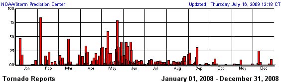
We saw a burst of activity in the La Nina year of 2008 with 1692 tornadoes.


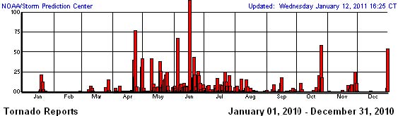
In 2010, an El Nino year, by comparison, 1277 tornadoes occurred.


SUPEROUTBREAKS
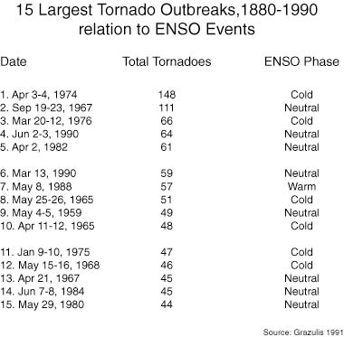
Bove found also most large outbreaks and major tornadoes occur in cold (La Nina) or neutral (La Nada) years. He refers to the analyses by Grazulis in 1991.


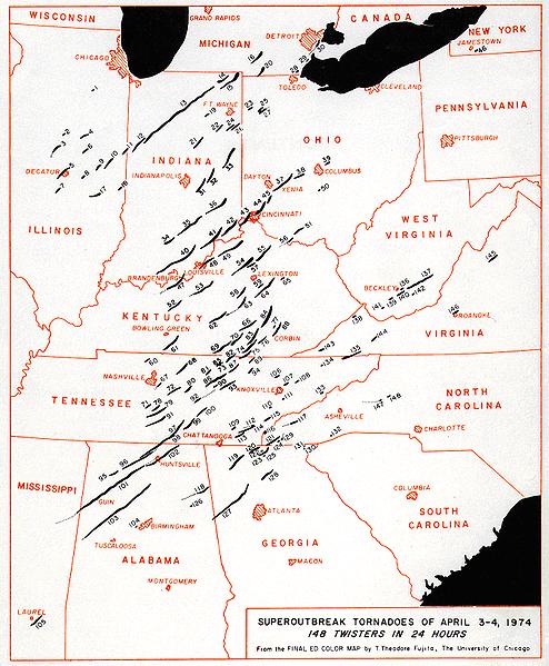
The Super Outbreak of April 3-4, 1974 spawned 148 confirmed tornadoes across eastern North America and resulted in the second highest death toll (319) in the United States. Not only did it produce an exceptional number of tornadoes, but it was also an inordinately intense outbreak producing dozens of large, long-track tornadoes, including 7 F5 and 23 F4 tornadoes. More significant tornadoes occurred within 24 hours than any other week in the tornado record.

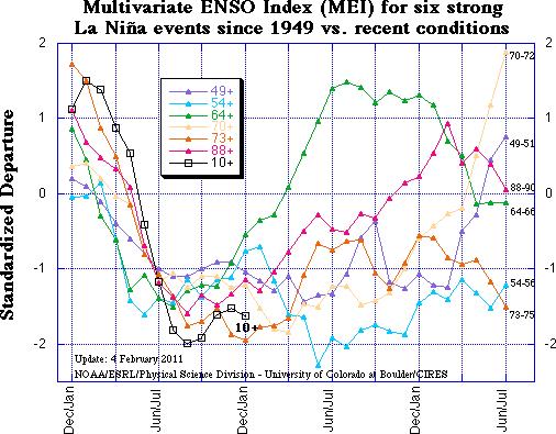
Note 1974 a major La Nina like this year saw major flooding in Australia’s Queensland and in Brazil just like this year. Note how this La Nina using Wolter’s Multivariate ENSO Index (MEI) is among the strongest ever.

Flooding
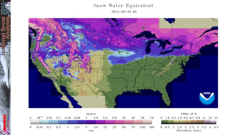
The heavy to near record snowfall season across the north has left a deep snowcover that with more spring snows and then rain is likely to lead to flooding as we saw in recent La Nina springs of 2008 and 2009. See where there is as much as 6 -10 inches of water in the snowpack as of March 1, 2011.

PDF here.
This is this mornings river flooding situation – orange, red and purple are gauges in flood.

More active in the Ohio Valley? Crap on a cracker. I’ll let you know.
Tornados and spring floods are “negative climate events”, and therefore MUST be caused by global warming.
Quod erat demonstratum.
The funny thing is that the UK turns out to be the tornado alley of Europe, of course ours are tiny compared to yours.
When I was young fifty years ago there was much debate as to whether cyclonic storms, as they were termed then, actually existed in the UK. There had been and were well reported incidents of localised damage. rooves ripped off and such like every so often but seldom any serious injuries let alone deaths. And the records went back for hundreds of years.
Modern technology, not least the video camera, has demonstrated that they do indeed exist and are very common but so minor and short lived they seldom cause much damage.
Amazing is it not how modern methods allow us to observe events about which we could only speculate about before? And equally the fact that we could not observe it until recently does not mean it did not happen. It did.
Something for the AGW alarmists with their ‘never been known to happen before’ statements to remember. Not that they will.
Kindest Regards
aunty em, it’s a twister!!! (apologies to Airplane)
You have to say a jones that I am glad I live in the UK. I know the people from the wrong side of the pond :p think theirs is the best country in the world, but quite frankly I am happy not to have tornadoes, huge earthquakes, fires, volcanoes, hurricanes and if that wasn’t bad enough everyone carrying a concealed gun, especially the mentally unwell 😀
Said in jest of course, off to make a nice cup of tea and complain about the rain.
Andy
‘Tornado season kicks off in February most years’
Is Tornado Season late this year?
The snowpack map seem right. The CoCoRaHS folks drool over snowpack measurements (and anything else that might affect flood risk). Assuming yesterday’s 0.7″ of sleet and other crud didn’t drain through the snowpack, I should have 7.5″ (19 cm) waiting to melt in the next five weeks. I had more in 2008 (8.2″) but that all melted without any fuss, much to many people’s relief.
One thing that’s worth remembering in any discussions – last February in the US saw no tornadoes. If global climate disruption will be bringing bigger and better storms, let everyone know that in the supposed “hottest year on record” they didn’t start early.
It is important to know that tornadoes were non-existent before the advent of fissile fuels.
Oh – link to the no tornados in Feb 2010 story, see
http://wattsupwiththat.com/2010/03/01/a-tornado-free-february-first-time-ever/
The correlation between La Niña and more intense weathers systems such as heavy rains and tornadoes is well know to anyone who looks. It is as predictable as harsher then normal winters in Calgary. Given the forewarning one would think societies such as ours would be adequately prepared. Instead of deluding ourselves about AGW we should be focusing our attention on adequate preparedness.
Better gliding then.
Excellent analysis in that it is news people can use. Might be interesting to see if there is a higher incidence of tornado chasers this year as I can’t imagine the warmanistas passing up an opportunity to tell us all we told you so.
We need to get out the message that this will be as a result of a cooling event, not warming.
Pat~ Fissile fuels? So tornados never occurred before nuclear power? 😉
Last year it was warmer than normal over the northeast and colder than normal over the southeast. Less of a clash between the warm and cold.
This year there is no sign of spring over shivering New Hampshire, and news of warmth and the dogwood blooming down in Georgia. More of a clash between the warm and cold.
Last spring was one of the nicest I ever remember, in New Hampshire. Mild, sunny, and with little of the dreaded “mud season.”
This spring, if it ever comes to New Hampshire, will likely be “worse than we thought.” The soil is frozen two feet down, under a snowpack which is mostly sleet and “corn-snow,” (snow melted and refrozen, so it is the consistancy of crushed ice.) There’s about a half-foot of water in the snowpack, and when it melts it can’t be sponged up by the earth, for the earth is frozen like rock. Even when the top foot of the earth eventually is thawed there still will be an impervious layer of ice below it. The result is that the top foot of earth turns into a quagmire: The dreaded “mud season.”
At least a tornado is over and done with quickly. “Mud season” drags on and on until the expressions you see on the street are of people who look ready to scream.
Here’s a good link from the USACE (where I use to work, retired now), rivergages.com;
http://www2.mvr.usace.army.mil/WaterControl/new/layout.cfm
You can download historical time series data, time to dust off that old Excel spreadsheet I have from a few years ago, if we get into the high 40’s/low 50’s, river gage wise.
I live in Vicksburg, MS and drive the levees (in LA) and drop down to LeTourneau to watch the river road turned into a broad crested weir (and kind of fun to walk into) if the river is extremely high.
Joseph,
Interesting correlation with wetland where moisture can be picked up with tornado. A great deal of evaporation in saturated land where the low land areas spawn these destructive beasts. A great deal of wind energy movement in the atmosphere starts these from the lower cloud cover down to the planet surface.
The La Nina is leaving its mark.
Besides the global temperature continuing to fall:
http://www.coaps.fsu.edu/~maue/jra25/global_temperature_anomalies.jpg
The standard precipitation patterns expected are also occuring including extra rain in Indonesia , the northern Indian Ocean, Australia, the east coast of South America and the Amazon, the west coast of Africa and the northwest of the North America (snow in this case).
Some areas in Indonesia have had over 160 inches of rain over the past year – think of 1/2 inch of rain every day.
Temperatures have been way below normal across much of North America and especially northwest North America over the past 60 days. Much more snow than normal and no snow melt so far means there will be extreme flooding in many areas, especially if Joe’s forecast of more spring rains also holds.
The La Nina climate impact maps have been bang on.
http://www.cpc.ncep.noaa.gov/products/analysis_monitoring/impacts/cold.gif
http://portal.iri.columbia.edu/Production/Home/assets/imgs/LaNinagraphic_IRI.pdf
http://www.esrl.noaa.gov/psd/map/images/olr/olr.anom.90day.gif
Otter says:
March 2, 2011 at 2:00 am
> Pat~ Fissile fuels? So tornados never occurred before nuclear power? 😉
The first known fission reactor on Earth ran a billion years ago. There were probably tornadoes before then, but there were probably reactors too. This was back when you (or nature) didn’t have to enrich uranium.
http://geology.about.com/od/geophysics/a/aaoklo.htm
http://nuclearplanet.com/Oklo.html
Joseph,
The density of the tornado is it’s destructive power.
Funny how they rotate differently in the different hemispheres due to the planets rotation and circulation.
A hurricane or cyclone will NOT cross the equator due to this as well.
“Bove (1999) showed El Ninos tend to produce more tornadoes in the southern plains, while La Nina seasons are more active in the Ohio Valley and the south.”
I wasn’t aware of that! Cool. Learnt sumtin new taday.
Lots of snow means floods if the spring temps swing up reasonably quickly -especially where the mouth of the rivers are frozen up in Canada – the Red River of the North is a classic example. However, the cold seems to be hanging on. If we sneak into spring and get a break from spring rains the flooding may not be as bad as feared from the snow pack.
I don’t know of any studies off-hand, but it’s been my observation that tornadoes here on the Southern Plains usually build up during the afternoon and early evening, while most people are awake and there’s still enought daylight to see them coming.
East of the Mississippi they seem to happen well after dark. Much more dangerous I would think, if true.
OK S.
Declines in global temps also bode ill for the Dutch. To paraphrase something I once heard about foxholes, there are no atheists when the dykes break either. North Atlantic Cat X Storms tend to make life miserable for everyone.
Alarmists will use a more active season to promote their CAGW beliefs, regardless the known La Nina link.
Sandy says:
March 1, 2011 at 11:53 pm
Not the kind of thermal I’d care to ride thank you very much!
DaveE.
Tornado production is a result of Lunar declinational tides pulling air masses from more equatorial areas into the mid-latitudes, so the peak production times when they form can be predicted as the periods from Maximum North culmination to three days after, a couple of days when the moon crosses the equator headed North, and as the moon reaches maximum South declination and several days after.
These effects are due to the production of the primary and secondary tidal bulges in the atmosphere, that arrive at the same time as the ion content of the air masses reaches a local maximum. Between the induced charge differential between the +ion concentrations riding on the more equatorial sourced air mass, established ahead of the dry line front of -ion concentrated more polar air mass, that sweeps in from the West, forcing the precipitation into the rapidly moving narrow band of severe weather from which the tornadoes form on the trailing edges.
The periods when these effects will be most likely to occur this spring,
2-25/28 for three days, which we just had, around max South.
3-5/7 slight chance of small outbreak
3-12/17 starting in Arkansas through Kentucky and the Ohio river valley
3-25/30 Starting Texas/Oklahoma/Arkansas through Ohio river valley the beginning of a long period of very wet activity most of April.
4-5/8 start up of activity
with the re-enactment of the 1974 outbreak most possible in the period
4-8/13 Maps of the expected precipitation can be found on my site, bearing in mind that the tornado and severe activity usually forms in the fast moving part of the frontal and not usually in the areas of heaviest total daily precipitation.
On the maps show on my site you can expect to see the tornado development in the areas with the “netted” looking precipitation patterns due to the usual nature of the part of the front where they occur.
1974 is one of the analog years for my forecast method, which is why I mention we may see a replay of that out break. It is also why I am in Mesa Az., instead of Kansas this spring.
Sounds like Richard Holle had some of the brown acid.
Wow, that is one of the more convoluted [trimmed] tornado theories I’ve heard in a while, especially considering we’ve had a pretty decent theoretical understanding of supercell formation for about 20 years now that doesn’t involve any of what you’re claiming. Please provide some evidence of your [trimmed] theory other than some unverifiable nonsense.
And why are the ion concentrations reaching a local maximum and minimum’s? Ion concentrations can change extraordinarily rapidly and vary on very small scales, especially with the influence of anthropogenic aerosols….just read Hans Israel’s seminal work.
[Watch the language used in public please…. Robt]
Jerky says:
March 2, 2011 at 6:25 pm
Sounds like a troll, do you have, or know of another forecast for tornado outbreaks, that you or others you work with, have formulated for the next two months?