This is a map and photo of Sharp’s Island and its sinking lighthouse in Chesapeake Bay, we’ll get back to that after the main article about Norfolk.

GreenHell Blog writes: In an above-the-fold, front-page story, the Times’ Leslie Kaufman tried to tell a sad tale about global warming-induced sea-level rise wreaking havoc in Norfolk, VA.
If the moon is going to be full the night before Hazel Peck needs her car, for example, she parks it on a parallel block, away from the river. The next morning, she walks through a neighbor’s backyard to avoid the two-to-three-foot-deep puddle that routinely accumulates on her street after high tides.
For Ms. Peck and her neighbors, it is the only way to live with the encroaching sea.
As sea levels rise, tidal flooding is increasingly disrupting life here and all along the East Coast, a development many climate scientists link to global warming.
And of course, what tale of global warming would be complete without an “expert”?
Many Norfolk residents hope their problems will serve as a warning.
“We are the front lines of climate change,” said Jim Schultz, a science and technology writer who lives on Richmond Crescent near Ms. Peck. “No one who has a house here is a skeptic.”
As sea levels rise, tidal flooding is increasingly disrupting life here and all along the East Coast, a development many climate scientists link to global warming.
The article continues, bold emphasis mine
But Norfolk is worse off. Situated just west of the mouth of Chesapeake Bay, it is bordered on three sides by water, including several rivers, like the Lafayette, that are actually long tidal streams that feed into the bay and eventually the ocean.
Like many other cities, Norfolk was built on filled-in marsh. Now that fill is settling and compacting. In addition, the city is in an area where significant natural sinking of land is occurring. The result is that Norfolk has experienced the highest relative increase in sea level on the East Coast — 14.5 inches since 1930, according to readings by the Sewells Point naval station here.
But, that is just part of the story. While Norfolk has fill subsidence issues, other areas of Chesapeake Bay have disappearing islands.
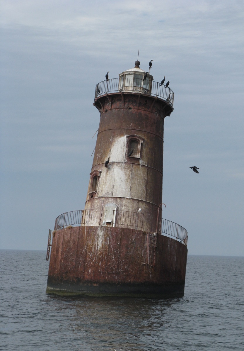
Take for example Sharp’s Island, well up into Chesapeake Bay, and now a historical footnote on Google Earth at 38.621218° -76.363095°:

Here is the Sharps Island Light in 2009, no land is visible at all now:
It has been assumed that it is a victim of “global warming induced sea level rise” also. For example from the book: Slow Motion: The Log of a Chesapeake Bay Skipjack By M. Kei:
Sharp’s Island Light was nudged into a lean by a heavy blow in 1970 and has remained that way ever since.
…
It is one of several vanishing islands in the Chesapeake, a natural process that has been going on for millennia, but which is getting worse with global warming.
But, have a look at this before and after map of Sharp’s Island, from a NOAA/University of Maryland Newsletter in 1990:

And, note the dates of the map comparison, 1848-1942. This is well before our “hottest decade ever”.
This undated historical photograph, shows there wasn’t much left when it was taken, perhaps at high tide:

While “climate change” gets some blame in the article:
Over this last century, once inhabited Chesapeake Bay shorelines have been disappearing rapidly, transformed by rising waters into shoals and marshes. The loss of land, says Michael Kearney, a geographer at the University of Maryland College Park, has been accelerating much faster than sea level rise from global warming can account for.
He and Court Stevenson of the University’s Horn Point Environmental Laboratories believe that accelerated sea level rise is the result of massive upland and shore erosion and depletion of underground waters.
Though it has been generally accepted that water levels have risen steadily since the 1800s, Kearney and Stevenson believe the rates have increased more rapidly along the Eastern Shore since the mid-19th century. From core dating and tide gauge records which date back to the early 1800s in Baltimore, there is evidence of acceleration in rising waters,” Stevenson says. “The problem is that we could not trust existing data.”
He found a way to get more accurate data, and this is what he found, bold emphasis mine:
He found that the rate of change in land area loss during the 1600s and 1700s was fairly low, possibly because sea level rise is slow. “That overlaps the marsh record,” Kearney says, and “it is what we would expect given the several hundred year cooling between 1450 and 1850, known as the Little Ice Age.”
Between 1850 and 1900, however, he found a dramatic increase in land area lost to marsh or erosion: Sharps island near the Choptank River, for instance, lost more than 80% of its remaining area, Poplar Island 38%, James Island 50%.
Then, between 1900 and 1950, another decline in land area occurred. “it must have been eroding very quickly and unexpectedly,” Kearney says. “People were building on a lot of these islands – then all of a sudden they had to move off.”

[Oh no, “Climate refugees” ! Maybe the U.N. IPCC can scare up some reparations money to families /sarc]
“When I saw that island data,” says Stevenson, “that’s when I really got excited: we knew we were seeing accelerated sea level rise in the tide gauge record, but this shoreline data just reinforced that belief.”
Worldwide estimates of sea level rise due to climatic warming range between 1.2 and 2.4 millimeters per year. “The increases in sea level rise we are seeing in the Bay are some 3.4 millimeters a year,” Stevenson says. “There have to be other things going on – global warming alone cannot account for it.” Both he and Kearney believe those other things are land erosion and subsidence, or sinking, due to underground water withdrawal.
The sediment load Chesapeake Bay receives, the result of land clearance and development, is massive – some 2 million metric tons a year. Under this weight, Kearney and Stevenson argue, the Bay crust is sinking, literally “downwarping” the bottom and displacing upper mantle material. At the same time, they hypothesize, groundwater withdrawal from surficial aquifers has been increasing for more than a hundred years.
Of course these are hypotheses, Kearney says. “We haven’t shown that groundwater withdrawal is the problem, but it is curious,” he adds, “that the timing of initial canning operations on the Eastern Shore in the 19th century corresponds to the rapid acceleration in shore erosion of Bay islands as well as increased rates of local marsh loss.”
Just what are the relative contributions of climatic warming, sediment loading and groundwater withdrawal to accelerating sea level rise? That is an unknown, Stevenson says, though he thinks warming is only a quarter of the problem. “But there’s not a lot of data.” The poultry industry, for instance, uses a great deal of groundwater; so do the power plants. With the prospects of increasing development throughout the Eastern Shore, the demand on underground water will continue to increase.
In 1998, the USGS had this to say about the area:
Tide gauges for the Chesapeake Bay and the Mid-Atlantic coast show rates of sea-level rise twice that of the worldwide average.
And here’ s one tide gauge that shows what was going on between 1937 and 1997:

So, it sure seems like land use change, sediment load, groundwater withdrawal, and subsidence, are all factors in the area. Sea level rise is surely a contributor, but only one of many factors. Kudos to whoever the NYT editor was that added the part about subsidence in Norfolk.
How can they call sinking land, sea level rise?
@ latitude says:
November 26, 2010 at 1:35 pm
How can they call sinking land, sea level rise? They don’t want to get tangled up discussions of relativity. It would get them off message.
Sounds more like land levels sinking than sea levels rising.
Here’s the latest tide gauge data for Solomons Island MD.
http://tidesandcurrents.noaa.gov/sltrends/sltrends_station.shtml?stnid=8577330
It is useful to click around that tide page. Very little evidence whatsover for accelerating sea level rise.
Looks like the region may be a smidgen higher than the worldwide sea level rise average of 3.0 mm/year, but all pretty much within that range with the errors taken into account.
My old Rand McNalley globe shows the world’s oceans to be connected. Do new globes show where the oceans have been partitioned off into sections so some can rise while others stay the same? Has the moon’s gravitational pull changed so that it now selectively affects tides?
Maybe it’s a combination of both.
This article from the Daily Telegraph , dated 7th October 2009 might be pertinent to any further discussion on this topic.
http://www.telegraph.co.uk/earth/earthnews/6226537/England-is-sinking-while-Scotland-rises-above-sea-levels-according-to-new-study.html
My little unimproved lot, almost at the end of Broad Marsh Lane, Hayes VA, will have a dock: my great-grand-xgrand children can drive pilings for a dock and pay taxes with moorage fees. Better that than scavenging wind-fall lumber for heat, when the glaciers advance.
For now, San Jose, Costa Rica, about 3000 feet elevation, offers other concerns: earthquakes, volcanoes, land slides, bridge collapses, and dengue fever.
Think I´ll stay awhile. UNFCCC Executive Secretary Figueres has plans for her hometown and its needed infrastructure: of the oldest democracy on the Isthmus gets at the head of the welfare line, the UN can channel expropriations from industrialized to developing nations. Approval of Nationally Appropriate Mitigation Actions {NAMA}, will provide mass transportation and waste treatment facilities, for example. Keep an eye on Cancun for the latest.
Thanks, all, especially our host, for continued good work.
What I find sad about the global warming movement is the mindset that if the facts don’t add up, omit or change the facts until they tell the desired story. The continued and increasingly frenzied skewing of reality by the “believers” underscores how desperate they have become to shield themselves from the growing refutation of their doomsday prophesies.
Has anyone accurately measured the ocean bottom to see if maybe it is rising every year? Does the sediment dumped into the oceans by rivers and erosion of shorelines contribute significantly to sea level rise? Is it possible that the continents are settling down instead of more water rising up?
I wonder if Sharpe Island was Michener’s inspiration for “Devon” Island in Chesapeake.
Seems they’ve been worried about erosion in Chesapeake Bay for a long time.
It’s almost like the entire bay is a collapsed river valley.
Archaeologists learned in the 19th century that the James River (which flows into the Chesapeake) has been rising a little over a foot per century since 1607 when colonists arrived in Jamestown, so this is news only to alarmist journalists. English colonists began settling the Norfolk area shortly after Jamestown, so a lot of the roads, especially adjacent to the water, were laid out over 400 years ago. I don’t think we should be surprised that things have changed a bit in four centuries.
I believe that I could qualify as a ‘science and technology writer’ who actually understands the difference between relative and absolute sea level.
And I would submit that Jim Schultz and his neighbors on the Richmond Crescent are experiencing changes in land use and normal coastal processes.
So essentially the dumba frakking hippies want to be one of them global warming super local phenomenon right? Because the ocean where I live has become so much less these last few years so maybe it went to drown out a puny island somewhere else for some local people in their local light house made for local people only . . .
@ Kim Moore says:
November 26, 2010 at 1:59 pm
Actually, the Earths gravitation does vary by location ( ooh! an unintentional rhyme 🙂 ) Here’s a recent gravitational map ( see sidebar ) http://www.space.com/scienceastronomy/gravity_map_030725.html
Gee, somehow most if not all of the real reasons for this case of disappearance due to “global warming-induced sea level rise,” sound amazingly like the real reasons given for how New Orleans will eventually go away due to “global warming-induced sea level rise.”
WUWT? ☺
I lived in Romancoke on Kent Island, Chesapeake Bay in the 1970s. There were no city water mains at the time and all my neighbors had their own water wells. I haven’t been back to see if that’s still the case.
This reminds me of New Orleans. Much of the city is below sea level and still falling, the only thing keeping Lake Pontchartrain from taking over the city are artificial barriers and water pumps, and thanks to all the levees on the Mississippi River the protection from hurricanes is eroding faster than ever.
Natural forces are always eroding land. Just south of Norfolk are the Outer Banks, barrier islands formed by wind and the Gulf Stream current. I visited a place called Fort Fisher. During the Civil War, Fort Fisher guarded a key port in nearby Wilmington. There remains the sand fort the Confederate army built. When they built it, it was adjacent to the ocean. Today it is several hundred feet away from the ocean.
Nature is always changing the land. Nothing we do will change that. The difference is, now those natural changes can be taken advantage of for nefarious purposes.
Reminds me of Venice, Italy. After a thousand years of the city of Venice sinking, it is now being flooded by rising sea levels.
Floods turn Venice into one big canal. http://www.theaustralian.news.com.au/story/0,25197,24743931-2703,00.html
Could part of the reason possibly be subsidence? Venice anyone? That might also help explain why a big sturdy lighthouse was pushed out of vertical by the wind.
Recently I was lucky to visit a beach where I spent many a happy childhood summer’s holidays forty years or more ago. The beach and sea are still were I left them, as was the ancient harbour, pier etc. If we are experiencing seal level rise then I’d love to see where. More likely we are seeing changes due to coastal development, often caused by industrialisation and population growth. Of course we also have some ongoing land elevation changes due to rebound etc due to the last ice age. But hey, why not blame everything on AGW? It’s easier than doing real science.
I am going to suggest this is not fraud so much as pure stupidity.
I was born & raised in Portsmouth, Virginia just across the Elizabeth River from Norfolk. Norfolk also borders the Elizabeth River. At high tides and heavy rains both Norfolk and Portsmouth have areas that have always flooded. In fact, I could sit on my front porch and see tide water coming out of the storm drains, instead of water flowing away into the drains. This was in the late 1930s & ’40s. Waterfront areas did, and still do, flood in heavy rains and high tides. I don’t think AGW /”Climate Change” or “Climate Disruption” has anything to do with it. This is just another scare tactic on the part of the alarmists.
I live in the Chesapeake watershed (which now extends all the way into western upstate New York, very nearly to the Great Lakes, thanks to drainage ditches being classified as “intermittent streams” in many comprehensive plans), and the entire eastern shore is alluvial land.
The drainage from the Susquehanna when the glaciers melted deposited it, and now it is subsiding.
Funny how so much on earth is cyclical, over millions and millions and millions and millions of years…
One key feature of sea level rise due to ‘global warming’ is that is should be uniform around the world. Global warming is *not* going to cause oceans to pile up more in one place than another. Local variation MUST be due to other causes, and the variability of ‘sea level rise’ magnitudes and rates on a local scale indicate that any ‘global’ effect is so small as to be lost in the data noise.
It is also the centre of a 90 km wide crater from a 4 km asteroid strike just 35 Mya which means it is not a stable region. It also sinking due to post-glacial rebound – about 1.5 mms per year (it was uplifted in the ice ages because the weight of the glaciers farther north suppressed the land there, pushing a bulge up at Chesapeake which is now settling).
http://en.wikipedia.org/wiki/Chesapeake_Bay_impact_crater
http://www.ngs.noaa.gov/GRD/GPS/Projects/CB/SEALEVEL/sealevel.html
@ HalfEmpty: Chesapeake Bay is a former river valley that was formed during the last ice age. Chesapeake Bay, Delaware Bay and the canyon off New York harbor were all formed from glacial outwash as sea levels were at least 300 ft lower during the ice age.
Had the marsh been left completely alone by humans it would generally rise with sea level rises and fall with sea level falls – just like coral island atolls.
Someone had better copyright that historical photo before Al or WWF use it to illustrate Europe in 2020.
Here comes Chris, Norfolk, VA, USA, aka savethesharks ?
It boggles the mind how unbearably stupid and one-sided these people are when they use the term “sea level rise”.
One mm / year for a while in the past 100 years, a slight decline, and now relative stability, according to the world’s preeminent sea level expert, Dr .Nils-Axel Mörner is hardly anything to be concerned about.
But of course it doesn’t stop the Maldives from holding a parliament meeting underwater, even though their sea levels are dropping….but I digress.
The “land level sink” is the concern. And Norfolk sits in a similar “forebulge region” from the last glaciation, as does The Netherlands and other areas around the North Sea.
All of this can be geo-engineered, just as the Dutch have been doing for 1000 years.
Also there have been recent decadal higher than normal tides for the Mid-Atlantic. A yet undiscovered cycle?
http://hamptonroads.com/2009/07/higher-tides-affecting-entire-east-coast-region
http://www.wired.com/wiredscience/2009/07/hightides/
Chris
Norfolk, VA, USA
Coos Bay Oregon has similar problems, when a stormtide hits, you can take your
jetski down Hwy 101….
It’s original name was “Marshfield” -better fit.
They’ll be OK, the good Lawd willin’ an’ the crik don’t rise.
🙂
Bill, above, has the solution: bring the glaciers back down to NY so Chesapeake can pop up above the waves again!
Speaking of Venice, sunspots are to blame:
http://www.upi.com/Science_News/2010/08/02/Sunspots-linked-to-Venice-flooding/UPI-98191280790936/
Neither the “scientists” nor I can figger out the connection.
The graph at
http://tidesandcurrents.noaa.gov/sltrends/residual.shtml?stnid=8577330&name=Solomons+Island&state=Maryland
is the Interannual Variation at Solomons Island (through which my wife and I passed on our sailboat a couple of weeks ago). While the Mean Sea Level Trend (link provided above by John M.) shows rising levels, this Interannual Variation is visually flat.
Can someone explain the differences between the two?
savethesharks says:
November 26, 2010 at 6:34 pm
“Also there have been recent decadal higher than normal tides for the Mid-Atlantic. A yet undiscovered cycle?”
This paper suggests one possibility.
http://www.agu.org/pubs/crossref/2007/2007GL030862.shtml
Copy the following address in to your browser, and observe the expansion of lower Manhattan since 1660.
http://www.racontours.com/archive/coastline_anim.php
Note that the West Side Highway (West Street) over half of the World Trade Center site, and the South Street Seaport were “under water” in 1660!
Dave Wendt says:
November 26, 2010 at 7:34 pm
This paper suggests one possibility.
http://www.agu.org/pubs/crossref/2007/2007GL030862.shtml
==============================
Thanks for that, Dave. Any idea how I would get the complete paper? I am not a subscriber unfortunately.
Looks like an interesting read.
Chris
Norfolk, VA, USA
How do they measure ‘sea level rise’? Is it like measuring the rising temperature using thermometers accurate to +/- 5 degrees (?). You can’t just put a stick in the water and measure the average of the waves…..unless you are a AGW’er of course. Or tack some proxy signals to make it look like a hockey stick. How is this done? Makes you wonder if the MSM gets anything right about anything. I suspect not.
I’ve never been quite sure how we can really tell sea level rise/fall – several examples of land subsidence have been given here, another that was occuring at least at some point was the coast around Houston & Galveston, Tx. Then you have situations like the Florida Everglades, where iirc, our water control with levee’s and canals starting causing significant amounts of land to be lost because of changes in sediment deposition or other changes that the canals etc., caused… and I believe, once we allowed some areas to return to a more ‘natural’ water flow, that ‘land’ being eaten up by the sea started reversing… its not like we’re talking about a bathtub with solid floor & walls and a certain water level….. its a misshapen ball with lower areas water covered, land rising and falling at various rates and for various reasons both under the oceans and above, glacial rebound or similar effects, or subsidence from below ground fluid level changes… add to that a hydrological cycle that puts various amounts of water in the air coming from both land and oceans… then we get uneven water spread too, from things like La Nina & El Nino…. land growing from ocean currents depositing soil, sediments, whatever, land growing from coral growth, land being eroded from ocean currents, coral’s dying off…. volcanic contributions including significant ones along sea rifts that are just now becoming discovered and appreciated, volcanism even creating new islands, or like the pre-krakatoa massive eruption, vaporizing significant amounts of islands/land leaving an ocean covered caldera…. sooooooo, then where are we for really telling what the ‘sea level’ is or isn’t, on a mm scale no less? Perhaps all of these things have too small an effect for the vast amount of water in the oceans, but conceptually this has always been a bit of a bother for me.
The first mention of Nix’s Mate, the smallest island in Boston Harbor, was 1636. It’s shrunk to 0.9 acres at low tide from it’s original 12 acres. It was used as quarry for ship’s ballast in the sixteen and seventeen hundreds (as well as a gallows for pirates). Like everything else in the Harbor, it’s also subject to the daily nine and a half foot tides. There’s no mention in anything I’ve read of sea level rise being the cause of it’s near disappearance.
When sediment load is mentioned in the article, it is associated with weighting down the bay area land. However, another factor would be the filling in of the bay causes some of the encroachment of the water onto the land. If the volume of water passing through the bay is the same, then the same cross-sectional area will have to be maintained. Makes sense that the water would create an apparent rise in the confines of the bay. Also, water removed from the ground is used, then “flushed” to the bay which increases volume, in turn increasing the required cross-sectional area. Once the volume of water is out of the bay the apparent rise in level dissipates. What is the level history of the ocean just off the mid Atlantic states as compared to the Chesapeake Bay?
savethesharks says:
November 26, 2010 at 8:22 pm
Dave Wendt says:
November 26, 2010 at 7:34 pm
I thought I’d saved the link to the PDF. Whoops! Can’t find the link to the full paper right now but this gives more info.
http://www.aviso.oceanobs.com/fileadmin/documents/OSTST/2007/miller_gyre.pdf
Is there a geostationary satellite that tracks its distance from the surface of the sea at various points within its line of sight? Would this accurately measure sea level from the center of the earth, or are there fluctuations in gravity or the earth’s rotational speed that would make such a measurement inaccurate?
Here’s the USGS definition of “sea-level change”: Variation in the relative vertical position of land and ocean waters. Caused globally by changes in the distribution of ice masses and the shape of the oceans, and locally by the rate of uplift or subsidence of the land surface. Includes both global (eustatic) and local (relative) sea-level variations. http://www.usgs.gov/science/science.php?term=1028
Nothing there about an absolute measurement of the mass of the water in the oceans.
And, as I’ve written previously, but have seemingly been ignored:
http://www.yorkshirepost.co.uk/news/Discovery-of-log-boat-shows.5537797.jp
http://www.severnestuary.net/sep/pdfs/severnarchaeodesignguidefinal06.pdf
http://www.rcahmw.gov.uk/HI/ENG/Heritage+of+Wales/Places/Sea+and+Coast/
http://www.archaeoleg.org.uk/pdf/roman/KEY%20SITES%20SE%20WALES%20ROMAN.pdf
This story only goes to highlight the problems of using one station for measuring a global phenomenon; you get errors and the wrong assumptions.
Globally sea levels have leveled off, due to cooling waters probably, so any rise in Chesapeake Bay has to be due to sinking. Rather like Bangladesh a country on a delta and the worlds largest alluvial fan, sinking is due to extra sediment increasing natural dewatering and consolidation.
Sea level is one of the most difficult things to accurately measure because of all the inputs that drive the changes.
I cannot find the links but there were reports in the UK about dredging of shipping channels and for building materials, causing coastal erosion and or sinking of shorelines. In the Bristol Channel the sandbank that is being dredged is many miles from where the beach is disappearing but the currents carry material at quite remarkable speeds and the erosion only started after the dredging started on an industrial scale.
Or maybe Gilligan has been moving the measuring stick out into deeper water to catch bigger lobsters…
savethesharks says:
November 26, 2010 at 8:22 pm
This is a later paper that covers much the same ground as Miller and Douglas and basically supports their results.
http://www.ocean-sci.net/6/185/2010/os-6-185-2010.pdf
In our high school geography classes in the 1950s we learnt about places such as Mexico City and Phoenix, Arizona, which sunk and continue to sink due to artesian bores pumping water out from under relatively recent urban settlement and development. There was no such concept as ‘global warming’ then and our science teachers seemed to be quite keen to discuss the LIA with us, how the earth had warmed since then and the probability that the earth would eventually cool again slightly as it entered another period of glaciation.
But that was before Post-Modern thinking made trendy academics forget the first principles of their various disciplines.
In the town where I grew up, the city council built a very nice public swimming pool and leisure complex fed by artesian bores. Unfortunately, the artesian water was eventually contaminated with increasing amounts of sand which had a nasty effect on the pumping equipment. The sand contamination continued to increase until an engineer suddenly realised what was happening under the comples. The pumps were switched off while investigations were carried out; the complex, it was discovered, was now sited above an enormous cavern. New bores were sunk, this time to pump sand into the cavern, and the water supply was switched to run off the town mains fed from a catchment area in the hills behind the town.
The vacuity of some so-called science writers, such as those who were the authors of the article, leads one to wonder if science education was missed entirely by them.
In the reality of hippie religion of climate change and its litany of sea level rise.
Titanic didn’t sink, it was the rapid sea level rise did it! We now exonerate the ship builders and designer once and for all. Forgive them o’ you gaia, They were the victims of the evil coal burners that pays our wages.
Isostatic depression and Isostatic rebound account for all sorts of interesting local variations. In some places the land is rebounding (rising) faster than the sea, and has been doing so ever since the end of the past ice age. Where shorelines in other parts of the World indicate the sea has risen hundreds of feet, due to the water released by melting icecaps at the end of the past ice age, in central Scandinavia and in Hudson Bay the ancient shorelines are hundreds of feet above the current shoreline, rather than hundreds of feet below the current shoreline.
http://www.homepage.montana.edu/~geol445/hyperglac/isostasy1/
Geologists who studied isostatic motions, or isostasy, were in the majority before the theory of continental drift, or plate tectonics, was accepted. Isostasy was used to explain the uplift of every mountain. Since plate tectonics was accepted, isostasy has been neglected.
In some ways this neglect was earned. Those focused on isostasy sneered far too much at those who first proposed plate tectonics as a theory, and after plate tectonics was accepted they got their sneering thrown right back in their face. The idea that isostasy could raise towering mountains was laughed at.
Now, however, it is understood that there are some mountain ranges which plate tectonics can’t explain, and isostasy can. For example, the mountains surrounding the Greenland icecap, and the mountains surrounding the melted icecap which once sat in the middle of Scandinavia.
http://folk.uio.no/yuripo/papers/medvedev_geology_2008.pdf
One lesson seems to be that sneering has no place in truly objective science. Both plate tectonics and isostasy deserve further study.
Besides an icecap pressing land down beneath it, there is an area known as the “forebulge” which rises, around an icecap. Thus, after an icecap melts, the land beneath it rises, but some lands to its south can settle. Scotland still rises, as London settles, and Hudson bay still rises, as (perhaps) the shore of Virginia settles.
Also the removal and addition of stone has the same effect as the removal and addition of ice. When a glacier or river carves away rock, the land rises where the rock is removed, (lifting the land to either side of a glacier or canyon,) and the land settles where the removed rock is deposited, (in a delta or on a continental shelf.)
One thing I’d like to see studied more is the possibility of short-term uplift and depression. Some Viking sites up in Greenland have submerged shores, as if their docks and piers sank as the glaciers came down the valleys during the Little Ice Age. Now, as the ice retreats, the sinking has ceased, and if the melting continued the shorelines might re-emerge. A response this swift, to the local advance and retreat of glaciers, is not often considered. Most people think of isostatic rebound as very slow and ponderous.
At the very least, it would make for a good Tolkien-like tale, to have isostatic rebound occur quickly, or even as an earthquake-like jolt.
Sharps Is. lighthouse did not begin to lean “due to a blow” in 1970. Sharps Is light started leaning because of ice flows in 1978. I remember sailing by the lighthouse the summer before and it was not leaning and then sailing by the light after the freeze and it was leaning. Also, Bloody Point light several miles north developed a slight lean the same winter.
That winter was extremely cold. The Bay froze well into Virginia. A couple of anecdotes from that winter:
1) An ice breaker had to be brought in to clear a path to Smith and Tangier Islands to get heating oil to the inhabitants
2) Jimmy Cantler drove his pickup truck out to Thomas point light that winter (you can see the picture on the wall of his pub).
3) I went ice skating on the Severn River in Annapolis
Finally, the picture provided by the Hanks family must have been circa 1950. The bathymetry from the NOAA charts of the area dates from 1958. It shows Sharps Island as a mud flat that appears in low tide but dissapears at high tide. 1942 maps show a larger island than is shown in the picture.
I am still not sure there has been any significant sea level rise at all, in recent centuries. The Med is a good place to look, as it has no tides to confuse the issue.
Across the Med, Greek and Roman ports can be found at or above sea level. Land rising may be an issue here, but most of these lie on a recognised subduction zone, which would have an opposite effect.
In addition, many cliffs along the Greek islands and Turkish mainland have a deep undercut at sea level (due wave action and no tides). There are no undercuts abouve the waterline, and no undercuts visible for up to 8m below the water line. This indicates that the sea level has been constant with land levels for some considerable time. If one were to invoke sea level rise, or land movement, one would have to explain sea level and land rising at exactly the same rates, which is unlikely.
The evidence in the Med seems to point towards static sea levels for many centuries.
.
>>Seems they’ve been worried about erosion in Chesapeake Bay for a long time
Is that why they dump cars in the water there, to prevent further erosion??
.
Regards the links given to UK archaeological discoveries, you have to be caureful with this because there are significant land movements in this area.
The north of Europe is rising, due to ice-age rebound, causing the many raised beaches all across Scotland. Areas near the North Sea may be sinking, or not rising so rapidly. The numerous mamoth tusks and tree stumps that litter the bed of the North Sea are a testement to this being dry land, although that may be more due to ice age sea levels being lower.
Finding a static area of land that has archaeological evidence of past sea levels in not that easy.
We lived in Norfolk from 1981 to 1993; wonderful city, fascinating topography. For a time I sold real estate. One of my listings was about 100 acres of land near Sandbridge, maybe 2 or 3 miles from the Atlantic. Its highest point (the 100 acres, I mean) was 2.5′ above sea level. The land could not be built on because it would not perc; dig down three feet and you met sea water. It had been that way since the area was settled, early 1600s. Other places were constantly shifting. Willoughby Spit, on which thousands of people now live, was created by a hurricane in the 19th century. It could be uncreated by another one. Sea level rise has little or nothing to do with it. Currents, storms, land use & construction–all of these change the land. People have had to move in the past, and I’m sure will continue to do so. Flooding–even from heavy rains–was always common. I remember a sudden rainstorm that dumped 5″ of rain in downtown Norfolk in about 2 hours; I saw a city bus floating sideways down Brambleton Avenue. There was bright sun and no rain 8 miles east, at the border of Virginia Beach. People in Hampton Roads adapt. They always have, as they must. Maybe the sea level will rise significantly; maybe not. Either way, people will adapt.
If only the world would just stay still long enough for us to measure it!
The trouble with some folk is that they have this mental picture of how the Earth should be. It tends to be mainly a static one with any variations limited by a painfully narrow mindset. It is shameful that so called scientists get caught up in this ‘political’ view of the world. It is even sadder that at these, so called, tipping points hard line extremists become even more intransigent and bellicose.Maybe we should be finding ways for them to exit gracefully, but then after all the pain, expense and misery they have put us through one does feel like it’s payback time.
Meteorites and asteroids are constantly entering the atmosphere, and much of the dust must end up in the oceans. To what extent could this filling in contribute to changes in the relative heights of the oceans and land?
When you channel a tidal valley to build/plant on the drained rich soil, the water will definitely rise if you are near the new controlled in- and out-flow channel. And with the increased water flow pressure in that channel, soil erosion will be swift. That island didn’t stand a chance. Yet it never ceases to amaze me how people will flock to the banks of a channel to build their dream home. But it’s the last place on Earth I would build unless I had a Noah complex.
A great read on dealing with river tidal flooding in the South can be found in Grant’s biography. Many pages are dedicated to examining how Grant and his Army circumnavigated tidal valleys in order to advance towards towns and cities. Diked channels were far and few between leaving shallow water and bog everywhere.
Once a tidal valley is channeled, there is no question that any amount of sinking, combined with increased soil erosion, combined with sea level rise will leave you packing your bags for drier ground. Or asking for a guv’mnt handout.
Kip Hansen says:
November 26, 2010 at 7:24 pm
The interannual variation is what’s left after the underlying long term trend and the seasonal effects have been removed. The link you provided has a discussion lower on the page.
I’ve lived along the Chesapeake all my life. Sometimes, when the wind is right, blowing up the bay, we have extremely high water at high tide. And conversely, when the wind is blowing down the bay, we have low water, even at high tide. These are natural phenomena, over which man has absolutely no control. If you want to have some fun, try navigating the shallower parts of the bay in a boat that draws some water when the wind is from the north-northwest. I am confused though. The last time I looked, the Chesapeake was connected to the Atlantic. So someone explain to me how, unless the wind is involved or the Susquehanna is really flooding, the bay’s sea level is higher than the oceans.
@899 says:
November 26, 2010 at 10:21 pm
If you want to be understood, why are you posting links to PDF’s without stating a position. I followed one of your links and still don’t know what you wanted to say. I guess you will continue to be “ignored”.
@Anthony Watts
The eastern shore of the Chesapeake bay (in many places) has earthen cliff faces that are eroding into a shallow tidal plane. So, the sediment load from rivers may not be as large as from the edges of the bay itself. On the other hand, the oyster islands built up from shells are reportedly subsiding due to a viral illness killing off the native oysters. They are now collecting shells from the local restaurants to dump back into the bay to serve as attachment points for more oysters. http://wjz.com/local/oyster.Restore.native.2.2020990.html I’m not sure how this affects the overall topography of the bay, but, it’s supposedly a major driver which isn’t being mentioned.
We have a further problem reported in some areas of the bay due to the introduction of nutria on the eastern shore. They introduced this large rodent thinking they could raise it for food & sport, but, it ended up escaping and destroying the vegetation protecting the marsh land from erosion. http://www.chesapeakebay.net/nutria.aspx?menuitem=16941 Hence, wider shallower bay.
An interesting NOAA article on sea level rise specifically mentioning Baltimore as rising more slowly due to interglacial rebound of the land: http://www.ngs.noaa.gov/GRD/GPS/Projects/CB/SEALEVEL/sealevel.html However, it’s very confusing in that it has rebound playing against sinking of the entire region.
Pamela Gray says:
November 27, 2010 at 7:55 am
Yet it never ceases to amaze me how people will flock to the banks of a channel to build their dream home. But it’s the last place on Earth I would build unless I had a Noah complex.
===============================
Ummm….what dream homes? There is a geostrategic and geopolitical reason Norfolk / Virginia Beach has grown to 1.7 MM people.
The largest natural deep water harbor in the world feeding into the busiest (for ship traffic) and one of the largest estuaries in the world, such estuary feeding the ports of some of the largest metros in the USA: DC, Baltimore, and Philly.
And unless the USA wants to lose its superpower status with the world’s mightiest, bestest [sic, lol] baddest Navy, then Norfolk ain’t going anywhere anytime soon.
Point taken though on people who build on/in sandbars or marshes.
Chris
Norfolk, VA, USA
Today’s word is “subsidence”.
Whenever you hear the word subsidence, scream real loud.
Ahhhh! Heh, heh.
And that’s the only way to measure sea level change that makes sense to me – e.g., relative to many many different locations, and I would think that they would need to be rocky locations, e.g., not beaches or areas that we know are greatly affected by erosion and deposition…. but therein lies the problem also, because then how, with all the many many confounding factors, could they possibly tease out how much is supposedly due to AGW?
This gets even stickier when one has to factor in rise based on expansion from temperature increases. This is where I suspect the circular logic is immediately injected – e.g., any ocean expansion ‘must’ be from temperature increases caused by man pumping CO2 into the atmo…. when I keep suspecting that much of the CO2 rise isn’t from us at all, but from ocean offgassing post LIA. Only I feel like I’m missing/forgetting something here – don’t they say there is some way to supposedly tell what CO2 is from ocean off gassing vs. our fossil fuel burning? Would someone fill me in on that bit or provide a link that’s a fairly quick read but scientific on this issue?
As to your satellite question Paul – they are using GRACE this way at least in part. Problem is its only been up there a decade or so I think – and they are still trying to work out just what the right math is behind the calculations necessary to result in anything meaningful. I’m not sure if its GRACE or some other satellite they use that shows how water actually gets pushed up and/or expands and is higher along the band of heated water and towards the west coast of the USA during El Nino’s…
So there are some satellites being used along the lines of your question. I’ll let you dig into it, but for a start google the GRACE satellite, see several articles here at WUWT about it, and also try: http://climate.nasa.gov/SeaLevelViewer/seaLevelViewer.cfm I’m not sure what satellite they use, just found the thing for you googling satellite el nino sea (height OR level) and I’m sure you can find more with a search along those lines… I know I’ve seen a really intriguing ‘map’ that was 3Dish, showing the sea height increase from El Nino better than the simple color change map of that sea level viewer, or at least that particular page of the sea level viewer….
re post by James Bull says: November 27, 2010 at 1:52 am
I cannot find the links but there were reports in the UK about dredging of shipping channels and for building materials, causing coastal erosion and or sinking of shorelines. –clip– and the erosion only started after the dredging started on an industrial scale.
I know in the USA there were attempts to stop beach erosion at popular beaches by building dykes or breakwaters or various edifices to try to divert or change currents that were thought to be carrying off sand…. with the result being an INCREASED erosion rather than a decrease. The best laid plans of mice and men. ;0) I was also surprised to hear that supposedly many popular beaches actually regularly have huge amounts of sand brought in to replace that lost from erosion. Who’da’thunk it? Could be urban legend… I haven’t verified it, and memory of where I heard/read it vague but I think from a reputable source.
Anyhow, only point being that as James and others here have noted, there are constant natural processes that make everything change. Some slower, some faster.
re post by Beesaman says: November 27, 2010 at 5:56 am
If only the world would just stay still long enough for us to measure it!
Its the Heisenberg Uncertainty Principle in action, macro scale. ;0)
I wasn’t aware until this expert informed me that a full moon affected the high tide more than one waxing or waning or anywhere in between.
I’m more terrified of that, the change in mass which must be responsible for the change in tides.
Morons.
>>I wasn’t aware until this expert informed me that a full moon affected
>>the high tide more than one waxing or waning or anywhere in between.
>>I’m more terrified of that, the change in mass which must be responsible
>> for the change in tides. Morons.
Sorry, Dave, are you serious?
He is right, in that the full and new moons cause higher tides than anything in between. These are spring tides, as opposed to neap tides.
The increase is due to the sun and moon being in alighnment, and thie mutual gravitational forces reinforcing one another.
.
“We are the front lines of climate change,” said Jim Schultz, a science and technology writer who lives on Richmond Crescent near Ms. Peck. “No one who has a house here is a skeptic.”
That’s probably because sceptics are too smart to buy or rent real estate that is prone to serious subsidence problems.
I have never been able to decide of we really know how much if any the oceans are rising. Scientist are still arguing if there is a }Palmdale bulge” and that is controversy over a land rise in Calif. http://articles.latimes.com/1986-07-15/local/me-21065_1
Yup, must be global warming changing the sea levels ’cause land don’t move.
(oh, what? The Himalayas were once under the ocean? Oh…..)
I suggest Ms. Kaufman undertake a quick study in the geology and hydrology of barrier and coastal islands, and of sounds and estuaries.
Building anywhere on these islands is a game of chance because they are ephemeral in nature–shifting with currents, tides and storms–and cannot be held in place without major feats of engineering. Even the best seawalls need replacing every now and then, and one CAT 5 hurricane can wipe out entire coastal areas.
On the eastern seaboard, several islands have disappeared since the early colonial period, and some have merged with “the mainland” by simply following the winds and wave patterns. Along the intercoastal waterway, many islands are man made.
Ephemeral, non-stationary, and compelling as gaslight to a moth. That’s why we visit them and why so many want to live there.
savethesharks says: November 27, 2010 at 8:45 am
The largest natural deep water harbor in the world feeding into the busiest (for ship traffic) and one of the largest estuaries in the world, such estuary feeding the ports of some of the largest metros in the USA: DC, Baltimore, and Philly.
———————————-
Chris: I understand you’re proud of the Chesapeake Bay, but Philadelphia is on the Delaware Bay.
“Meteorites and asteroids are constantly entering the atmosphere”
No, when a meteoroid enters the atmosphere, it becomes a meteor. Only if/when it strikes the earth’s surface does it become a meteorite.
Yes, I’m a picky bastard, but scientific language that distinguishes between these three phases of a meteor*’s life cycle deserves to be used correctly. If we abandon the rigor of sticking to our definitions, we’ll come to some shoddy conclusions as a result.
Dan in California says:
Chris: I understand you’re proud of the Chesapeake Bay, but Philadelphia is on the Delaware Bay.
==============================
I stand corrected. Wow.
I pride myself in maps and geography….but you are right.
Tail between my legs…head low…not sure how I made that error. Thanks for pointing it out though.
Chris
Norfolk, VA, USA
Half Empty says: “It’s almost like the entire bay is a collapsed river valley.”
Well, that’s because that is exactly what it is. Any geomorphologist can tell you that in geologic time, the entire east coast of the U.S. is sinking. An examination of the coastline of the east coast shows a series of drowned river valleys and drainage systems. Chesapeake Bay is the most obvious example of this. A coast that is generally rising will have a more linear edge. A good example of this is the west coast of the U.S. In many areas of the west coast, one can find wave-cut terraces (what were once near-shore sea-bottom) several hundreds of feet above present day sea level.
H. Bob;
Great news! How soon can we expect NYC and Bastun to submerge, then?
😀