
I might add that the likelihood of a hurricane strength storm striking Southern California is low. Since 1900, only four tropical cyclones have brought gale-force winds to the Southwestern United States. They are an unnamed tropical storm that made landfall near San Pedro in 1939, the remnants of Hurricane Joanne in 1972, the remnants of Hurricane Kathleen in 1976, and Hurricane Nora in 1997 which entered California as a tropical storm.
The storms that do make it close enough to be a threat are often weakened by two facts: cold sea surface temperatures and upper level steering winds that tend to take them away for SoCal. But it’s a fun exercise to discuss the possibility. – Anthony
Guest post by Roger Sowell
A hurricane hitting Los Angeles. No, it hasn’t happened yet, but it could. I am using the same reasoning as the Carbon Is Going to Kill Us crowd, where it is deemed prudent and even mandatory that we take action now to prevent a future catastrophe. AGW believers insist that all mankind (well, except for developing countries, of course!) curtail or stop altogether emitting carbon dioxide, as that may cause ice caps to melt and oceans to rise and population disruption.
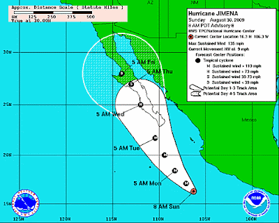
There is a hurricane in the Pacific Ocean, headed directly toward Los Angeles. It’s name is Jimena (pronounced him -ay – nuh, accent on the ay). Jimema currently has winds of 135 miles per hour, and is just south of the tip of Baja, California. Its course is to the northwest, up the Baja peninsula.
Judging from the mass confusion a couple of years ago when Houston evacuated ahead of hurricane Rita, Los Angeles might want to start packing and driving today. Houston only had around 1 million people exiting the city, and had at least five freeways on which to do it. Los Angeles has approximately 3 million people, probably closer to 4 million, but the metropolitan area has 18 million, and only three ways out. There is the Interstate 10, going due East; Interstate 5 going North; and highway 101, also going north. I-5 also goes south, but little good that will do since one runs into San Diego and the hurricane.
A hurricane hitting Los Angeles. We must take prudent steps to avoid the certain disaster and destruction from a hurricane. We will not be required to wait 100 years for the results to be in. This hurricane will be here in less than 10 days. We must act today, while there is still time. The science is settled. Hurricanes hitting major population centers are a serious threat. Remember New Orleans and Hurricane Katrina. Houston and Hurricane Rita. We must mobilize FEMA so they can get their red tape all in order, ready to send trailers and water and food packs to Los Angeles.
The low-lying areas of Southern California are at risk of inundation from the storm surge. Ports and river basins will be swamped with seawater, causing un-told devastation to precious seashore that is a national treasure, as the California Coastal Commission regularly reminds us. A storm surge from a hurricane can be several feet. The California Coastal Commission was in a tizzy recently over the prospect of the ocean rising just one foot, in the next century. Where is the alarm, the hysterical and frantic activity, over a storm surge of 5 to 10 feet in the space of 24 hours?
Where is the clarion call to action from our state and city leaders? Governor Schwarzenegger, Mayor Villaraigosa, are you watching this hurricane? Have you prepared the state and city and county to deal with this?
Or, are you hoping the hurricane does arrive, and right away, so that the wildfires will finally be put out and the firefighters get some much-needed rest?
Stay tuned, sports fans. This is about to get interesting.
Will it be roughly the size of Manhattan? And how would the media exploit this when they can’t use photos of black children or furry animals? When we celebs and gangs suffer we don’t really give a hoot.
And neither should we.
Nice one Roger. And congrats on your first post here. Stay safe if… well you know.
The rain would help with the fires , but then would probably trigger mud/debris flows . I read about the fire/rain/debris flow cycle in one John Mcphee’s books – The Control of Nature , I think .
On December 19, 1973, Johnny Carson made a tongue-in-cheek comment on a toilet paper shortage. Within a few days there was a TP shortage. One has to be careful what one does in these days of mass silliness.
Good post, though. Too bad Jimena is a week away. I’m guessing the rain will be considered beneficial if it puts the fires out and doesn’t cause mud slides. In any case, I would not try 101 as an escape route unless you are first to head north.
Actually, some of dry Arizona’s so-called “400-year floods” happen as a result of Pacific hurricanes that peter out as they mosey up the Baja gulf. I always keep an eye out for such storms at this time of year. We get the leavings of a hurricane every 10 or so years.
Thank you, Ellie. This is great fun.
Here is a link to the hurricane track map, showing just how few ever strike the U.S. west coast. From zooming in, it appears that only one has really hit close to Los Angeles, and that one came in over Long Beach (a suburb of Los Angeles). Another came ashore at San Diego.
http://csc-s-maps-q.csc.noaa.gov/hurricanes/viewer.html
Anthony is quite right, of course, that the cold ocean water and wind conditions make it extremely unlikely that a hurricane will strike Los Angeles. One did, though, and this one might.
Australian researchers now claim to have “proven” that their country’s drought is a result of AGW. (http://www.theage.com.au/national/its-not-drought-its-climate-change-say-scientists-20090829-f3cd.html)
Robust! Tipping point! Precautionary pimple! Everybody who opposes this is in the pocket of Big Oil. Ooooh! When in trouble, when in doubt, run in circles, scream and shout! Vote for Fear, Incorporated.
Being a resident of the Phoenix area, I’m reminded of Hurricane Nora. Predictions called for 4″-6″ of rain for the area (our yearly total is about 7″). The center of the storm headed due north in western Arizona. Here in Phoenix we actually recieved a 3 minute sprinkle. Barely enough to cover the ground. The local paper ran a cartoon showing the media all crowded around a puddle of water proclaiming “The remants of Tropical Storm Nora”.
All joking aside, Arizona has seen some large rainfall events from remnants of dieing tropical storms. However, it has been an exceptionally dry “Monsoon” season. We will gladly accept any rainfall to end our Depressing non-stop sunshine. And to think I moved here to escape the typical dreary cloudy days back east. Most Phoenicians get excited by rain/clouds and depressed by cloudless days.
And yes, droughts come and go. That’s the way it’s always been here in the Southwest. We only have water shortage problems when too many people try to live (and irrigate) off of a given supply during drought times. I just want to puke every time I hear a warmer claim that droughts in the Southwest are becoming more common and things are accelerating at a scary pace, blah blah blah. The only thing that has increased in the Southwest is the minimum temperature readings from measuring stations located near urban areas.
Maybe they’re too busy taking care of the fires and sizzling temperatures?
Here’s a live webcam at Mt Wilson (UCLA astrophysics observatory):
http://www.astro.ucla.edu/~obs/towercam.htm
Ah ye of little faith. The end is nigh, and thou must apply the precautonary principle—NOW!. Abandon the city at all costs, lest ye be called a hurricane denier!
We don’t need no stinkin’ risk/benefit analysis.
Don’t forget Hurricane Ike and the order to evacuate Galveston after the road(s) was/were already under water. That took real careful planning.
The rain would/will be terrible. There will be massive mud flows the first storm that arrives. If you don’t know the area of Big Tujunga Canyon, there are very steep mountains with only a couple of outflow. We’ll be testing the flood control basins for sure.
Will this one leave a track of cold (exausted heat) waters behind?. Have you noticed that Nino 2+3 anomaly is over ( in the northern hemisphere), not below the equator line and nino 1 is cold?
http://www.osdpd.noaa.gov/data/sst/anomaly/2009/anomnight.8.27.2009.gif
BTW Danny´s track still lingers.
Wait for more informed interpretations.
“Precautionary pimple” LMAO
Some “coyotes” are helping this Nino to cross the US southern border line!
Bring it on. We need the rain.
Gee, I don’t know. Hurricane Bill was Cat 3 – and was still Cat 1 near Nova Scotia. The water there is cooler than the water near Los Angeles. Jimena may be a Cat 4 and has warm water most of the way. Unlikely, improbable – yes. But not due to water temp – due to steering air currents.
http://www.weather.com/newscenter/hurricanecentral/2009/bill.html
http://www.wunderground.com/tropical/
Look on the bright side…we need the rain and it would blow all the smoke from the fires over the hill out into the dessert. For us choking from the smoke and our dead lawns, it’s a win-win!
The trajectory above of this huriicane it is the modelled one. I have heard that the real one will be westward (btw. earth circles from west to east).
Nogw (14:58:32) :
I don’t doubt that the path of the hurricane will likely differ from the modeled one but what does “earth circles from west to east” have to do with it? Surely the folks working on these issues learned this at some point in their career!
Also, you must mean you expect the path to be “west of” the modeled path and not “westward” for that seems to say it would curl out into the Pacific Ocean rather than into the continent. Just wondering as I’m unclear which you do mean.
A particularly silly argument, even for this site.
Outstanding thread, Anthony. We should add that it’s all the fault of Santa Barbara Offshore Oil and the Diesel Death Zones (that’s what they call them down there) where the container ships unload.
What is missing is the ocean temps off the coast to support a hurricane skirting Baja to enable Jimena to hydrostatically flow the LA Basin. The consolidation of the rock formations in So. Ca is akin to a pile of cake dough. i.e. – those in the mining industry refer to it as the “Peanut Butter Formation”. The remnants of the storm would then travel north to Big Sur and take out Highway One built on the Soapstone Formation (highly fractured Serpentine).
Run for your lives. Flee, LA, the freeways will go down faster than the Northridge Earthquake
The volume of goo, rock and debris will render the area impassable for months on end.
Then comes the “Big One” 8.0+ Quake, followed by a 400 year Santa Anna wind.
Lord have Mercy, Coastal California won’t sink beneath the waves, it will be melted off by 40″ rains.
John F. Hultquist (15:38:33) :
It would have to head out to the West then curl back in to slam into LA like a brick wall.
The resultant 4 feet of water will run down the hills taking LA out to sea to form a new extended concrete reinforced rubble coastline. Airborne Tsunami.
Wow, this sci-fi stuff is wild.
“alphajuno (13:54:24) :
Gee, I don’t know. Hurricane Bill was Cat 3 – and was still Cat 1 near Nova Scotia. The water there is cooler than the water near Los Angeles. Jimena may be a Cat 4 and has warm water most of the way. Unlikely, improbable – yes. But not due to water temp – due to steering air currents.
http://www.weather.com/newscenter/hurricanecentral/2009/bill.html
http://www.wunderground.com/tropical/”
The circulation of the northeastern Pacific is different from the northwestern Atlantic. The cold water from the north eastern Pacific is moving clockwise down the Alaskan coast towards the equator. There is no similar circulation in the northwestern Atlantic.
Scott (15:44:06) :
A successful parody is often judged “silly” by the targets.
I always enjoy reading Roger Sowell’s columns.
What kind of nation of sheep has to wait for someone in the government to tell them to evacuate? Anyone with any sense evaluates the threat, and makes an individual decision to leave or stay. Anyone who lives on the water, in a weak structure, is dependent a machine that runs on gas or electricity or lives in a house with large overhanging trees or tree limbs can make a rational decision to leave. Everyone else should stay and shelter in place.
Tips & Notes page (on my computer) has lost its submit window. So . . .
Look at the DMI Polar Temperature — it just dropped like a rock in a still pond. WUWT?
I join those hoping for an early rainy season to quench the fires. One man’s hurricane is another man’s life giving rain! To wit, Atlanta GA had a serious drought in 2007 until they finally had a couple of good hurricane in 2008 feeding their watershed. But looks like they’re headed back to drought conditions again, as is Houston since it’s not looking like they’ll get any hurricanes this year.
Which brings me around to Bill Gate funding hurricane calming technology … is he going to take the liability for increasing and extending droughts in the Southeast?
From http://www.seabloger.com
Jimena
hurricanes by seablogger
I don’t usually write about East Pacific hurricanes, but Jimena is unusual. Waters off Mexico are uncommonly warm this summer, and there have been quite a few tropical cyclones, mostly far out to sea. Jimena is moving parallel to the coast, over waters that have not been churned by any other storm. It has accelerated to cat 4, and it may even reach cat 5 tomorrow, as the environment is very favorable. Along its NW fringe, the storm is ventilating extra vigorously because of SW flow from an upper low. This flow may also turn the storm enough to make it hit Baja. By then, shear and slightly cooler water will begin to weaken Jimena, but this has the potential to be an extremely destructive hit for southern Baja; or if the storm recurves a bit earlier, for the Mexican mainland. Other models have the upper low retreating NW, and Jimena following it, to dissipate over the cool sea SW of California. In that case a great deal of high level moisture would be released to energize storminess in the US.
Meanwhile I continue to watch an active tropical wave crossing the Atlantic. It shows signs of imminent development. This system is keeping to a low latitude, and if it becomes a hurricane, it will trouble the Caribbean, not the US, by my reckoniing. Joe Bastardi’s reckoning puts it up the East Coast. If so, there will be a lot of hostile winds to overcome, and a Danny would be more likely than a Bill.
Sometime in the late thirties something near hurricane remnant hit San Francisco. I rember two things; (born 1932) Wind driven rain was bubbling up at the bottom of the window sashes and walking on large blown down trees in Golden Gate Park.
There are quite a few freeways that go east, northwest, and southwest away from the coastal communities, but you are correct, Roger, that the shear scale of evacuation is mind boggling. A scarier prospect is to have nearly 18 million people without services–sanitation, water, food, electricity, fuels, public safety, and so forth. The recent earthquakes (1971, 1995) would be small events in comparison.
This is interesting indeed.
Thanks for the nice read Roger, very entertaining.
I am looking forward to your next publication!
More info here:
http://hurricane.accuweather.com/hurricane/epacific/basin.asp?
and here:
http://www.accuweather.com/news-story.asp?partner=rss&article=7
Leon Palmer (16:13:50) :
Which brings me around to Bill Gate funding hurricane calming technology …
This is a joke, yes? No one is thinking of such lunacy seriously, are they? When I was in graduate school in the mid 1970s people spoke of trying to predict earthquakes and to release strain through “earthquake calming technology.” It is a fantasy to try to “calm nature.” Much better to avoid building in disaster prone regions, engineer structures and facilities to withstand the 99% event, and so forth. There is a lesson in here for response to global warming, too.
John F. Hultquist (16:10:16) :
Uh-oh.
Wonder what other type of birds of a feather will be flocking together?
And it’s going to head up the coast to San Francisco –
Then Portland, Seattle, and Vancouver.
It might even reach Anchorage!
We izz doomed !!!!
Kevin Kilty (16:55:09) About Bill Gates: This is a joke, yes?
Sorry, but no. They have a patent on a series of “pumps” to cover the surface of the seas with cold water – thus, less frequent and damaging storms. Just search for it.
John F. Hultquist (17:40:03) :
Messing with the climate on a global scale, while Bill Gates might manage to do so, is going off the deep end.
I refer to the Mathematician in Jurassic Park who said:
“they forgot to ask the question: Should we be doing this?”.
The answer is what our parents taught us as children:
Look both ways before crossing the street.
Yeah, but… the hurricane would still be less damaging to LA than AB 32, so let’s all not get our undies in a bunch ;o)
(Congrats on your first WUWT post, Roger, and thank you Anthony for putting it on WUWT.)
Roger Sowell, glad to see you posting on WUWT and on a topic so interesting to a fellow metro-Angelino. Be sure to read Roger’s blogs; he’s got lots of great ideas. If a hurricane dropped its load on L.A., the hillsides would melt and the storm drains would be so overwhelmed it is not funny — like Julie’s “400 year flood” in Arizona. I hate to even think of the coastal areas.
We are such babies here in paradise; the weather has been relatively warm in the winter and cool in the summer and our air has not very smoggy. Unbelievable. But every Eden has its snake; these days, as usually happens in August and September, it’s fires. The Station area where our dear friends and relatives had to evacuate has not burned in 60 years — lots of tinder dry brush and scrub trees.
Since we know we can’t get out of the basin in an emergency, e.g., a Mag 7 earthquake, we take CERT training and learn how to help out the fire fighters and police officers. And we stock up with emergency supplies — and a way to protect our supplies. Try E. M. Smith for how to stock up on chiefio.com. He’s a fellow Californian, the golden state where our political “mines” are giving us fool’s gold.
Anthony,
You’re statement, “Since 1900, only four tropical cyclones … ” is of concern to this San Diego homeowner (a mile inland at 200+ feet elevation) who has to fly to Rhode Island tomorrow for five days. Years ago (1980’s), I read an article in the San Diego Union about hurricanes hitting San Diego in the 1880’s. The gist of the article was billions of dollars damage and a re-arranged Coronado Island and other beaches.
I’m also concerned that one of my twin sons, (a Katrina evacuee) who went back to Chico state two weeks ago, reported just before he left, that the water at La Jolla Shores was really warm compared to other years when he went surfing before work.
I never kept the SD Union article, but do you have any sources about Southern California significant storm events in the later half of the 19th century?
In all probability, looking at the five-day predicted path, this storm will collide with Baja and dissipate, but my real interest is in long term trends over several thousand years where we can see the longer cycles in action. To respond properly to AGW, it is necessary to show, in advance if possible, that weather events follow long-term trends. The worst thing that could happen would be LA sliding into the Pacific just before the Senate debates the House passed climate bill.
REPLY: here is a collection. Note there are lots of remnants, just not many with tropical storm force winds.
http://en.wikipedia.org/wiki/List_of_California_hurricanes
“But it’s a fun exercise to discuss the possibility.”
At first read I thought possibility was policy. Anyway, Yes, I’m in favor of hurricanes hitting southern California.
As I recall Kathleen held together pretty well all the way into the Pac Nw. Here in NE Oregon we had what an old ‘Nam hand said was: “The closest thing to a Monsoon as it gets”. I was impressed enough to stay well inside a brick Hangar…
I don’t know what the relationship is of amounts of energy in the two systems, but I have been wondering what might happen if the remnants of the hurricane “mix it up” with the effects of the fires northern rim of the Los Angeles Basin.
The tips page seems to have reached a tipping point, so I’ll post this here as it’s from a San Diego newspaper.
Cap and Trade has reached the political cartoon stage equating it with job loss and another gov’t “Death Panel”
“Proper” link: http://www.creators.com/editorialcartoons/steve-breen/10213.html
Image link: http://www.creators.com/editorial_cartoons/23/10213_image.gif
Richard deSousa
Maybe, but this storm has the big mo’. It’s huge, a monster. Ike damaged many roofs in Ohio last year. Jimena isn’t going to peter out to nothing right away because it’s like a freight train getting slowed down by a headwind – takes a while… I hope it goes out to sea…
Here’s a link to a current CNN item on Gates’s anti-hurricane technology:
http://www.cnn.com/2009/TECH/science/08/28/hurricanes.gates.gray/index.html
SoCal hurricane. That would be bad news.
My house is exactly in the spot where the 1939 hurricane put 6 feet of
water for a few months. Plus I am less than 100′ from the main
drainage, the Santa Ana River.
The LA basin is either unique, or uncommon, in relationship to hurricanes.
When a Pacific storm comes it, it is trapped by the mountains. The
storm cannot move 100 miles without having to go over 10,000 foot
mountain range. As a result, pretty much all the rain and wind energy
has to be dissipated within 100 miles of landfall.
We have been planning _since the 1939_ flood for another hurricane
hit. The 7 Oaks Dam provides a huge holding basin at the headwaters
of the Santa Ana. Recently (100 days ago) the Prado Dam had a huge
upgrade, essentially completing the 30 years of work on the Santa Ana
drainage.
Twill be an interesting problem is it happens.
A big thank you to Anthony for allowing me to guest post here. It’s an honor.
And many thanks to all who wrote such kind words above.
I just returned from visiting some friends who could see the fires in the Big Tujunga area from their back yard. That is just east of the junction of freeways I-5 and 118. The firefighters now say that it will take at least until September 8 to put this one out. Maybe Hurricane Jimena is just what we need – in a weakened state, just the rain and moderate winds. It could be here by then.
Regarding evacuation of a massive urban center with many millions of people, this is a very serious matter and a very tough call for officials. If they give the evacuation order early enough for most of the population to flee, that would be days before the hurricane arrives. Then if the hurricane changes course or dissipates, everyone is unhappy that they evacuated without a good reason. But, if the officials wait until it is certain that the hurricane will hit, it is too late to evacuate that many people. Very tough call.
BTW, how many hurricanes (or any other named stuffs) did the pacific have this year? People always say that El Nino years favour Pacific over Atlantic storms, so does anybody have an idea?
I thought it was the convention that intense tropical cyclones in the Pacific were called Typhoons, whilst those in the Atlantic were Hurricanes. Is this wrong?
We have not had one here in Long Island for a long time. Gloria is the last I remember in the 1980s. Most of them curve out in the Atlantic Ocean before them come up this far north.
Updated trajectory from AccuWeather:
http://www.accuweather.com/news-story.asp?partner=rss&article=7
Los Angeles also has the 15 Freeway to Las Vegas, if anyone is keeping count.
Roger Sowell (21:28:26) :
“Regarding evacuation of a massive urban center with many millions of people, this is a very serious matter and a very tough call for officials. If they give the evacuation order early enough for most of the population to flee, that would be days before the hurricane arrives. Then if the hurricane changes course or dissipates, everyone is unhappy that they evacuated without a good reason. But, if the officials wait until it is certain that the hurricane will hit, it is too late to evacuate that many people. Very tough call”.
Roger,
It’s the most difficult question of our time.
Can we afford a disaster to happen?
I think people should be informed well and decide for themselves.
Even during calls for evacuation due to the fires in California, people decide to stay and protect their homes.
There is no clear solution.
colin artus : (06:26:04) : My wife and I had this discussion a couple of weeks ago . After looking it up , it seems that tropical cyclones in the western Pacific aer called hurricanes , as are those in the Atlantic basin . This might be in the US only , however .
@pyromancer76 There is a great book by my wife’s friend Neil Strauss called “Emergency” that deals with his preparations as an Angeleno for all things that could go wrong, both political and natural disasters. While writing the book, the chain of preparation and education ends up with him becoming CERT trained. Based on your comment, I think you would enjoy it.
@ Eric Chieflion: You’re probably thinking of this system, the San Diego Hurricane of 2 October 1858.
@ colin artus: Intense tropical cyclones in the north Pacific Ocean are called typhoons when they are west of the dateline, and are called hurricanes when east of it.
I believe hurricanes in the Western Pacific are Typhoons & in the Easten Pacific, hurricanes.
I’d be willing to sign a petition to have ALL Pacific hurricanes called typhoons though.
Well, according to the sea surface temperature maps and the odd surfer witness, the waters in the track of this hurricane are warm.
This will be an interesting week indeed.
If this hurricane makes a hit this government will use the event as a stick to hit the Senate.
Minor events like a hurricane can do that.
I call this an example of “bad timing”.
Oops – that should have been EASTERN Pacific – sorry about that .
If Jimena hits Southern California, it will drive me past my tippling point.
Mexico has issued an orange alert in the peninsula of lower California as it is now a category 5 hurricane. It threatens the areas of Culician and Topolobampo
Jimena from space close up:
http://earthobservatory.nasa.gov/NaturalHazards/view.php?id=40002&src=eorss-nh
A protective wall:
http://www.seablogger.com/?p=16677
Jimena won’t put the flames out….!
http://www.accuweather.com/news-story.asp?partner=rss&article=0
Now it is forecast to turn due west, and head back out to sea on Saturday. Los Angeles may yet be in the bullseye.
http://www.accuweather.com/news-story.asp?partner=rss&article=0